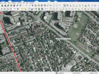
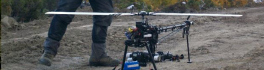
Learn about UAVs at the Ottawa June Social
This is the last month for GoGeomatics Socials before we break for the summer, and in Ottawa we’re going out with a bang, for the ASG Mapping Ottawa GoGeomatics Social! ASG Mapping Ltd is joining […]
GoGeomatics Canada was privileged to play host to Ottawa’s geospatial leaders on Friday night. (If you missed it, you’ll be kicking yourself now!) We expected an interesting turnout, but we did not to expect to […]
On April 19th, the Canadian Remote Sensing Society (CRSS) and GoGeomatics Canada got together with other members of the Ottawa geomatics community to discuss the first draft of the Pan-Canadian Geomatics Strategy. GoGeomatics wants to […]
GoGeomatics Canada would like to thank the following contributors, sponsors and companies/organizations for their support since the relaunch of our new website. Article Contributors Since our website relaunch earlier this year, we have had amazing article […]
The Free and Open Source Software (FOSS) model provides interacting tools, plugs ins and processes with which Geospatial Analyst (GA) can create, barter, trade software and knowledge. FOSS GA are motivated by many factors but […]
During our GoGeomatics Canada website launch party in Ottawa, we encouraged our guests to have a chat about geomatics. Here, we’re speaking with Eduardo Barajas-Garrido, Regie Alam, John Yole and Eric. What do they do, what […]
The City of Ottawa Official Plan set a target of 30% tree canopy cover for the entire city. To the author’s knowledge there is no information on the amount of tree canopy for the entire […]