• facebook
  • Twitter
  • Linkedin
  • Youtube
  • Linkedin Group
  • Post a Job
  • Post an Ad
  • Post an Event
  • Post a Directory Listing
  • Post a Press Release
  • Media Kit
  • My Account
  • Shopping Cart
  • Login
GoGeomatics
  • MAGAZINE
    • BIM & GIS
    • Community
    • Conference news
    • Earth Observation
    • Education & Careers
    • GEOAI
    • Announcements
    • Reality Capture & Lidar
    • Science
    • Technology
    • Between the Poles
  • Directories
    • ASSOCIATION
    • INDUSTRY
    • EDUCATION
    • Open Data
  • EVENTS
    • GeoIgnite Events
    • Events Calendar
    • GoGeomatics Meetups
  • Services
    • Advertising
    • Marketing
    • Post a Job
    • Post an Ad
    • Post an Event
    • Post a Press Release
    • Post a Directory Listing
    • Media Kit
    • Web Design
  • Find a Job
  • Volunteer
    • Start a GoGeomatics Group
    • Editors & Writers Group
  • About Us
    • About Us
    • Contact Us
    • Frequently Asked Questions
  • Videos
Homeremote sensing

remote sensing

|Beluga whales|Beluga Whales2|Beluga whales3
BIM & GIS

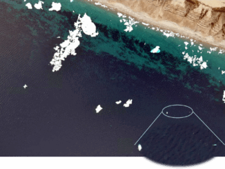
AI Meets Beluga Whales in the Arctic

17 April 2025 Anusuya Datta | AI in Conservation

Flying over Arctic waters, you’d never spot them. Beluga whales vanish against the ice below — their white bodies nearly invisible from above. Fisheries and Oceans Canada (DFO) has always watched these animals closely. For […]

Back to School Social Calgary|JM-geomatics education||what canada needs
Community

Treat Geomatics Like a National Asset, Not an Afterthought

17 April 2025 Jon Murphy | Applied Learning

Across Canada, geomatics and geospatial education are facing a reckoning. Programs are shrinking or disappearing altogether, funding is increasingly scarce, and institutions are being forced to make difficult decisions about what to sustain. Meanwhile, the […]

||GeoIgnite sponsors|Terrasolid logo|GeoIgnite sponsors
Community

Infosat Geomatica and Terrasolid Ltd Join GeoIgnite 2025 as Exhibitors

14 April 2025 GoGeomatics Canada | Canada

Ottawa, Canada – Infosat Geomatica and Terrasolid will participate as exhibitors at GeoIgnite 2025, Canada’s premier geospatial leadership conference, taking place from May 12-14, 2025, at the Ottawa Conference and Event Centre. Infosat Geomatica     Infosat […]

Canadian-digest-April-14|
Earth Observation

Canadian Geospatial Digest – April 14, 2025

14 April 2025 Volunteer Editors and Group Writers | Canada

Wildlife Without Borders: Cross-Border Conservation Under Threat Drones for Disaster: UVic’s Smart Mapping Tool Takes Flight Canada’s Weather Map Flips: Arctic Warmer Than Southern Ontario Restoring the Past: Tremaine Map of Upper Canada Now on […]

Community

Exploring the Future of Hydrospatial Technologies at GeoIgnite 2025

14 April 2025 GoGeomatics Canada | Autonomous Survey Vessels

Hydrospatial technologies are increasingly becoming critical in addressing some of the most pressing environmental and safety challenges. From managing flood risks and monitoring coastal areas to improving maritime navigation and supporting climate resilience, hydrospatial data […]

|PacGeo|Maxar satellite|Maxar satellite|
Earth Observation

Pacific Geomatics Brings Maxar’s WorldView Legion to Canadian Projects

11 April 2025 GoGeomatics Canada | constellation

Pacific Geomatics (PacGeo), a leading Canadian satellite imagery provider, is pleased to announce a limited-time special tasking promotion for Canadian organizations to access high-resolution satellite imagery at an outstanding value. Maxar Intelligence, a longstanding partner […]

CATALYST-joins-geoignite|
Conference news

CATALYST Joins GeoIgnite 2025 as an Exhibitor

7 April 2025 GoGeomatics Canada | AI

Ottawa, Canada – CATALYST will participate as an exhibitor at GeoIgnite 2025, Canada’s premier geospatial leadership conference, taking place from May 12-14, 2025, at the Ottawa Conference and Event Centre. CATALYST, a PCI Geomatics Company, has been […]

|
Earth Observation

Seeing What Lies Beneath: Seafloor Mapping in a Marine Protected Area

7 April 2025 Benedicta Antwi Boasiako | bathymetry

When people think of conservation, they often imagine forests, wildlife reserves, or coral reefs. But what about the deep, quiet stretches of ocean that we know almost nothing about? That’s exactly what makes Ascension Island […]

Posts pagination

« 1 … 15 16 17 … 74 »

Events

Notice
There are no upcoming events.

View All Events

Services

  • Post a Job
  • Post an Ad
  • Post an Event
  • Post a Directory Listing
  • Post a Press Release
  • Media Kit
  • My Account
  • Shopping Cart
  • Login

Jobs

Post a Job
  • GIS Technician
    Sudbury, Ontario
  • Asset/GIS Coordinator
    Edson, AB
  • Civic Operations GIS Technologist (Permanent, Full-Time) – 1953
    Kamloops, British Columbia
  • Senior Manager, Data Science – Geospatial
    Mississauga, Ontario
View All Jobs
  • Directories
    • Associations Directory
    • Industry Directory
    • Education Programs
    • Open Data
  • Volunteer
    • Start a GoGeomatics Group
    • Editors & Writers Group
  • About Us
    • GoGeomatics Media Kit
    • Who We Are
    • Contact Us
    • FAQ’s
    • Advertising
    • Marketing
  • Subscribe
GoGeomatics
GoGeomatics is the largest and most popular communications hub promoting the Canadian geospatial community. The business was incorporated in 2011. GoGeomatics hosts over 100 fun, free, location technology networking events each year in cities across Canada.

© 2026 GoGeomatics

  • facebook
  • Twitter
  • Linkedin
  • Youtube
  • Linkedin Group