
Community
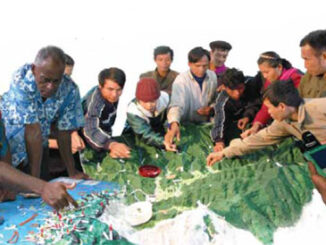
NRCan talks to the United Nations about Geomatics
At the end of last year, I came across what I think is an excellent synopsis of what NRCan and the Canadian Federal Government are focused on in terms of geomatics. All of it is […]
At the end of last year, I came across what I think is an excellent synopsis of what NRCan and the Canadian Federal Government are focused on in terms of geomatics. All of it is […]
Here is the January 1st, 2014 GoGeomatics MERX Report. Login to see the contracts on MERX Geomatics Services Published: 19/12/2013 Closing: […]
By Dr. Brian Ballantyne Surveyor General Branch, NRCan Reprinted from the Ontario Professional Surveyor, Volume 56, No. 4, Fall 2013 Abstract – The south boundary of the Gull River Indian Reserve is a straight line […]
Here is the December 2013 GoGeomatics MERX Report. Login to see the contracts on MERX Cadastral Survey Projects Date Published: 11/18/2013 / Closing: 12/06/2013 Solicitation Number: NRCan-50006013567 Organization Name: Natural Resources Canada By means of […]
Before we close on the final month of 2013, let’s take a moment to look back on this month’s developments in Canadian geomatics news. These are the top Canadian geomatics stories of November 2013. Please […]
Earlier this year, a CBC report brought to light a disturbing trend among Canada’s student population. Fundamental geographic knowledge (as simple as the locations of continents) is not as instilled in many of today’s college-level […]
In recent years, high–resolution spaceborne imagery (HRSI), up to 50cm spatial resolution, has become readily available for no cost using such applications as Google Earth and Bing Maps. Thanks to this new availability of free […]
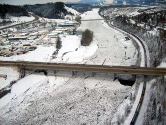
Unprecedented ice jams led to extensive flooding in Prince George as temperatures dipped to record lows in the winter of 2007/2008. City officials declared a state of local emergency on December 11, 2007, ordering dozens […]