QGIS: Performing Viewshed Analysis on Archaeological Sites
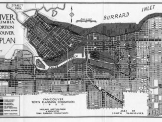
In 1927 a Vancouver bylaw was enacted that limited the height of buildings to a maximum of six stories in height over much of the West End of the city, as illustrated in the Zoning […]
NSCC students make major impact in two small communities with huge historical significance Students at Nova Scotia Community College’s Centre of Geographic Sciences are combining their skills in geomatics with a desire to propel the […]
The Earth Observation (EO) Summit 2017 brings together in one exceptional event the 38th Canadian Symposium on Remote Sensing (CSRS), the 17th Congress of the Association QuĂ©bĂ©coise de TĂ©lĂ©dĂ©tection (AQT), the 11th Advanced SAR (ASAR) […]
One hundred and fifty years after Confederation launched the idea of a railway that would unite the country, the Railway Association of Canada (RAC) today unveiled the Canadian Rail Atlas, which allows visitors to explore that […]
Since December 15, 2016, the new Galileo global satellite navigation system has been up and running. Unfortunately, there are some technical difficulties on the horizon, having to do with the clocks that are on […]
What I want to share with you are some resources related to something called Massive Open Online Course (MOOC) where you can learn new skills, refresh your current ones or to simply satisfy your thirst […]
This is our list Canadian geomatics conferences and events for 2017. Here you will find events pertaining to GIS, remote sensing, surveying, cartography, and informatics. We’re always updating this list, so if you have a […]
Recently, I read an article about the Canadian Geospatial Data Infrastructure (CGDI) that seeks to explain why the CGDI, among many things, is relevant. While the Canada Centre for Mapping and Earth Observation (CCMEO) who is […]