• facebook
  • Twitter
  • Linkedin
  • Youtube
  • Linkedin Group
  • Post a Job
  • Post an Ad
  • Post an Event
  • Post a Directory Listing
  • Post a Press Release
  • Media Kit
  • My Account
  • Shopping Cart
  • Login
GoGeomatics
  • MAGAZINE
    • BIM & GIS
    • Community
    • Conference news
    • Earth Observation
    • Education & Careers
    • GEOAI
    • Announcements
    • Reality Capture & Lidar
    • Science
    • Technology
    • Between the Poles
  • Directories
    • ASSOCIATION
    • INDUSTRY
    • EDUCATION
    • Open Data
  • EVENTS
    • GeoIgnite Events
    • Events Calendar
    • GoGeomatics Meetups
  • Services
    • Advertising
    • Marketing
    • Post a Job
    • Post an Ad
    • Post an Event
    • Post a Press Release
    • Post a Directory Listing
    • Media Kit
    • Web Design
  • Find a Job
  • Volunteer
    • Start a GoGeomatics Group
    • Editors & Writers Group
  • About Us
    • About Us
    • Contact Us
    • Frequently Asked Questions
  • Videos
Homesatellite data

satellite data

Kevin Jones
Conference news

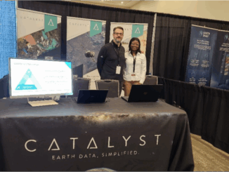
Building What’s Next: Kevin Jones on Innovation and Strategy at Catalyst

9 June 2025 Benedicta Antwi Boasiako | CATALYST

Catalyst, formerly known as PCI Geomatics, is one of Canada’s most recognized geospatial software companies, with a legacy that spans more than four decades in the Earth Observation (EO) space. Known for developing powerful remote […]

Earth Observation

Charting the Future of GeoAI: A Conversation with Nadine Alameh

29 May 2025 Anusuya Datta | AI

What happens when geospatial stops following and starts leading? That’s the question Dr Nadine Alameh posed to the audience during her keynote at GeoIgnite 2025 in Ottawa. She urged the geospatial community to rethink its […]

climate change
Earth Observation

How Geospatial Data Show Us Our Real Environmental Crisis

6 May 2025 Alexander Verbeek | AI

The democratization of geospatial technology means that a farm manager in Costa Rica can check the exact moisture levels of every hectare through a simple phone app like CropX or Climate FieldView, predict pest infestations […]

Canadian-digest-Apr-29
BIM & GIS

Canadian Geospatial Digest – April 29, 2025

29 April 2025 Volunteer Editors and Group Writers | alberta

AI and thermal drones are helping find the lost in B.C.’s mountains Split city: Some B.C. voters don’t feel represented as urban centres carved into sprawling, rural ridings Canadian satellite launches could set record in […]

Maxar bronze sponsor|GeoIgnite sponsors
Conference news

Maxar Joins GeoIgnite 2025 as Bronze Sponsor

25 April 2025 GoGeomatics Canada | AI

Ottawa, Canada: Maxar, a global leader in Earth Intelligence and space-based solutions, has officially joined GeoIgnite 2025 as a Bronze Sponsor and Exhibitor. GeoIgnite 2025, taking place from May 12-14, 2025, at the Ottawa Conference […]

NASA fleet
Earth Observation

From Landsat to Letdown: Fifty Years of Space-Based Earth Observation Now at Risk

18 April 2025 Anusuya Datta | Climate Change

As the U.S. proposes deep cuts to NASA and NOAA, climate scientists warn of lasting damage to the global systems we rely on to track a changing planet. In 1972, the U.S. launched Landsat, the […]

Community

Exploring the Future of Hydrospatial Technologies at GeoIgnite 2025

14 April 2025 GoGeomatics Canada | Autonomous Survey Vessels

Hydrospatial technologies are increasingly becoming critical in addressing some of the most pressing environmental and safety challenges. From managing flood risks and monitoring coastal areas to improving maritime navigation and supporting climate resilience, hydrospatial data […]

Arctic
Earth Observation

Canada Explores OTHR Horizons, New Partnerships to Maintain Arctic Sovereignty

31 March 2025 Anusuya Datta | Arctic Defense

Canada’s Arctic strategy just got a serious tech upgrade. A new $6-billion collaboration with Australia will develop an Over-the-Horizon Radar (OTHR) system. This cutting-edge technology is set to monitor Canada’s northern air and maritime approaches, […]

Posts pagination

« 1 2 3 4 5 »

Events

Notice
There are no upcoming events.

View All Events

Services

  • Post a Job
  • Post an Ad
  • Post an Event
  • Post a Directory Listing
  • Post a Press Release
  • Media Kit
  • My Account
  • Shopping Cart
  • Login

Jobs

Post a Job
  • GIS Technician
    Sudbury, Ontario
  • Asset/GIS Coordinator
    Edson, AB
  • Civic Operations GIS Technologist (Permanent, Full-Time) – 1953
    Kamloops, British Columbia
  • Senior Manager, Data Science – Geospatial
    Mississauga, Ontario
View All Jobs
  • Directories
    • Associations Directory
    • Industry Directory
    • Education Programs
    • Open Data
  • Volunteer
    • Start a GoGeomatics Group
    • Editors & Writers Group
  • About Us
    • GoGeomatics Media Kit
    • Who We Are
    • Contact Us
    • FAQ’s
    • Advertising
    • Marketing
  • Subscribe
GoGeomatics
GoGeomatics is the largest and most popular communications hub promoting the Canadian geospatial community. The business was incorporated in 2011. GoGeomatics hosts over 100 fun, free, location technology networking events each year in cities across Canada.

© 2026 GoGeomatics

  • facebook
  • Twitter
  • Linkedin
  • Youtube
  • Linkedin Group