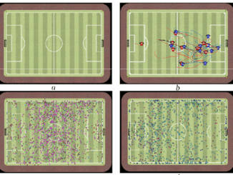
Google Earth Engine – What is a Data Cube and Why Canadians Should Care
What is a data cube and how is it used for big data analytics? How does a data cube work with remotely sensed data? Before writing this article I had never heard of a data […]
At the end of last month, John Wian hosted the Annual General Meeting (AGM) of the CANMAP Research Institute in Bridgetown. The CANMAP Research Institute was formed in the early 1980’s by John, with input […]
The UBC Faculty of Forestry is excited to announce that the official approval of the Master of Geomatics for Environmental Management (MGEM) Program. We are now accepting applications and will welcome our first cohort in August, […]
You might be an observant professional in a department that uses GIS. Your organization may be large and have many departments for which location is important. If that is the case, there is a strong […]
I have studied Geographic Information Systems (GIS) in both Canada and China. Last summer I completed my master in geography at University of Waterloo. In this article I will draw upon my experiences in China and […]
Image source: www.tiobe.com Every now and again we hear about the importance of programming for Geographic Information Systems(GIS) professionals, that is quickly becoming a key in the evolution of one’s career. It is argued that […]
The Canadian Institute of Geomatics (CIG) is pleased to announce its new President, Rodolphe Devillers, PhD, Professor in Geography at Memorial University of Newfoundland, Canada, where he leads the Marine Geomatics Research Lab, a team […]
Interested in how to conduct different types of spatial exposure assessments for air pollution or other exposures to a population? PHDA04: Spatial Epidemiology and Outbreak Detection is a great place to start. Exposure assessment is the […]