• facebook
  • Twitter
  • Linkedin
  • Youtube
  • Linkedin Group
  • Post a Job
  • Post an Ad
  • Post an Event
  • Post a Directory Listing
  • Post a Press Release
  • Media Kit
  • My Account
  • Login
GoGeomatics
  • MAGAZINE
    • BIM & GIS
    • Community
    • Conference news
    • Earth Observation
    • Education & Careers
    • GEOAI
    • Announcements
    • Reality Capture & Lidar
    • Science
    • Technology
  • Directories
    • ASSOCIATION
    • INDUSTRY
    • EDUCATION
    • Open Data
  • EVENTS
    • GeoIgnite Events
    • Events Calendar
    • GoGeomatics Meetups
  • Services
    • Advertising
    • Marketing
    • Post a Job
    • Post an Ad
    • Post an Event
    • Post a Press Release
    • Post a Directory Listing
    • Media Kit
    • Web Design
  • Find a Job
  • Volunteer
    • Start a GoGeomatics Group
    • Editors & Writers Group
  • About Us
    • About Us
    • Contact Us
    • Frequently Asked Questions
  • Videos
HomeSUMSF

SUMSF

||||||
Technology

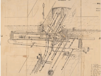
NYC’s Underground Infrastructure Interoperability is discussed at SUMSF

22 June 2022 GoGeomatics Canada | Alan Leidner

The UNUM project shows the benefits of infrastructure collaborations. At a March 23, 2022, SUMSF live stream presentation, participants were able to hear about the UNUM project and NYC’s approach to underground infrastructure interoperability. The […]

|||
Technology

DGT Combines Traditional and Advanced Technologies to advance Unground Mapping

21 June 2022 GoGeomatics Canada | BIM

Best practices come from using radar tomography to augment underground utility locating. SUMSF live stream on March 23, 2022, treated participants to a presentation by Michael Twohig, Subsurface Utility Mapping with DGT Associates, and Mitchell […]

|||
Technology

Two New Standards for Utility Infrastructure Data Introduced At SUMSF

20 June 2022 GoGeomatics Canada | 3D

With one million strikes in the USA, it works out to one strike a minute during a 10 hour work day. During a March 22, 2022, livestream presentation, Philip Meis, President of Utility Mapping Services, spoke […]

||
Technology

InfraMappa Introduces Software to Assist Construction Planning and Execution

19 June 2022 GoGeomatics Canada | Better GIS

Construction companies are saving time and money by using a new software that enables them to view virtual sites. On March 23, 2022, a live stream presentation by Moufid Charafeddine, CEO of InfraMappa, was held […]

||
Technology

PriSUM Technologies Discusses the NJ DOT Project and How IMU Mapping Tools Reduce Damages

17 June 2022 GoGeomatics Canada | 3D Gyro mapping system

PriSUM Technologies believes in a proactive approach. The last livestream presentation of SUMSF on March 23, 2022, was given by Santosh Saride, the VP of Strategy & Business Development for PRISUM Technologies, a division of […]

||||||
Technology

SUMSF Panel Discusses a Canadian Subsurface Digital Twin and the Canadian Underground Infrastructure Register Project

13 June 2022 GoGeomatics Canada | 4Sight Utility Engineers

An informative discussion recently took place in hopes to reduce the billion-dollar infrastructure damage occurring in Canada every year during excavations. During the March 22, 2022 SUMSF live stream panel presentation on developing a subsurface […]

||
Community

Canada’s Geospatial Sector Adapts to Online and In-Person Events

30 May 2022 Jacob Pesaruk | @LiDARCOMEX

Event Overview and Shift to the Online Medium  Over the last few years, events within the geospatial community have undergone drastic changes. Events that were once in-person have gone online and now continue to pivot […]

|
Technology

Developing a subsurface digital twin for Canada: A call to action

2 May 2022 Geoff Zeiss | CAD

Damage to underground infrastructure during construction costs the Canadian economy about $3 billion in direct and indirect costs every year. It is among the biggest causes of delays and budget overruns on public construction projects. […]

Posts pagination

« 1 … 3 4 5 »

Events

Notice
There are no upcoming events.

View All Events

Services

  • Post a Job
  • Post an Ad
  • Post an Event
  • Post a Directory Listing
  • Post a Press Release
  • Media Kit
  • My Account
  • Login

Jobs

Post a Job
  • Canada Maps and Poster Gallery Volunteer Leads — GeoIgnite 2026
    remote
  • GIS & Data Analytics Lead
    Beaumont, AB
  • Lead Surveyor, Projects/Arpenteur-géomètre principal, projets; arpenteuse-géomètre principale, projets
    North Bay, Thunder Bay
  • Senior GIS Developer
    Calgary, AB
View All Jobs
  • Directories
    • Associations Directory
    • Industry Directory
    • Education Programs
    • Open Data
  • Volunteer
    • Start a GoGeomatics Group
    • Editors & Writers Group
  • About Us
    • GoGeomatics Media Kit
    • Who We Are
    • Contact Us
    • FAQ’s
    • Advertising
    • Marketing
  • Subscribe
GoGeomatics
GoGeomatics is the largest and most popular communications hub promoting the Canadian geospatial community. The business was incorporated in 2011. GoGeomatics hosts over 100 fun, free, location technology networking events each year in cities across Canada.

© 2025 GoGeomatics

  • facebook
  • Twitter
  • Linkedin
  • Youtube
  • Linkedin Group