DGT Combines Traditional and Advanced Technologies to advance Unground Mapping
Best practices come from using radar tomography to augment underground utility locating.

DGT Associates, Surveying and Engineering
SUMSF live stream on March 23, 2022, treated participants to a presentation by Michael Twohig, Subsurface Utility Mapping with DGT Associates, and Mitchell Liddell, Geophysicist and GPR Lead at DGT Associates. They discussed the best practices for underground mapping by combining traditional methods with advanced utility locating and mapping technology.

Michael Twohig, Subsurface Utility Mapping with DGT Associates,
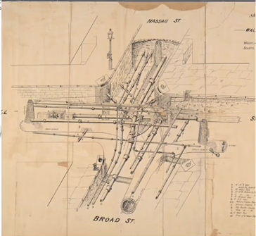
Participants enjoyed a brief, but informative, historical overview of SUM (subsurface utility mapping) in the area. The Boston area had a long history of mapping above and below the ground. To DGT, it’s not just about mapping utilities, it is also about mapping critical infrastructure.
Today’s challenge is that asset owners have stopped updating records, while more utilities keep being added. Finding information can be challenging. Modern GIS doesn’t always solve the problem either. Combining traditional and advanced technologies help mitigate errors and omissions.
With SUM projects, the colour-coded, annotated lines represent all utilities. Subsurface utility plans, with the use of older documents, can verify current plans and validate systems. SIM (subsurface information modeling) was also discussed.
Reasons to have mobile mapping platforms were presented. These platforms take away the need to walk into busy lanes of traffic, and other unnecessary risks.

Mitchell Liddell, Geophysicist and GPR Lead at DGT Associates
The costs of underground mapping errors and omissions were discussed, with examples provided of freeway building and construction delays, as well as soaring costs.
Mapping with ground-penetrating radar (GPR) and incorporating subsurface utility maps was introduced to participants. GPR data collection, resolution, and applications were shown, as well as the benefits when used to determine depths, safe utility tracing, fast collection, confirm locations, and finding unknown features.
The presentation included creating subsurface and mapping awareness today since knowledge of past projects helps with mapping underground infrastructure and damage protection.
You can watch this informative SUMSF presentation on YouTube below.


