• facebook
  • Twitter
  • Linkedin
  • Youtube
  • Linkedin Group
  • Post a Job
  • Post an Ad
  • Post an Event
  • Post a Directory Listing
  • Post a Press Release
  • Media Kit
  • My Account
  • Login
GoGeomatics
  • MAGAZINE
    • BIM & GIS
    • Community
    • Conference news
    • Earth Observation
    • Education & Careers
    • GEOAI
    • Announcements
    • Reality Capture & Lidar
    • Science
    • Technology
  • Directories
    • ASSOCIATION
    • INDUSTRY
    • EDUCATION
    • Open Data
  • EVENTS
    • GeoIgnite Events
    • Events Calendar
    • GoGeomatics Meetups
  • Services
    • Advertising
    • Marketing
    • Post a Job
    • Post an Ad
    • Post an Event
    • Post a Press Release
    • Post a Directory Listing
    • Media Kit
    • Web Design
  • Find a Job
  • Volunteer
    • Start a GoGeomatics Group
    • Editors & Writers Group
  • About Us
    • About Us
    • Contact Us
    • Frequently Asked Questions
  • Videos
Hometechnical

technical

No Picture
Community

Web Framework for Flood Risk Assessment: Elevation Services and Simplified Flood Models

5 December 2015 Heather McGrath | accuracy

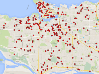
The development of infrastructure and dense urbanization along water courses and the increasing severity of storm events has brought to focus the need for methods for evaluating the potential negative impact to communities. While many […]

||
Community

Local Action & Geomatics: the Gowgaia Institute on Haida Gwaii

27 November 2015 Robert Maher | 2015

This blog is a sequel to last month’s discussion on ‘think global, act local‘. It looks at the the Gowgaia Institute and their use of Geomatics technologies, including an interview with John Broadhead a director […]

No Picture
Newsmakers & Press Releases

Phase One Industrial Releases Software Development Kit 8.3.3 for Developers of Aerial Systems

26 November 2015 GoGeomatics Newsmakers | Acquisition

Phase One Industrial announced the Phase One Software Development Kit (SDK) 8.3.3 in Linux, Windows and Mac OS versions. This SDK provides tools that enable users to build custom applications to control the way Phase […]

GIS and Geomatics Mentors
Education & Careers

On the Importance of Mentoring in Geomatics

24 November 2015 Gene | 3D

I guess I was lucky. It seems to me that I always wanted to be a civil engineer, but if asked I think we all have someone that we can identify as a mentor. The […]

||
Education & Careers

Getting to First Base with GIS

10 November 2015 GIS Program Langara CS | analysis

A friend of mine who volunteers with a girls’ softball team came to me with a request recently. “I have the addresses of all of the girls in our softball league”, she said. “I want […]

No Picture
Education & Careers

Dr Robert Maher on Geoliteracy: ‘Think global, act local’

22 October 2015 Robert Maher | 2015

This month (October) Digital Earth 2015 (DE2015) was held in Halifax. There were a number of keynote presentations, including those by Michael Goodchild (Keeping the Dream Alive ) and Lynn Moorman and James Boxall. (Digital […]

No Picture
Technology

Web Mercator: the de facto standard, the controversy, and the opportunity

23 September 2015 Emmanuel Stefanakis | 2014

Four hundred and fifty years ago, the Flemish geographer and cartographer Gerardus Mercator presented the most popular map projection ever. It became fairly the standard projection for nautical maps because of its ability to represent […]

No Picture
Newsmakers & Press Releases

GPS Galileo taking flight: ten satellites now in orbit

16 September 2015 GoGeomatics Newsmakers | api

Europe’s own satellite navigation system has come a step nearer to completion, with Galileo 9 and 10 which lifted off together at 02:08 GMT on 11 September (04:08 CEST; 23:08 local time, 10 September) from Europe’s […]

Posts pagination

« 1 … 6 7 8 … 22 »

Events

Notice
There are no upcoming events.

View All Events

Services

  • Post a Job
  • Post an Ad
  • Post an Event
  • Post a Directory Listing
  • Post a Press Release
  • Media Kit
  • My Account
  • Login

Jobs

Post a Job
  • Canada Maps and Poster Gallery Volunteer Leads — GeoIgnite 2026
    remote
  • GIS & Data Analytics Lead
    Beaumont, AB
  • Lead Surveyor, Projects/Arpenteur-géomètre principal, projets; arpenteuse-géomètre principale, projets
    North Bay, Thunder Bay
  • Senior GIS Developer
    Calgary, AB
View All Jobs
  • Directories
    • Associations Directory
    • Industry Directory
    • Education Programs
    • Open Data
  • Volunteer
    • Start a GoGeomatics Group
    • Editors & Writers Group
  • About Us
    • GoGeomatics Media Kit
    • Who We Are
    • Contact Us
    • FAQ’s
    • Advertising
    • Marketing
  • Subscribe
GoGeomatics
GoGeomatics is the largest and most popular communications hub promoting the Canadian geospatial community. The business was incorporated in 2011. GoGeomatics hosts over 100 fun, free, location technology networking events each year in cities across Canada.

© 2025 GoGeomatics

  • facebook
  • Twitter
  • Linkedin
  • Youtube
  • Linkedin Group