
Community
Open Data, Open Source, Open Possibilities
Back in 2006 I (Jim) was a student at BCIT and a Vancouver resident, eager to obtain some local data for a project. I sent a hopeful email to City of Vancouver (COV) requesting the […]
Back in 2006 I (Jim) was a student at BCIT and a Vancouver resident, eager to obtain some local data for a project. I sent a hopeful email to City of Vancouver (COV) requesting the […]
Phase One Industrial announced the Phase One Software Development Kit (SDK) 8.3.3 in Linux, Windows and Mac OS versions. This SDK provides tools that enable users to build custom applications to control the way Phase […]
VANCOUVER, Esri Canada User Conference – November 17, 2015 – The District of Squamish is a fast-growing municipality between the City of Vancouver and the Resort Municipality of Whistler in British Columbia. As people strive […]
Cambridge, ON – November 23, 2015 – exactEarth Ltd., the leading provider of Satellite AIS data services, announced today that it is investing AUD $2M to secure a minority ownership position in technology company, Myriota […]
REGINA, Esri Canada User Conference – November 3, 2015 – Esri Canada today presented John Potter, a professional engineer who has retired from the government of Saskatchewan, with the Roger F. Tomlinson Lifetime Achievement Award […]
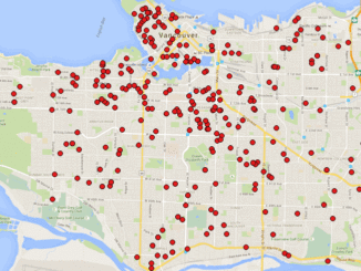
A friend of mine who volunteers with a girls’ softball team came to me with a request recently. “I have the addresses of all of the girls in our softball league”, she said. “I want […]
Elevation Web Services: Limitations and Prospects Elevation data is necessary for a wide range of geospatial applications such as creating relief maps and rendering 3D visualizations, deriving the slope and aspect of a geographic area, […]
DigitalGlobe, Inc. (NYSE: DGI), a leading global provider of commercial high-resolution earth observation and advanced geospatial solutions, today announced an expanded partnership agreement with Mapbox that will make 30 cm imagery basemaps of hundreds of […]