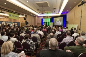
 For the third year in a row the TECTERRA Geomatics Showcase is back – and this year, it’s bigger and better than ever! Incorporating tradeshow style exhibitor booths and top-notch plenary sessions, the TECTERRA Geomatics Showcase 2013 provides numerous networking opportunities, keynote speakers and a chance to learn about the latest breakthrough technology in the geomatics field!
The free event, which takes place on Tuesday, June 18, 2013 at the Westin Hotel in Calgary, Alberta, features over 40 of Canada’s top geomatics companies showcasing their technology. It also hosts a plenary session that features a number of special guests, including:
- The Honourable Gary Goodyear, Minister of State for Science & Technology
- The Honourable Thomas A. Lukaszuk, Alberta Deputy Premier & Minister of Enterprise and Advanced Education
- Ryan Holmes, CEO of HootSuite, one of Canada’s most successful tech startups
We invite you to join us at the TECTERRA Geomatics Showcase 2013, which is the premier forum for the geomatics and business community from across Canada to gather and exchange ideas and share innovative practices!
If you want to stay up-to-date on the newest innovations and the upcoming trends in geomatics technology, you will not want to miss this event! The TECTERRA Geomatics Showcase 2013 is a free event, but you must be registered to attend. Register today!
Event Details:
The TECTERRA Geomatics Showcase 2013
The Westin Calgary – 320, 4th Avenue SW, Calgary, AB
Showcase: 9:30 am – 5:00 pm
Plenary session: 1:00 pm – 3:00 pm
For more information, please visit the TECTERRA website at http://www.tecterra.com/showcase.html


Be the first to comment