
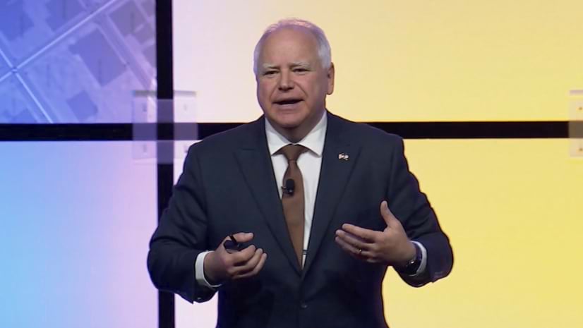
When Tim Walz took the stage at the 2024 ESRI User Conference in San Diego, it was evident that his deep-seated passion for GIS was more than just a professional interest — it was a central part of his identity. As the Governor of Minnesota, Walz had already made significant waves in the GIS community, but few could have anticipated that this self-proclaimed “GIS nerd” would soon be thrust into the national spotlight as Democratic Presidential candidate Kamala Harris’s running mate in the 2024 presidential election.
The GIS Advocate at ESRI
Walz’s keynote at the ESRI conference was more than a showcase of GIS technology; it was a powerful argument for the role of spatial data in effective governance. Standing before an audience of geospatial professionals and map enthusiasts, Walz passionately articulated how GIS is integral to his approach to public policy: “You can’t hope we bring equity into how we are doing power and economic justice and environmental justice. You have to have a plan. The tools for the plan are GIS.”
The end product of these maps is a more sustainable economy, a more sustainable environment, and lifting up people’s lives in a way that they can thrive,” he asserted.
For many in the audience, Walz’s presentation was not just a technical lecture but a compelling narrative about the impact of GIS on real-world issues.
“He’s one of us, Jack [Dangermond],” we heard one of the presenters exclaiming.
Interestingly, Walz shared some personal anecdotes during his Esri address that offered insight into his early fascination with geography. Growing up in a small town in Nebraska, he spent summers working on a cattle ranch.
“Where you are, as Jack said, has a lot to do with who you are,” he reminisced.
So, with nothing much to do in the evenings at the bunkhouse in a remote ranch, he spent his time poring over old issues of National Geographic, dreaming of exotic places far away. This is what sparked his early interest in geography.
Later, during his time in the army, he earned a degree in geography, which eventually led him to become a teacher. It was at a geography conference in the early 1990s that he picked up a floppy disk with a free copy of Esri’s GIS software, which he taught himself.
“I said to my colleagues, ‘This is going to change the way we teach and change the world… 25 years after Jack [Dangermond] figured that out!’”
His love for maps, which began in those formative years, has since influenced how Minnesota has tackled issues like childhood poverty, communicated about the COVID-19 pandemic, and addressed climate change.
From Classroom to Capitol Hill
Tim Walz’s journey into GIS began long before his political career. As a geography teacher in Mankato, Minnesota, Walz was an early adopter of GIS technology. His innovative teaching methods included using GIS to explore complex global issues with his students. One memorable project involved mapping factors related to genocides, allowing students to analyze data on food insecurity and potential droughts to predict conflicts.
One of Walz’s noteworthy classroom achievements, highlighted in a 2008 New York Times article, was his students’ use of advanced mapping data in 1993 to accurately predict the Rwandan genocide, which tragically resulted in the deaths of around 800,000 people just a year later.

This early experience with GIS not only engaged his students but also demonstrated Walz’s belief in the power of spatial analysis to address critical issues. His commitment to using GIS as an educational tool laid the groundwork for his later political work, where he would apply these principles to public policy.
Transforming Governance with GIS
When Walz transitioned to politics, first as a member of the U.S. House of Representatives and later as Governor of Minnesota, he carried his GIS expertise with him. In Congress, he became known for his sharp critiques of colleagues who lacked geographical knowledge. His frustration with what he perceived as geographical ignorance among lawmakers often spilled over into his public remarks. He criticized the lack of understanding of global geography, exemplified by his comments about the Durand Line, a disputed border between Afghanistan and Pakistan.
As Governor of Minnesota, Walz’s use of GIS became a cornerstone of his administration. His commitment to spatial data was evident in several high-profile initiatives aimed at improving governance and public services. During the COVID-19 pandemic, the Minnesota administration relied heavily on GIS to track and visualize the spread of the virus. This data-driven approach was crucial for managing medical resources, implementing public health measures, and transparently communicating infection rates to the public.

One of Walz’s notable achievements is the creation of the Minnesota Geospatial Commons, an online platform designed to provide access to geographic data for state agencies, local governments, and the public. This initiative reflects Walz’s belief in the power of GIS to foster collaboration and support informed decision-making. By making spatial data more accessible, the Geospatial Commons aims to enhance transparency and facilitate data-driven governance.
Another significant project under Walz’s leadership is the interactive map developed for the town of St. Paul to help homeowners identify and replace lead pipes. This map allows residents to check their addresses and schedule pipe replacements, demonstrating how GIS can have a direct, positive impact on community health.
“GIS helps build trust,” Walz has stated, highlighting how visualizing data can make government actions more transparent and trustworthy.
Walz’s use of GIS also extends to policy areas beyond public health. His administration has employed spatial data to address issues such as environmental sustainability, economic development, and social equity. For example, the Minnesota Executive Map Portfolio, a collection of online maps showcasing data on children and families, climate, and the economy, reflects Walz’s commitment to using GIS to translate broad policy goals into specific, actionable insights.
In 2022, Minnesota’s Climate Action Framework set targets to reduce carbon emissions 50% by 2030 and achieve net-zero emissions by 2050. Walz’s administration has also pioneered efforts such as adopting California’s clean car standards and expediting permits for new energy projects.
Challenges and Criticisms
Despite his enthusiasm for GIS, Walz has faced criticism for some of his remarks related to maps and spatial data. One notable controversy arose from his criticism of red-blue electoral maps, which he argued oversimplified political landscapes and contributed to national divisions. His comments about the “rocks and cows” in rural areas, which became a contentious topic among his opponents, reflect the challenges of navigating political discourse with a GIS enthusiast’s perspective.
However, these controversies have not diminished his commitment to using GIS for social good. His passionate defense of the role of maps in driving social change and enhancing transparency remains a central part of his political identity.
At the 2024 Esri conference, Walz’s enthusiasm for GIS was palpable. “This stuff works. This stuff makes a difference. The map is wonderful to look at. It’s exciting!”
Making Waves on the National Stage
Walz’s rise to national prominence as Kamala Harris’s running mate brings brought his GIS expertise into the spotlight. His background as a GIS enthusiast and his innovative approach to using spatial data in governance offer a unique perspective on how technology can be harnessed for public good.
As Walz campaigns for the vice-presidency, his experience with GIS is likely to influence national discussions about technology’s role in public policy, especially regarding the environment and climate change.
His work in Minnesota exemplifies how geospatial data and technologies can be harnessed to tackle pressing issues like climate change and resource management, reinforcing the notion that good governance is deeply intertwined with innovative technological solutions. As he continues his campaign, Walz’s expertise in GIS and environmental policy will undoubtedly influence the conversation on how we can build a more sustainable and informed future.
“We have got to get the literacy on geography and GIS out to the broader public,” he declared emphatically at the ESRI UC.
It’s a call to action, and one we should all rally behind.


Be the first to comment