
This interview is part of our series on Canada’s infrastructure moment and its impact on the geospatial/geomatics sector.
Canada is entering a period of unprecedented infrastructure investment, and with it comes a defining question: Is the geomatics sector ready to deliver? From workforce shortages and shifting procurement models to the rise of new digital tools, the challenges are as significant as the opportunities.
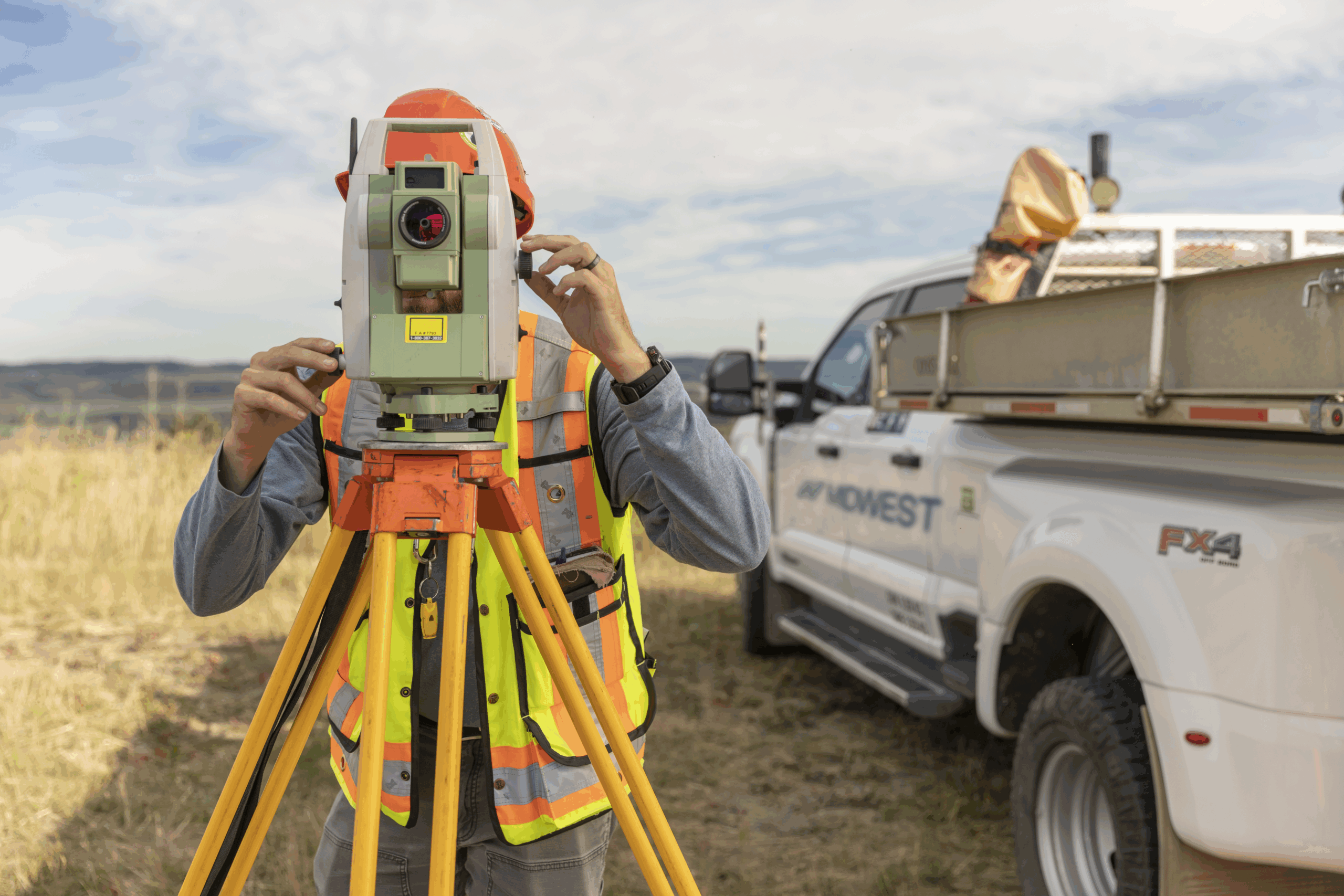
At GoGeomatics, we’re running a series of conversations with industry leaders to take stock of how the sector is preparing to meet this moment. In this installment, we speak with Alex Penner, Chief Operations Officer of Midwest Surveys.
Headquartered in Calgary, Midwest Surveys is one of Western Canada’s most established geomatics firms, providing surveying, mapping, and land management expertise to clients across energy, infrastructure, and construction. With decades of experience supporting major projects, Midwest offers a valuable perspective on how the industry is adapting to new demands and uncertainties.
In our conversation, Penner reflects on the preparedness of the geomatics profession to meet this nation-building moment, the growing importance of geospatial intelligence in construction, the potential of technologies like digital twins and Lidar, and the pressing need to attract and train the next generation of surveyors and spatial professionals. His insights highlight both the strengths the industry brings to the table and the gaps it must close if Canada is to succeed in its infrastructure buildout.
Excerpts:
Canada is embarking on its largest infrastructure investment in decades, with major commitments to civil preparedness, industrial capacity, and core infrastructure. Do you see this as a nation-building moment for the geomatics and infrastructure sectors?
The geomatics sector, especially in Western Canada, has been well-prepared for the anticipated increase in infrastructure development. Many firms, including Midwest Surveys, have used periods of lower activity to critically assess their client solutions and ensure that all geomatics products provide added value beyond traditional paper plans.
With many firms taking a similar approach, I’d say yes, this is undoubtedly a nation-building moment for Canada. We’re ready to rise to the challenge.
How is Midwest preparing for the opportunities tied to this federal commitment?
Midwest recognizes that while federal commitments generate momentum, they are only one part of a complex process in moving infrastructure projects forward. At this stage, we are seeing some early increases in conversations, but many additional factors — such as provincial alignment, regulatory approvals, and client priorities — will ultimately determine how quickly opportunities materialize.
Our preparation is rooted in a long-term growth strategy that acknowledges the inherent volatility of our industry. This means we continue to invest consistently in training and engaging our staff, while also researching and adopting new technologies to improve efficiency and service delivery. By focusing on readiness rather than reacting to single announcements, we ensure that Midwest is well-positioned to respond as opportunities emerge.
How central is geospatial intelligence to the projects under this national agenda?
The correlation between spatial data and successful project execution across all sectors has been growing consistently year over year. As new technologies and practices emerge (and existing ones are refined) collaboration becomes even more critical to project success. A common theme among firms is the sentiment: “I didn’t know you could do that.”
Geomatics technologies are becoming increasingly integrated into our daily tasks and activities, both personally and professionally. Many people interact with geomatics solutions daily without even realizing it. The conversation between sectors should now focus on: “How far can we reliably push this technology?” and “What else can we apply it to?”
Geomatics professionals are well-equipped, in both imagination and implementation to help other sectors identify and capitalize on the advantages of these technologies.
Is collaboration between geomatics, engineering, and construction firms where it needs to be?
I would say the necessary structure is already in place to allow the various stakeholders to work well together. Geomatics and engineering support different aspects of construction and have a long history of working together to facilitate projects in Canada.
An increase in funding for construction should serve to create a larger job market for both engineering and geomatics companies, as the services they provide move into higher demand.
With shifting geopolitical conditions, how do you think about supply chains, data control, or dependencies on external platforms?
That’s a tough one for us to answer directly. Our involvement with supply chains is usually at the client level, so in relation to federal infrastructure projects, we’re often engaged as a subcontractor with a geomatics specialty. As the role of geomatics professionals in these projects increases, the scope of a geomatics firm increases. What this means is that supply chain documents or RFP instructions often omit critical aspects of geomatics support to a successful project.
Collaborating with our industry partners helps increase visibility of the geomatics services that a firm such as Midwest can offer to help increase efficiencies along the project lifecycle. This becomes challenging when the increased cost of these geomatics services draws the attention of the supply chain. An increase in geomatics services cost often provides larger cost savings within the entire project.
This raises a question about the extent to which post-project review supply chain teams actually contribute. I don’t know if that’s happening. What I do know is that we can’t just throw up our hands. It’s on us to keep collaborating and educating clients and partners about the value of geomatics.
Professional Land Surveying — and the broader geomatics community — hasn’t historically had the benefit of high public visibility, even though the public interacts with some sort of technology, process, or regulation developed or supported by geomatics professionals daily (i.e., navigation in vehicles, enjoying your home or property without anyone infringing on your rights to enjoy that property). The geomatics industry bears the onus on ensuring this profession gets more public visibility.
What role do you anticipate technologies like digital twins, Lidar, remote sensing, and AI-based modeling will play in the delivery of Canada’s transformative infrastructure plan?
Technologies like digital twins supported by tools such as Lidar and remote sensing offer significant advantages, particularly in engaging stakeholders who may be geographically distant from a project. The ability to create accurate models and digital environments that reflect real-world conditions is remarkable, especially when combined with technologies like virtual reality (VR).
Interactive environments enhance the way we consume and process information, allowing stakeholders to quickly grasp the global scope of a project. While on-the-ground presence remains essential for successful infrastructure development, these technologies offer new perspectives and improved visibility for all involved.
Think about how often people casually explore Google Earth; applying similar data visualization techniques to infrastructure projects only strengthens our ability to execute them effectively.
Workforce availability remains a major constraint in the geomatics and construction sectors. Are you experiencing challenges in this area?
Attracting talent remains a consistent challenge. While these challenges are varied and cyclical, there is a clear onus on the geomatics sector to improve visibility into the breadth and scope of careers available. Clear communication about what a career in geomatics entails is essential for engaging both current and prospective professionals.
In which roles or skillsets are the shortages most apparent — surveyors, GIS techs, field crews, project managers?
All of the above. We’re also seeing that several schools are struggling to maintain educational opportunities for geomatics students. This could lead to fewer graduates pursuing their designation. Although we haven’t felt the effects yet, if the industry’s workforce needs increase rapidly, this could quickly become a constraint.
What strategies are you pursuing to attract, train, and retain the talent needed to meet growing infrastructure demands?
As mentioned, one of the root challenges in attracting talent is the lack of visibility into what a career in geomatics truly involves. It’s somewhat paradoxical: while the general public interacts with geomatics almost daily, few understand the career opportunities it offers.
At Midwest, we partner with technical institutions and universities through Program Advisory Committees, attend high school career days, and support outreach initiatives such as “Try a Trade” events. These strategies are aimed at increasing awareness of the sector. While this is not a short-term fix, promoting careers in geomatics helps build a long-term pipeline (pun intended) of skilled professionals.
Internally, we focus on engagement and continuous development. Exploring new technologies and applications through training and development stimulates innovation among staff. Often, the best ideas and solutions come from those closest to the work. By developing frameworks that encourage innovation and experimentation, we support both employee growth and retention.
Canada’s NOC system still emphasizes traditional technician roles, overlooking the digital, analytical, and spatial skills that now define the geospatial workforce. How does this affect education, funding, and labour market planning?
That’s a hard one. The breadth of the geomatics field is huge. Updating the NOC system to reflect the current state would help increase visibility and, hopefully, demand for education and training. And that visibility is essential if we want to attract more people into the field.


Be the first to comment