
I had the opportunity to attend URISA Ontario’s (Urban and Regional Information Systems Association) Be Spatial ’13 event held in Hamilton on May 7, 2013. The ‘Google Geospatial Solutions – More Than Just Maps’ presentation at the conference was of particular interest to me. The seminar speakers were from First Base Solutions, Google’s first geospatial partner in Canada based out of Markham, Ontario, accompanied by a Google representative. The presentation aimed to provide insight into the variety of Google geospatial products, and how each product could be implemented within government departments to improve efficiency and consolidate information. From this, the users then have the ability to use base data courtesy of Google to integrate company-specific or user-specific data into their model.
The seminar continued by exploring how these products had the ability to be integrated with already existing GIS applications, to ensure that the investments in the application are maximized. Logically, no one would want to utilize a solution that is not compatible with their current software. This, to me, seems to be one of the most integral components of examining new solutions for a continuously growing industry.
Speaking to the practical advantages of cloud-based solutions, they examined how real-time information could be compatible with the mobile workforce. The speakers used two main examples to illustrate the usability of the Google servers. They explained how the server capacities are so large, that they have the ability to intake massive amounts of data at one time. This capability is extremely useful in helping to locate lost or missing family members during natural and humanitarian disasters, such as during Hurricane Sandy. In less than 72 hours after the Haiti earthquake in 2010, the Person Finder was built and launched by Google’s Crisis Response team. This allowed for information to come together from various sources, such as individuals and organizations, to allow for people to find information about their missing friends and family. The ability for users to supply or utilize the information in real-time is what makes the database so accessible and useful.

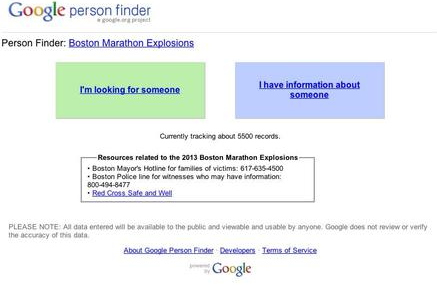
Another example is how the Google Person Finder was used again during the Boston Marathon bombings, allowing friends and family to access the database, whether you were looking for someone, or had information about someone. Missing person reports, information from emergency officials and data from site users was compiled to set up the searchable database, available less than one hour after the explosions in Boston. Below, you can view the active webpage that was available post-explosions.
This information is only available until the crisis is over, at which point the Google Server does not allow Internet users to access the database anymore, as seen below. This would be for privacy purposes, as well as to ensure that inaccurate data, or conflicting data from the various sources was not available post-disaster to confuse future Internet searches.

The Google Geospatial Solutions proved to be at the forefront of technology, while ensuring that it will be compatible with previous forms of technology. With global Internet usage continuing to rise, it is essential that such methods are investigated and implemented. I also believe that such geospatial advancements need to be explained to the general public so that they are aware of the capabilities and how user-friendly these systems can be. I, for one, know that my Dad would have no idea that the Google Person Finder exists, never mind how to use it during a crisis. Should a natural or humanitarian disaster occur near me, I know for certain that I will be utilizing the Google Person Finder, and relying on other geospatial solutions it encompasses.


Be the first to comment