
This interview is part of our series on Canada’s infrastructure moment and its impact on the geospatial/geomatics sector.
Canada is preparing to launch the most significant infrastructure investment in recent history — 5% of GDP, with 1.5% carved out for civil preparedness, industrial capacity, and core infrastructure. It’s a moment being called transformative for both infrastructure and geomatics. But is the sector ready?
As part of our national interview series, GoGeomatics is asking industry leaders where we stand — on workforce, innovation, procurement, and sovereignty.
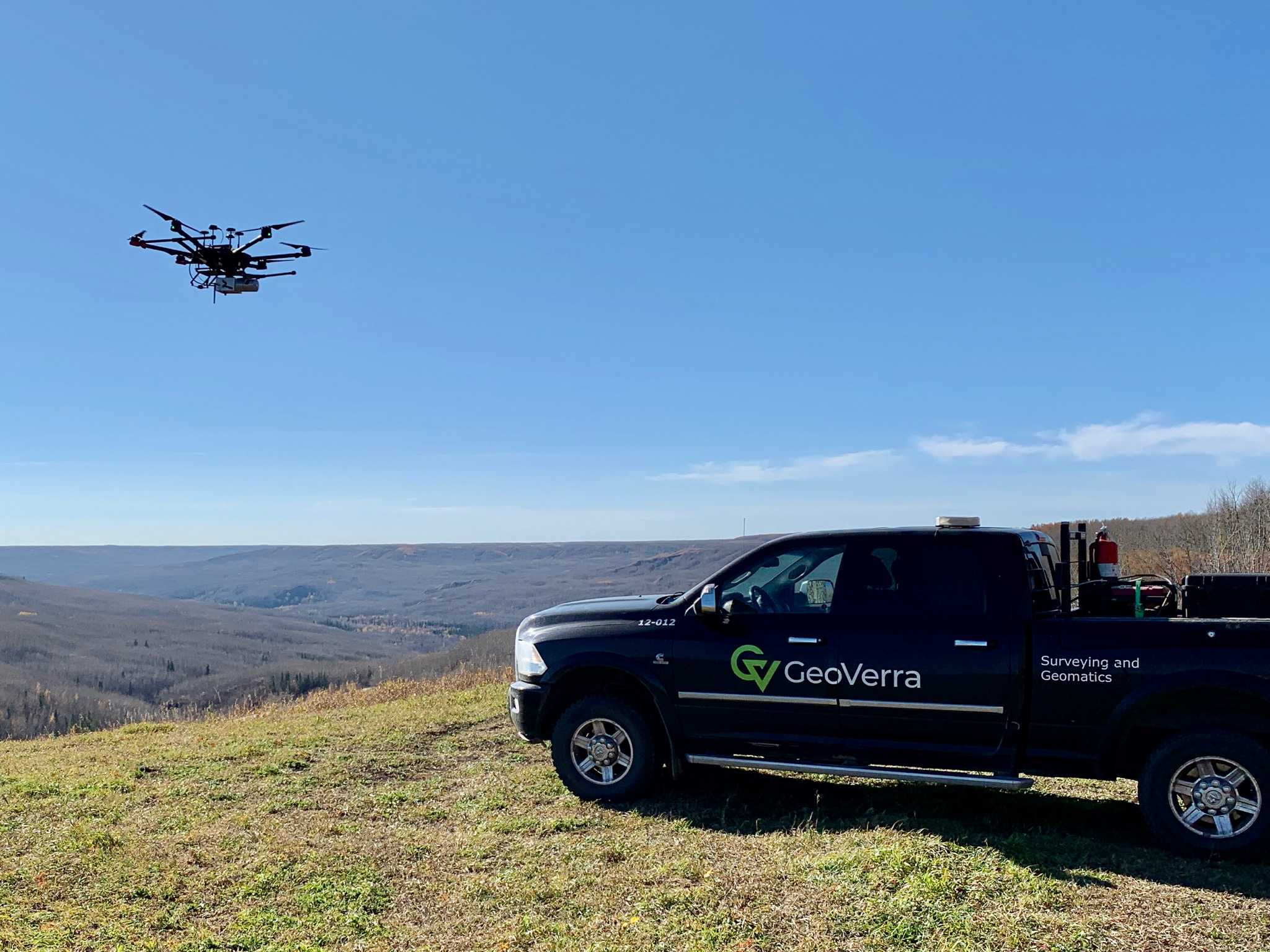
When we put those questions to GeoVerra CEO Mitch Ettinger, his answers were clear: Yes, geopolitics are reshaping how firms think about data control and platform dependencies. And yes, this is the time to push for more sovereign geospatial infrastructure. GeoVerra is one of the largest geomatics firms in the country, providing surveying, mapping, GIS, and geospatial solutions across infrastructure, energy, transportation, and industrial sectors.
From UAVs and LiDAR to regulatory hurdles and workforce bottlenecks, Ettinger walks us through what it will take to deliver on this national agenda — and why geomatics belongs at the center of it.
Do you see this as a nation-building moment for Canada’s infrastructure and geomatics sectors?
There is an opportunity for Canada to build the necessary infrastructure, and geomatics services will be a part of the services provided. The government should embrace innovation in geomatics to improve project outcomes from planning through to construction and operation.
The geomatics industry should work alongside engineers and project sponsors, rather than being contracted through construction companies.
How central is geospatial intelligence to the projects you expect to take on under this plan?
Geospatial intelligence is at the core of our approach and essential to the success of Canada’s transformative infrastructure initiatives. Every major project — from pipelines and power transmission to rail corridors and bridges — relies on accurate spatial data for informed decision-making.
Our comprehensive services, including UAV surveys, Lidar mapping, 3D scanning, GIS platforms, and digital twin development, provide the precision and context needed for planning, design, construction, and lifecycle asset management. This ensures projects are delivered efficiently, safely, and in compliance with environmental and regulatory requirements.
How is your organization preparing for the surge in infrastructure and civil works projects tied to Canada’s infrastructure and defense commitment?
GeoVerra is well-positioned for the surge in projects, as we are one of the largest geomatics companies in Canada, with offices from BC to ON. With expertise in all types of infrastructure projects, we are well-equipped to manage any infrastructure opportunity. Our capacity and depth of skilled resources have allowed GeoVerra to participate in one of Canada’s most significant recently completed infrastructure projects (LNG Canada and Trans Mountain Expansion Pipeline), with up to 60 field crews working per day on the project.
What types of projects is GeoVerra preparing to support under Canada’s infrastructure plan — and what does success look like?
At this stage, as no project has been officially announced, GeoVerra possesses the skills and experience required for all types of projects expected under this national agenda. This includes transmission pipelines, export facilities, transportation, rail, renewable energy, industrial infrastructure, and defense infrastructure.
Currently, we are monitoring prospective projects and enquiring with clients. Success for GeoVerra will mean participating in a diverse range of infrastructure projects across various regions of Canada and driving their success through our talented team members and leading-edge technology.
Does the current public procurement model in the country support the kind of long-term, integrated, and collaborative approach this infrastructure plan requires?
Although these infrastructure projects will receive federal government support, most of the potential projects will be built and owned by private investors / companies. We are very familiar with this procurement process, as that is where most of our work comes from, and it is a system that works well.
It is only expected that defense-related infrastructure projects will go through the federal government procurement process. This can be more challenging due to security clearance requirements, but GeoVerra is well-positioned for this as well.
What role do you anticipate technologies like digital twins, Lidar, remote sensing, and AI-based modeling will play in the delivery of Canada’s transformative infrastructure plan?
These technologies will play a pivotal role in driving innovation and efficiency. Lidar and UAV systems provide high-density 3D data for accurate terrain modeling, route optimization, and as-built verification. Remote sensing and thermal imaging offer early detection of environmental and structural risks across large, complex sites. Digital twins will enable real-time monitoring, predictive maintenance, and simulation for improved resilience and cost control.
Meanwhile, AI-based modeling will accelerate data processing and enhance predictive analytics, helping to anticipate issues such as geohazards, material degradation, and environmental changes. Together, these tools enable faster, smarter, and more sustainable infrastructure delivery.
How are you preparing to integrate these tools into upcoming projects?
We have already embedded these technologies into our standard workflows and continue to scale their use across disciplines. Our teams leverage UAV-Lidar systems, GIS-BIM integration platforms, and cloud-based web portals for real-time data sharing with clients and stakeholders.
Professional development is a priority: our staff participates in specialized training, industry conferences, and certifications to ensure expertise remains current with emerging tools and best practices. Additionally, we maintain flexible workflows that allow rapid adoption of new technologies, ensuring seamless integration with project requirements and client expectations.
Is your organization investing in or partnering on new technologies to support more efficient, resilient, or scalable infrastructure delivery?
While our primary focus is on deploying state-of-the-art hardware and software for surveying, mapping, and modeling, we actively engage with leading technology providers to pilot new solutions and enhance our service capabilities. We also collaborate with academic institutions and attend industry research forums to stay connected to innovation trends in AI, digital twins, and cloud-based geospatial systems. This commitment, combined with our skilled workforce and strong technical foundation, positions us to deliver scalable and future-ready geospatial solutions that align with Canada’s infrastructure goals.
There’s a growing sense within the industry that Canadian-developed technologies and solutions are often undervalued — with foreign providers prioritized even when local options meet or exceed technical requirements. Have you encountered this?
The geomatics technology we utilize (eg. UAVs, RTK, Laser Scanners, Mobile Scanners), is primarily foreign developed technology and software. We work with Canadian resellers and distributors to acquire the equipment/sensors, and they also provide us with training and technical assistance.
There are limited or no Canadian options that meet or exceed the technical requirements for our work. However, it is the utilization and understanding of these technologies, and leveraging their data collection power to turn them into deliverables that meet or exceed client expectations, that is key.
This is where GeoVerra has team members who are leading experts in their field and are invited to international conferences to present their knowledge of taking the technology to the next level. GeoVerra is also closely tied to the Canadian tech industry, through startups and various geomatics University programs, and continually investigates new technologies developed by Canadians.
What are the biggest challenges you foresee in delivering on Canada’s infrastructure goals — whether logistical, regulatory, or operational?
Regulatory challenges will be the biggest challenge. Although Bill C-5 intends to accelerate the timelines for approval, this will be challenging. Through our experience with these large-scale infrastructure projects, we have observed that the preliminary planning, consultation, and approval process can take a decade or more. Accelerating this timeline will not come without legal challenges from various interest groups.
It will be interesting to see how the government navigates this path and meets the time window requirements under Bill C-5. There are a variety of potential projects that are “shovel-ready” or nearly so, so we expect the focus will be on those projects as a priority.
Workforce availability remains a major constraint in the geomatics and construction sectors. Are you experiencing challenges in this area?
In certain regions, yes. Hiring trained, experienced field personnel, especially in major centres, has been a challenge. We’ve responded by increasing our internal training efforts and focusing on professional development. Offering wages above industry standards has also been important in helping us attract and retain the talent needed to meet growing infrastructure demands.
Canada’s NOC system focuses heavily on traditional roles, failing to reflect the broader mix of digital, analytical, and spatial skills that define today’s geospatial workforce. How does this outdated classification affect everything from program funding to labour market planning — and what needs to change?
We have post-secondary programs closing because of a lack of enrollment and underfunding. Canada needs a coordinated strategy to align labour market requirements, education and training programs, immigration, and R&D funding.


Be the first to comment