Migrating breeding populations of Canada warbler clogged by geolocators
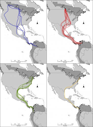
To determine migratory routes of multiple breeding populations of Canada Warblers, scientists from the University of Manitoba directly tracked individuals using light-level geolocators from Migrate Technology Ltd. all weighed less than 5% of the bird’s total body mass including harnesses were worn by captured birds from four sites across the breeding range in Alberta, Manitoba and Québec, Canada, and New Hampshire, USA.
Individuals from all breeding populations took a western fall migration route at the Gulf of Mexico; with 77.8% of birds funnelling into a narrow geographic space along the western side of the Gulf of Mexico.
Most individuals overwintered in Colombia. The remaining individuals overwintered in Venezuela.

https://bmczool.biomedcentral.com/track/pdf/10.1186/s40850-020-00056-4
Young Black Entrepreneur launch a Canadian platform to collect data & give a voice to vulnerable communities during COVID-19
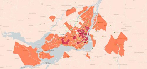
A new platform, Colors of COVID surveys Canadian minority communities in hope to find out the impacts of COVID-19. Thierry Lindor believe that, “we have to acknowledge people’s experiences; especially marginalized experiences. These realities are essentially information. Information is data, data can be converted into knowledge & knowledge – during a pandemic like COVID-19 – can save lives.”
Before and After of Canada’s Rocky Mountain Forests
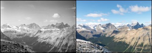
Using century-old surveying photos, scientists from the Mountain Legacy Project have mapped 100 years of change in the Canadian Rockies to document the climate-altered landscape.
Using the technique, known as repeat photography, scientists trekked to summits and vantage points across the Canadian Rockies. Thousands of images have been replicated compared with their counterparts century ago. Tree lines, forest density and glacial recession have shown on photos.

https://www.smithsonianmag.com/science-nature/canadas-rocky-mountain-forests-are-move-180975571/
Survey123 Allowing For Paperless Fish Health Reporting
Survery123 has allowed MOWI, an aquaculture company, to replace paper forms for reports and public licenses and become paperless. Data can be collected from various remote locations and be standardized and analyzed when it is being uploaded to the web database when cell coverage allows. Visualization, analysis and management have become much easier and it supports better decision-making.
https://mowi.com/caw/blog/2020/08/11/survey123-allowing-for-paperless-fish-health-reporting/
Concordia’s Institute for Investigative Journalism launches a Canada-wide COVID-19 data project
A cooperative designed to provide free reporting support, maps and audience engagement tools, Project Pandemic, will help Canadian news organizations to inform audiences about the COVID-19 pandemic and its aftermath.
Student reporters and recent graduates from across the country help gather information in support of member news organizations. Quality maps and data analysis have become available to the public.

WSP & Altus Group announce the launch of GeoVerra, a leading geomatics firm in Western Canada and Ontario
WSP Global Inc., one of the world’s leading professional services firms and Altus Group Limited, a leading provider of software, data solutions and independent advisory services to the global commercial real estate industry, announced today that a combined entity launched as GeoVerra Inc., providing land surveying, forestry, and geospatial solutions to clients in diverse industries.


Be the first to comment