• facebook
  • Twitter
  • Linkedin
  • Youtube
  • Linkedin Group
  • Post a Job
  • Post an Ad
  • Post an Event
  • Post a Directory Listing
  • Post a Press Release
  • Media Kit
  • My Account
  • Login
GoGeomatics
  • MAGAZINE
    • BIM & GIS
    • Community
    • Conference news
    • Earth Observation
    • Education & Careers
    • GEOAI
    • Announcements
    • Reality Capture & Lidar
    • Science
    • Technology
    • Between the Poles
  • Directories
    • ASSOCIATION
    • INDUSTRY
    • EDUCATION
    • Open Data
  • EVENTS
    • GeoIgnite Events
    • Events Calendar
    • GoGeomatics Meetups
  • Services
    • Advertising
    • Marketing
    • Post a Job
    • Post an Ad
    • Post an Event
    • Post a Press Release
    • Post a Directory Listing
    • Media Kit
    • Web Design
  • Find a Job
  • Volunteer
    • Start a GoGeomatics Group
    • Editors & Writers Group
  • About Us
    • About Us
    • Contact Us
    • Frequently Asked Questions
  • Videos
Home2013August

Month: August 2013

Between the Poles – The Geoff Zeiss Archives

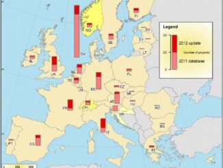
European smart grid project database tracks 281 smart grid projects

9 August 2013 Geoff Zeiss

In 2011, the European Commision’s Joint Reserach Centre (JRC) initiated a comprehensive inventory of smart grid projects in Europe to collect lessons learned and assess smart grid projects in the 27 Member States of the […]

Between the Poles – The Geoff Zeiss Archives

Draft NSDI strategic plan made available by the Federal Geographic Data Committee

8 August 2013 Geoff Zeiss

The Federal Geographic Data Committee (FGDC) has initiated a process to develop a new strategic plan for the National Spatial Data Infrastructure (NSDI) that includes a set of goals and objectives for the continued and […]

No Picture
Access to Spatial Data

Orange County parcel file now freely downloadable

7 August 2013 Geoff Zeiss

I blogged previously about a court case involving Orange County in California about open access to county GIS data under California’s Public Records Acts (PRA).  After trying to obtain Orange County’s parcel file at the […]

MacKinnon Carto2013 Open Data Talk
Technology

The Evolution of Canadian Data Collection and Distribution

7 August 2013 T Mackinnon | aerial

One thing I am sure that almost anybody in geomatics would agree with is that major components of any geospatial projects is the data and, like most things in our society, tend to evolve over […]

Between the Poles – The Geoff Zeiss Archives

OGC GeoPackage draft standard for sharing spatial data released for public comment

6 August 2013 Geoff Zeiss

The Open Geospatial Consortium (OGC) has releases a candidate OGC GeoPackage (GPKG) Standard or public commment. The GPKG Standards Working Group (SWG) will consider all submitted comments for a final draft of the GeoPackage Standard. […]

Between the Poles – The Geoff Zeiss Archives

Solar PV farm in every Thai village

6 August 2013 Geoff Zeiss

According to the Bangkok Post, the Thai Finance Ministry plans to spend 80 billion baht (US$2.5 billion) to set up a one MW solar PV  farm in every village.  There are nearly 75,000 villages in […]

No Picture
3D data

LIght-weight UAV-mounted laser scanning system announced

6 August 2013 Geoff Zeiss

Phoenix Aerial Systems has announced a UAV-mounted LiDAR platform weighing less than 10kg.  The new LiDAR platform called the “Phoenix AL-2” combines UAV, LiDAR and GNSS technology and is designed asa micro-mapping solution. The Phoenix […]

||
Community

Should we be called geomatics or something else?

6 August 2013 Robert Ryerson | ACRS

In order to determine whether geomatics is the most appropriate term for this field it may be useful to review some history. In the mid-1980s the various sub-disciplines of what is now called geomatics, consisting […]

Posts pagination

« 1 … 3 4 5 »

Events

Apr 22
April 22 - April 23

11th Annual Digitalization & AI in Energy Canada Conference

Apr 27
April 27 - April 30

Welcome to the Canadian Hydrographic Conference 2026

May 3
May 3 @ 8:00 am - May 6 @ 5:00 pm

GEOINT Symposium 2026

May 11
May 11 @ 8:00 am - May 13 @ 5:00 pm

GeoIgnite 2026

May 25
May 25 - May 28

National Surveyors’ Conference 2026

View Calendar

View All Events

Services

  • Post a Job
  • Post an Ad
  • Post an Event
  • Post a Directory Listing
  • Post a Press Release
  • Media Kit
  • My Account
  • Login

Jobs

Post a Job
  • Junior Geomatics Field Technician – Technical Surveys
    Montréal, QC
  • GIS Specialist
    Amherst, Nova Scotia
  • Precast Structural BIM Specialist
    Calgary, Alberta
  • Precast Structural Project Coordinator (BIM)
    Calgary, Alberta
View All Jobs
  • Directories
    • Associations Directory
    • Industry Directory
    • Education Programs
    • Open Data
  • Volunteer
    • Start a GoGeomatics Group
    • Editors & Writers Group
  • About Us
    • GoGeomatics Media Kit
    • Who We Are
    • Contact Us
    • FAQ’s
    • Advertising
    • Marketing
  • Subscribe
GoGeomatics
GoGeomatics is the largest and most popular communications hub promoting the Canadian geospatial community. The business was incorporated in 2011. GoGeomatics hosts over 100 fun, free, location technology networking events each year in cities across Canada.

© 2026 GoGeomatics

  • facebook
  • Twitter
  • Linkedin
  • Youtube
  • Linkedin Group