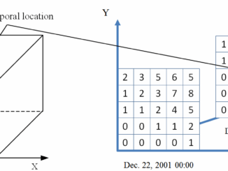
• facebook
  • Twitter
  • Linkedin
  • Youtube
  • Linkedin Group
  • Post a Job
  • Post an Ad
  • Post an Event
  • Post a Directory Listing
  • Post a Press Release
  • Media Kit
  • My Account
  • Login
GoGeomatics
  • MAGAZINE
    • BIM & GIS
    • Community
    • Conference news
    • Earth Observation
    • Education & Careers
    • GEOAI
    • Announcements
    • Reality Capture & Lidar
    • Science
    • Technology
    • Between the Poles
  • Directories
    • ASSOCIATION
    • INDUSTRY
    • EDUCATION
    • Open Data
  • EVENTS
    • GeoIgnite Events
    • Events Calendar
    • GoGeomatics Meetups
  • Services
    • Advertising
    • Marketing
    • Post a Job
    • Post an Ad
    • Post an Event
    • Post a Press Release
    • Post a Directory Listing
    • Media Kit
    • Web Design
  • Find a Job
  • Volunteer
    • Start a GoGeomatics Group
    • Editors & Writers Group
  • About Us
    • About Us
    • Contact Us
    • Frequently Asked Questions
  • Videos
Home2016

Year: 2016

3D data

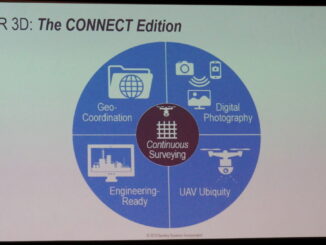
Spar 3D: 3D mapping the inside of multi-story buildings with a backpack

5 May 2016 Geoff Zeiss

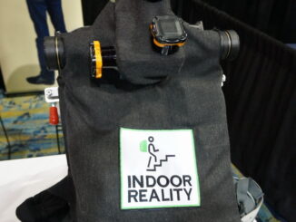
At the Spar 3D Expo and Conference in Houston The Woodlands, Texas, Avideh Zakhor from the University of California Berkeley was onsite with some remarkable products from her new startup Indoor Reality.  I blogged previously […]

Technology

NetCDF: a growing standard for encoding georeferenced data in binary form

5 May 2016 Emmanuel Stefanakis | 2014

Recently, the Open Geospatial Consortium (OGC) has announced an extension to the OGC CF-netCDF 3.0 encoding standard that specifies how Climate and Forecast (CF) netCDF datasets are encoded as OGC coverages. This extended standard facilitates […]

3D data

SPAR2016: Geo-coordination key to convergence of engineering and 3D technology

3 May 2016 Geoff Zeiss

We are seeing the convergence of engineering and architecture with 3D technology and this is enabling a full lifecycle perspective in designing and constructing infrastructure where we not only aim at better project delivery, but […]

Analytics

GeoBuiz 2016: Geospatial and consumer devices, reality modeling, big data and analytics

2 May 2016 Geoff Zeiss

Reality modeling In the future, the deliverables at the end of a construction project will not only include the completed building itself, but also a digital “reality model” of the structure.  The digital model will […]

Between the Poles – The Geoff Zeiss Archives

India adds 7 GW of renewable energy capacity in FY2015-16

1 May 2016 Geoff Zeiss

The Indian Ministry of New and Renewable Energy has reported that India added 6,937 MW of grid-connected renewable energy capacity during FY2015–16, that’s over 2% of  India’s total power generation capacity on 31 March 2016 […]

Access to Spatial Data

GeoBuiz 2016: High volume geospatial imagery processing requires new architecture

29 April 2016 Geoff Zeiss

DigitalGlobe owns and operates a constellation of commercial earth observation satellites.  The latest is Worldview-3 which is capable of about 30 cm precision.  Digital Globe’s satellites collect 3,000,000 square kilometers of Earth imagery every day, […]

No Picture
Newsmakers & Press Releases

JMap provides instant access to all of the Canadian railway network’s geospatial data

27 April 2016 GoGeomatics Newsmakers | analysis

K2 Geospatial, a leading geospatial software company and the editor of JMap, is pleased to announce the creation of the Canadian Rail Portal. Initiated by the Railway Association of Canada (RAC), the Portal was built […]

|||||||||
Community

GoGeomatics Goes to East Africa: New Markets for Canadian Technologies

27 April 2016 Jon Murphy | 2012

  Jambo from Nairobi, Kenya!   I,  Jon Murphy – GoGeomatic’s intrepid Managing Director, am in Kenya having a look at how Canadian geomatics technology is being deployed in East Africa. The G-Locate team in […]

Posts pagination

« 1 … 22 23 24 … 34 »

Events

Notice
There are no upcoming events.

View All Events

Services

  • Post a Job
  • Post an Ad
  • Post an Event
  • Post a Directory Listing
  • Post a Press Release
  • Media Kit
  • My Account
  • Login

Jobs

Post a Job
  • Volunteer Editorial Contributor – Be Part of Canada’s Geomatics Story
    Remote
  • Junior Geomatics Field Technician – Technical Surveys
    Montréal, QC
  • GIS Specialist
    Amherst, Nova Scotia
  • Precast Structural BIM Specialist
    Calgary, Alberta
View All Jobs
  • Directories
    • Associations Directory
    • Industry Directory
    • Education Programs
    • Open Data
  • Volunteer
    • Start a GoGeomatics Group
    • Editors & Writers Group
  • About Us
    • GoGeomatics Media Kit
    • Who We Are
    • Contact Us
    • FAQ’s
    • Advertising
    • Marketing
  • Subscribe
GoGeomatics
GoGeomatics is the largest and most popular communications hub promoting the Canadian geospatial community. The business was incorporated in 2011. GoGeomatics hosts over 100 fun, free, location technology networking events each year in cities across Canada.

© 2026 GoGeomatics

  • facebook
  • Twitter
  • Linkedin
  • Youtube
  • Linkedin Group