
Recently, the Open Geospatial Consortium (OGC) has announced an extension to the OGC CF-netCDF 3.0 encoding standard that specifies how Climate and Forecast (CF) netCDF datasets are encoded as OGC coverages. This extended standard facilitates the use of complex environmental data in GIS and other geospatial systems and it is another action taken by OGC in the last few years towards the integration of netCDF into geospatial technology.
NetCDF (Network Common Data Form) is a set of software libraries and formats that support the creation, access, and sharing of many kinds of scientific data. Originally developed for the Earth science community (Unidata Program Centre at the University Corporation for Atmospheric Research, URAC) in 1989, it is particularly well suited to encoding multidimensional array-oriented scientific data. NetCDF formats are self-describing and platform independent, while a wide range of interfaces, libraries, and applications have been developed around them, similarly to the XML family of technologies built around XML.
Atmospheric and ocean scientists have been using netCDF for long time to encode space- and time- varying data in forms of related arrays. NetCDF datasets are able to describe the behaviour of continuous phenomena through a set of parameters such as air pressure, precipitation, air temperature, water salinity, or wind speed in the 4-dimensional space-time (three dimensions X,Y,Z for space and one dimension T for time). This is accomplished via a grid of discrete points within the mathematical function space. Example data collections encoded in netCDF include the output of weather and climate forecast models, weather stations and ocean buoy observations, balloon soundings, digital elevation models, satellite imagery, and Lidar point clouds.
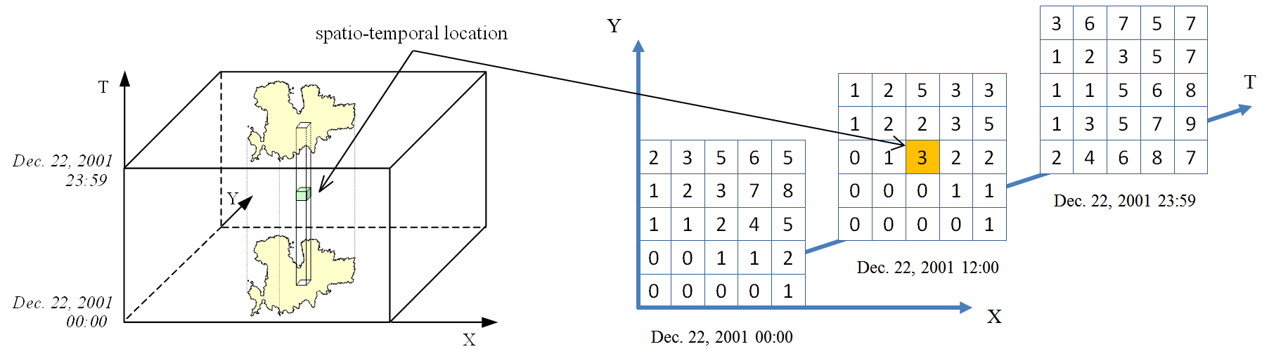
Figure 1. The data in a netCDF file is stored in the form of arrays. Variation of precipitation over time (three-dimensional data: data over an area X,Y varying with time T).
NetCDF has been formally recognized by US Government standards bodies, including NASA and NOAA, while OGC and UCAR have been working closely since 2009 to get netCDF recognized as an international standard for encoding georeferenced data in binary form. This way, the interoperability among clients and servers interchanging data in binary form will be facilitated. OGC and UCAR are considering both the extensions to the core netCDF standard and extensions to other OGC standards that specify netCDF encoding.
A series of OGC netCDF standards developed so far have made possible the delivery of scientific data in digital form via OGC protocols, such as GML, WCS, WFS, and OWS. These standards and those to come will definitely increase the accessibility and usability of large collections of environmental netCDF data and associated libraries and interfaces by the broad OGC community, including non-experts, with multiple benefits for geospatial research and development.
Further Reading
Domenico, B., and Nativi, S., 2014. OGC netCDF: Powerful Tool for Science. Earthzine. http://earthzine.org/2014/03/14/ogc-netcdf-powerful-tool-for-science/ [Visited April 29, 2016]
OGC, 2016. OGC network Common Data Form (netCDF) standards suite. http://www.opengeospatial.org/standards/netcdf [Visited April 29, 2016]
OGC, 2015. OGC announces standard that makes complex environmental data easier to use in GIS. http://www.opengeospatial.org/pressroom/pressreleases/2341 [Visited April 29, 2016]
OGC, 2014. NetCDF SWG. http://www.opengeospatial.org/projects/groups/netcdfswg [Visited April 29, 2016]
Unidata, 2016. Network Common Data Form (NetCDF) http://www.unidata.ucar.edu/software/netcdf/ [Visited April 29, 2016]
Wikipedia, 2016. NetCDF https://en.wikipedia.org/wiki/NetCDF [Visited April 29, 2016]


Be the first to comment