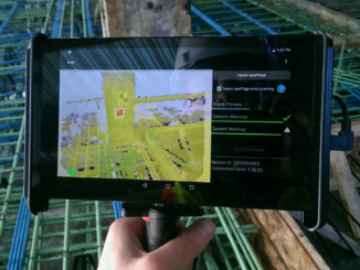
• facebook
  • Twitter
  • Linkedin
  • Youtube
  • Linkedin Group
  • Post a Job
  • Post an Ad
  • Post an Event
  • Post a Directory Listing
  • Post a Press Release
  • Media Kit
  • My Account
  • Login
GoGeomatics
  • MAGAZINE
    • BIM & GIS
    • Community
    • Conference news
    • Earth Observation
    • Education & Careers
    • GEOAI
    • Announcements
    • Reality Capture & Lidar
    • Science
    • Technology
    • Between the Poles
  • Directories
    • ASSOCIATION
    • INDUSTRY
    • EDUCATION
    • Open Data
  • EVENTS
    • GeoIgnite Events
    • Events Calendar
    • GoGeomatics Meetups
  • Services
    • Advertising
    • Marketing
    • Post a Job
    • Post an Ad
    • Post an Event
    • Post a Press Release
    • Post a Directory Listing
    • Media Kit
    • Web Design
  • Find a Job
  • Volunteer
    • Start a GoGeomatics Group
    • Editors & Writers Group
  • About Us
    • About Us
    • Contact Us
    • Frequently Asked Questions
  • Videos
Home2017

Year: 2017

3D Visualization

Mixed reality in the construction industry is becoming a reality

13 April 2017 Geoff Zeiss

At the SPAR3D 2017 conference in Houston, I had the distinct feeling that we are on the cusp of an important inflection point where technology has evolved to the point that it is going to […]

Between the Poles – The Geoff Zeiss Archives

New standard for locating underground infrastructure launched

12 April 2017 Geoff Zeiss

The new PAS 256 standard “Buried services – Collection, recording and sharing of location information  data“, which complements the existing PAS 128 standard, was launched last night at the Institution of Civil Engineers in London.  […]

|||||||||||||||
Technology

UAV Surveys – How to Ensure Accuracy and Precision

12 April 2017 Thomas Hoppe | accuracy

For the past four years, I’ve been involved with the capture and delivery of data derived from drones. My experience has provided me with a good perspective on the quality of the data that can be […]

3D data

Handheld 3D scanners rapidly approaching consumer pricing

11 April 2017 Geoff Zeiss

I have just spent an incredible three days in Houston at the SPAR3D 2017 conference.  There is so much going on right now in the 3D world with several key technologies just coming to fruition […]

||
Newsmakers & Press Releases

Association of Canada Lands Surveyors Develops New Canadian Hydrographer Certification

11 April 2017 GoGeomatics Newsmakers | 2016

Canadian Hydrographer Certification Scheme Association of Canada Lands Surveyors The Association of Canada Lands Surveyors (ACLS) has developed a certification model for hydrographers and offshore surveyors which has been officially recognized by the IHO/FIG/ICA International […]

||||||
Technology

Free Satellite Imagery For You: Sentinel 1 & 2

7 April 2017 Muhammad Luqman | 2017

Sentinel constellations and data products As the ENVISAT program is coming to an end, the European Space Agency has begun the process to develop the Sentinels family of satellites to fulfill the Copernicus earth observation […]

3D data

Autonomous UAVs using SLAM to navigate without GPS

6 April 2017 Geoff Zeiss

I have just spent an incredible three days in Houston at the SPAR3D 2017 conference.  There is so much going on right now in the 3D world with several key technologies just coming to fruition […]

||||||||||||||||||||||||||
Community

Event in Pictures: COGS Industry Expo 2017

5 April 2017 Richard Davenport | 2017

The College of Geographic Sciences (COGS) held the 2017 COGS Industry Expo on March 23 in Lawrencetown, Nova Scotia. COGS has a long-standing tradition of hosting an annual career fair and inviting industry professionals to […]

Posts pagination

« 1 … 15 16 17 … 28 »

Events

Notice
There are no upcoming events.

View All Events

Services

  • Post a Job
  • Post an Ad
  • Post an Event
  • Post a Directory Listing
  • Post a Press Release
  • Media Kit
  • My Account
  • Login

Jobs

Post a Job
  • Volunteer Editorial Contributor – Be Part of Canada’s Geomatics Story
    Remote
  • Junior Geomatics Field Technician – Technical Surveys
    Montréal, QC
  • GIS Specialist
    Amherst, Nova Scotia
  • Precast Structural BIM Specialist
    Calgary, Alberta
View All Jobs
  • Directories
    • Associations Directory
    • Industry Directory
    • Education Programs
    • Open Data
  • Volunteer
    • Start a GoGeomatics Group
    • Editors & Writers Group
  • About Us
    • GoGeomatics Media Kit
    • Who We Are
    • Contact Us
    • FAQ’s
    • Advertising
    • Marketing
  • Subscribe
GoGeomatics
GoGeomatics is the largest and most popular communications hub promoting the Canadian geospatial community. The business was incorporated in 2011. GoGeomatics hosts over 100 fun, free, location technology networking events each year in cities across Canada.

© 2026 GoGeomatics

  • facebook
  • Twitter
  • Linkedin
  • Youtube
  • Linkedin Group