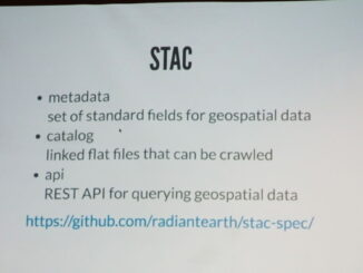
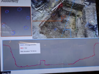
||
Technology

Your Global Geospatial Briefing for May 21: $20M in Contracts for Deimos; Apple Drone Concerns; LocationSmart Data Leak; Sentinel 3-B First Images; U.S. Military Investigates Metadata Tampering; Telenav’s Open-Source AI; Interview with ESRI on Smart Cities

Contracts of over $20M for Deimos Imagery For the first time, the General Services Administration (GSA) has awarded a Multiple Award Schedule to a European company in Earth observation: Deimos Imaging, subsidiary of Urthecast. Deimos […]

3D data

Virtual reference networks workshop

Speaker lineup Virtual Reference Networks Canadian Geodetic Survey Tools and Services for Accurate PositioningBrian Donahue, Geodetic Survey Division, Natural Resources Canada TopNET Live – GNSS Survey Grade Corrections Where and When You WantJonathon Ball, Infrastructure […]