• facebook
  • Twitter
  • Linkedin
  • Youtube
  • Linkedin Group
  • Post a Job
  • Post an Ad
  • Post an Event
  • Post a Directory Listing
  • Post a Press Release
  • Media Kit
  • My Account
  • Login
GoGeomatics
  • MAGAZINE
    • BIM & GIS
    • Community
    • Conference news
    • Earth Observation
    • Education & Careers
    • GEOAI
    • Announcements
    • Reality Capture & Lidar
    • Science
    • Technology
    • Between the Poles
  • Directories
    • ASSOCIATION
    • INDUSTRY
    • EDUCATION
    • Open Data
  • EVENTS
    • GeoIgnite Events
    • Events Calendar
    • GoGeomatics Meetups
  • Services
    • Advertising
    • Marketing
    • Post a Job
    • Post an Ad
    • Post an Event
    • Post a Press Release
    • Post a Directory Listing
    • Media Kit
    • Web Design
  • Find a Job
  • Volunteer
    • Start a GoGeomatics Group
    • Editors & Writers Group
  • About Us
    • About Us
    • Contact Us
    • Frequently Asked Questions
  • Videos
Home2018June

Month: June 2018

3D data

Singapore plans 3D map of underground infrastructure

29 June 2018 Geoff Zeiss

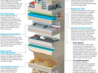
Straits Times According to the Straits Times the Urban Redevelopment Authority (URA) of Singapore intends to release pilot areas of a masterplan of Singapore’s subsurface infrastructure in 2019.​ It will be released as part of […]

No Picture
Between the Poles – The Geoff Zeiss Archives

Initiative to create digital twin linking above- and belowground infrastructure

28 June 2018 Geoff Zeiss

Combining above and below-ground information into one national single data model/data exchange framework will allow industry to share business developments and innovation activities.  Project Iceberg is an exploratory project undertaken by the British Geological Survey, […]

|||||||
Technology

Tarin’s Kim Koons discusses future of the geospatial data business in Canada

28 June 2018 Jon Murphy | aerial imagery services

A GIS is not much use without the data.  GoGeomatics turns our attention to Tarin Resource Services in order to share another Canadian geospatial success story. We welcome Kim Koons co-owner of Tarin a leading […]

|||||
Newsmakers & Press Releases

Earth Observation: find, store, analyze and process GIS data within a single EOS platform

27 June 2018 Earth Observing System (EOS) | cloud

Most image analysis tasks can now run online thanks to EOS Platform, a new cloud service by EOS Data Analytics for search, analysis, storing, and visualization of geospatial data. With EOS Platform you get access […]

Between the Poles – The Geoff Zeiss Archives

Bentley delivers web-based open source geospatial front-end to leading road and rail asset management system

25 June 2018 Geoff Zeiss

I blogged over a year ago about Bentley’s support for the open source Cesium 3D globe project.  Even so I was surprised to see a Bentley Systems booth at FOSS4GNA is St Louis.  Luckily I […]

|||||
Technology

Your Canadian Geospatial Briefing for June 25th: Canadian GIS Program Closing; Arctic Coast Guard; Canadian Gov’t and Big Data; Radarsat Satellites; flood imagery; Investing in Canada Plan

25 June 2018 GoGeomatics Canada | Arctic

Why is Red River College closing its GIS program? “Low Industry and labour market demand and difficulty attracting students” as well as budget costs to post-secondary schools in Manitoba have been cited as causes in […]

No Picture
3D Visualization

British guidelines for BIM targeting 33% savings in TOTEX to become international ISO standards

23 June 2018 Geoff Zeiss

The BS 1192 suite of guidelines and best practices developed under the auspices of the BSI, the national standards body of the UK, are designed to help the UK construction industry adopt BIM Level 2 […]

Between the Poles – The Geoff Zeiss Archives

Application of geospatial deep learning to real world problems accelerating

22 June 2018 Geoff Zeiss

Deep learning is increasingly finding practical applications using geospatial data, specifically, satellite imagery. At HxGNLIve in Las Vegas, Wim Bozelie, Technology Director at Imagem, described some very practical cases in which machine learning, specifically, convolutional […]

Posts pagination

1 2 … 4 »

Events

Mar 10
March 10 - March 13

2026 ABCLS Conference and 121st Annual General Meeting

Mar 18
6:30 pm - 8:30 pm

Vancouver GoGeomatics Meetup

Mar 24
6:00 pm - 7:30 pm

GIS Industry and Information Night at Algonquin College

Mar 24
6:00 pm - 8:00 pm

Calgary GoGeomatics March Social

Mar 30
7:00 pm - 9:30 pm

Toronto GoGeomatics March Networking Social

View Calendar

View All Events

Services

  • Post a Job
  • Post an Ad
  • Post an Event
  • Post a Directory Listing
  • Post a Press Release
  • Media Kit
  • My Account
  • Login

Jobs

Post a Job
  • Operations Spatial Data Assistant (Contract)
    Vaughan
  • GIS Analyst
    Saint John, New Brunswick
  • GIS Student Intern
    Elmsdale, Nova Scotia
  • Canada Impact+ Research Chair – Professor (Or Associate Professor)
    Lethbridge, Alberta
View All Jobs
  • Directories
    • Associations Directory
    • Industry Directory
    • Education Programs
    • Open Data
  • Volunteer
    • Start a GoGeomatics Group
    • Editors & Writers Group
  • About Us
    • GoGeomatics Media Kit
    • Who We Are
    • Contact Us
    • FAQ’s
    • Advertising
    • Marketing
  • Subscribe
GoGeomatics
GoGeomatics is the largest and most popular communications hub promoting the Canadian geospatial community. The business was incorporated in 2011. GoGeomatics hosts over 100 fun, free, location technology networking events each year in cities across Canada.

© 2026 GoGeomatics

  • facebook
  • Twitter
  • Linkedin
  • Youtube
  • Linkedin Group