
Why is Red River College closing its GIS program?
“Low Industry and labour market demand and difficulty attracting students” as well as budget costs to post-secondary schools in Manitoba have been cited as causes in the closing of three programs at Red River College and the layoff of several staff members.
MGUG Education and Co-director Steven Hills worries that students and prospective GIS employees will be left without the basic tools for starting out in the geospatial industry, diminishing longer term workforces and decreasing the ability of student graduated to assist organizations.
New tech saves connectivity in the Arctic
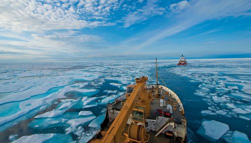
Operating without adequate communication tools in the Arctic is arguably more dangerous than anywhere else in the world. Current communication capabilities are drastically sub-standard: limited cell phone connection, difficult data transmission, the low Earth-orbit Iridium Communications constellation, and a system of communications satellites not yet available to the Coast Guard, according to a 2018 Homeland Security Operational Analysis Center report.
That’s why the Coast Guard is pursuing efforts to build a “robust cyber-secure network” using two Polar Scout Spacecraft satellites, a potential CubeStat technology road-map, and a new technique called ‘quantum illumination’ for increasing situational awareness in the Arctic.
Trudeau Government prepares for the coming of Big Data
The Minister for Economic Development Navdeep Bains has sent out invitations to a launch for national digital and data consultations in response to overwhelming requests from business leaders and academics to establish a national strategy for Canada’s increasingly data-driven economy. Eager to harness the power of Artificial Intelligence and big data to create jobs and economic opportunities, the government is also under pressure to generate policy that will answer security and personal privacy concerns. To this end, their federal invitation was extended to industry experts including the Council of Canadian Innovators. Scrutiny of data-giants like Facebook and Google is taking place as policy-makers try to decide how data should be collected, stored and used by corporate bodies.
Google Executive and head of public policy Colin McKay says: “The government has an opportunity to create a nuanced strategy that helps Canada differentiate itself from the rest of the world, not just in the tech sector but in health, agriculture, mining, and manufacturing.”
The next generation of Radarsat satellites have possible November launch date

Over the budget and over the deadline, Canada’s Radarsat satellites—originally slated to begin launch in 2014—will finally be carried into orbit by Elon Musk’s company Space X in a Falcon 9 rocket. These new additions to the Radarsat Constellation Mission will orbit the Earth at an altitude of approximately 600 kilometers.
“Maritime surveillance, environmental monitoring, and disaster management,” said Johanna Boshouwers, the general manager of MDA, tasked with building the satellites. “They’re in an orbit that’s moving and between the three of them, they cover the Earth every four days. They’ll cover 90 per cent of the globe over that time.”
University of New Brunswick to help homeowners access imagery of their homes during floods
Researchers led by Shabnam Jabari, a post-doctoral research fellow in geomatics, hope to make satellite images of properties cut off by flooding available during potential disasters, allowing homeowners to view damagr to their houses. Besides allowing those who are cut off from their homes to survey damage at a distance, applications for the process range from insurance, to flood mapping, to informing those who wish to buy property in areas prone to flooding.
Can Canadian Geomatics companies get involved?
Through the Investing in Canada Plan, the government plans to encourage community benefits through infrastructure projects. Recipients of federal funding for new public infrastructure projects must now consider whether their projects will create training and job opportunities for under-represented groups, including newcomers, Indigenous peoples, women, persons with disabilities, veterans, youth, and apprentices. This will also be a requirement for final proposals submitted to the Smart Cities Challenge.
The government of Canada will invest $180 billion over 12 years in public transportation, green and social infrastructure, trade and transportation, and Northern communities.


Be the first to comment