• facebook
  • Twitter
  • Linkedin
  • Youtube
  • Linkedin Group
  • Post a Job
  • Post an Ad
  • Post an Event
  • Post a Directory Listing
  • Post a Press Release
  • Media Kit
  • My Account
  • Login
GoGeomatics
  • MAGAZINE
    • BIM & GIS
    • Community
    • Conference news
    • Earth Observation
    • Education & Careers
    • GEOAI
    • Announcements
    • Reality Capture & Lidar
    • Science
    • Technology
    • Between the Poles
  • Directories
    • ASSOCIATION
    • INDUSTRY
    • EDUCATION
    • Open Data
  • EVENTS
    • GeoIgnite Events
    • Events Calendar
    • GoGeomatics Meetups
  • Services
    • Advertising
    • Marketing
    • Post a Job
    • Post an Ad
    • Post an Event
    • Post a Press Release
    • Post a Directory Listing
    • Media Kit
    • Web Design
  • Find a Job
  • Volunteer
    • Start a GoGeomatics Group
    • Editors & Writers Group
  • About Us
    • About Us
    • Contact Us
    • Frequently Asked Questions
  • Videos
Home2022February

Month: February 2022

||||
Technology

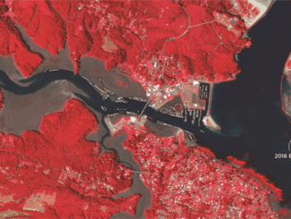
Observing the Peace-Athabasca Delta and Wetland Climate Stress from Space

28 February 2022 Sarah Preston | Conservation

In the far northern reaches of Canada’s Saskatchewan Province, the Athabasca River and Peace River flow into the Peace-Athabasca Delta, the largest boreal delta in the world and home to a variety of diverse habitats […]

Education & Careers

Geospatial Job Hunting Seminar Online March 9th

28 February 2022 Jon Murphy | Canada

Find a GIS Job: Geospatial Career Seminar March 9th, 2022 At this years National Canadian Geospatial Conference, GeoIgnite, Jonathan Murphy will host an event for job seekers looking to navigating the competitive job market. Finding […]

||||||
Technology

International Geospatial Briefing Feb. 28th: 1. Indian government starts work on mapping villages. 2. Scottish space sector charts path to a sustainable future. 3. Five ways AI is saving wildlife. 4. Satellite images show military movements by Russia. 5. Underground Railroad secrets revealed with drones, lasers and radar. 6. NASA ‘NACHOS’ Instrument May Help Predict Volcanic Eruptions.

28 February 2022 GoGeomatics Canada | Archaeology GIS

Indian Government starts work on mapping villages The Indian government is using geospatial technology and drones to map six lakh villages and prepare 3D maps of 100 Indian cities. Space minister Jitendra Singh said, “the […]

|
Community

Examining how agriculture is affected by climate

24 February 2022 Sean Heeger | agriculture

Catherine Champagne shares data on how one of the most important sectors is affected by climate Catherine Champagne, acting manager of the National Agroclimate Information Service, is new to the GeoIgnite conference this year, and […]

|
Technology

Examining greenhouse gasses from space

24 February 2022 Sean Heeger | Al Gore

Barbara Ryan to continue discussions held at the UN on research findings In late 2019, Barbara Ryan, executive director of the World Geospatial Industry Council (WGIC), started tracking and mapping three greenhouse gasses from space. […]

Community

GeoIgnite: Winter Geo conference returns for fourth annual run

23 February 2022 Sean Heeger | annual

Climate change is the topic of discussion from March. 1 to 10 The fourth annual conference for the geospatial community, GeoIgnite: Winter Geo, is on from March. 1 to 10. This year, the topic of […]

|
Community

The spark of a keynote presentation at GeoIgnite 2022

22 February 2022 Sean Heeger | Canada

Will Cadell, founder and CEO of Sparkgeo, hosts keynote presentation Will Cadell is the founder and CEO of Sparkgeo, which focuses on providing geospatial expertise. With a focus on earth observation and geospatial analytics, Cadell […]

|||||
Community

Nick Kellett to present research findings at GeoIgnite 2022

22 February 2022 Sean Heeger | Canada

Examining three years of work to combat climate change Since he started appearing at the GeoIgnite conference in 2020, Nick Kellett, founder and CEO of Deploy Solutions, has been discussing climate change. His company’s project […]

Posts pagination

1 2 … 4 »

Events

Feb 19
February 19 - February 22

Spatial Knowledge and Information Canada 2026

Feb 19
February 19 - February 22

SKI Conference Canada 2026

Feb 23
7:00 pm - 9:00 pm

Toronto GoGeomatics Networking Social – February 23, 2026

Feb 24
All day

Digital Leadership Day Federal

Feb 24
February 24 - February 26

Government Innovation Week – Federal

View Calendar

View All Events

Services

  • Post a Job
  • Post an Ad
  • Post an Event
  • Post a Directory Listing
  • Post a Press Release
  • Media Kit
  • My Account
  • Login

Jobs

Post a Job
  • Volunteer Editorial Contributor – Be Part of Canada’s Geomatics Story
    Remote
  • Junior Geomatics Field Technician – Technical Surveys
    Montréal, QC
  • GIS Specialist
    Amherst, Nova Scotia
  • Precast Structural BIM Specialist
    Calgary, Alberta
View All Jobs
  • Directories
    • Associations Directory
    • Industry Directory
    • Education Programs
    • Open Data
  • Volunteer
    • Start a GoGeomatics Group
    • Editors & Writers Group
  • About Us
    • GoGeomatics Media Kit
    • Who We Are
    • Contact Us
    • FAQ’s
    • Advertising
    • Marketing
  • Subscribe
GoGeomatics
GoGeomatics is the largest and most popular communications hub promoting the Canadian geospatial community. The business was incorporated in 2011. GoGeomatics hosts over 100 fun, free, location technology networking events each year in cities across Canada.

© 2026 GoGeomatics

  • facebook
  • Twitter
  • Linkedin
  • Youtube
  • Linkedin Group