• facebook
  • Twitter
  • Linkedin
  • Youtube
  • Linkedin Group
  • Post a Job
  • Post an Ad
  • Post an Event
  • Post a Directory Listing
  • Post a Press Release
  • Media Kit
  • My Account
  • Login
GoGeomatics
  • MAGAZINE
    • BIM & GIS
    • Community
    • Conference news
    • Earth Observation
    • Education & Careers
    • GEOAI
    • Announcements
    • Reality Capture & Lidar
    • Science
    • Technology
  • Directories
    • ASSOCIATION
    • INDUSTRY
    • EDUCATION
    • Open Data
  • EVENTS
    • GeoIgnite Events
    • Events Calendar
    • GoGeomatics Meetups
  • Services
    • Advertising
    • Marketing
    • Post a Job
    • Post an Ad
    • Post an Event
    • Post a Press Release
    • Post a Directory Listing
    • Media Kit
    • Web Design
  • Find a Job
  • Volunteer
    • Start a GoGeomatics Group
    • Editors & Writers Group
  • About Us
    • About Us
    • Contact Us
    • Frequently Asked Questions
  • Videos
Home2025June

Month: June 2025

BIM & GIS

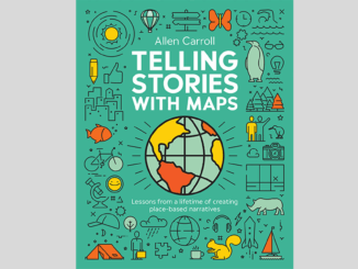
Telling Stories with Maps: Allen Carroll’s Quiet Cartographic Revolution

25 June 2025 Anusuya Datta | Allen Carroll

Maps Are the Medium. Stories Are the Point. Before the software platforms, before the glossy atlases, there’s a photo. A little boy in pajamas sits between his brother and grandmother. Behind them, pinned to the […]

Community

Canadian Geospatial Digest June 23, 2025

23 June 2025 Volunteer Editors and Group Writers | Charter

UBC Okanagan Student Develops Canadian Wildfire Application Flood Mapping will Increase the Number of Quebec Homes in Flood Zones A New Digital Mapping Tool for Ottawa’s Traffic Infrastructure New RFP from the Canada Govt Looks […]

Earth Observation

Europe Moves Toward Satellite Autonomy as U.S. Partnership Grows Uncertain

22 June 2025 Anusuya Datta | Earth Observation

As Europe confronts shifting global alliances, growing defence pressures, and questions about long-term U.S. reliability, its space ambitions are expanding in kind. The European Space Agency (ESA) is now planing its first major dual-use satellite […]

Earth Observation

Earth Observation, Data Access, and Domestic Capacity: Inside CSA’s 2025–26 Plan

22 June 2025 GoGeomatics Canada | Arctic monitoring

The Canadian Space Agency’s latest spending plan maintains steady funding across its core responsibilities, from satellite operations and space science to robotics and international programs. Within that broader mandate, the plan highlights ongoing investment in […]

Reality Capture & Lidar

Ready For a Humanoid Bot in Your Crew?

21 June 2025 Gavin Schrock | AEON

What sets the new AEON humanoid robot apart from the pack, is that it is from a company that develops precision measurement solutions—a name very familiar to the surveying and geomatics sector Mention bots, and […]

co-hosting
BIM & GIS

Growing Together: How Co-Hosted Events Are Uniting Canada’s Geospatial Communities

20 June 2025 GoGeomatics Canada | BIM

At GoGeomatics, we believe Canada’s geospatial future belongs to many voices — not just one. From GIS and BIM to Earth Observation, cartography, open source, and user groups, our sector thrives when communities have space […]

BIM & GIS

Preserving Nature’s Balance: How Prince Edward Island Leads with Environmental Mapping

20 June 2025 Alefiya Dungrawala | Canada

The protection of the environment and wildlife is not merely a moral imperative but a critical necessity for sustaining life on Earth. As human activity accelerates climate change, habitat destruction, and species extinction, the balance […]

Magazine

Turning Strategy into Action on the St. Lawrence: S-100 Sea Trials

20 June 2025 Farzaneh Farshad | bathymetric data

Just a year after unveiling its bold vision for hydro spatial innovation, Canada is turning strategy into action. On June 17, 2025, Fisheries and Oceans Canada officially launched the S-100 Sea Trials on the St. […]

Posts pagination

« 1 2 3 … 5 »

Events

Feb 16
February 16, 2026 @ 8:00 am - February 18, 2026 @ 5:00 pm

GeoWeek 2026

Feb 17
6:00 pm - 8:00 pm

Calgary GoGeomatics February Social

Feb 19
February 19, 2026 - February 22, 2026

Spatial Knowledge and Information Canada 2026

Feb 19
February 19, 2026 - February 22, 2026

SKI Conference Canada 2026

Feb 24
All day

Digital Leadership Day Federal

View Calendar

View All Events

Services

  • Post a Job
  • Post an Ad
  • Post an Event
  • Post a Directory Listing
  • Post a Press Release
  • Media Kit
  • My Account
  • Login

Jobs

Post a Job
  • Canada Maps and Poster Gallery Volunteer Leads — GeoIgnite 2026
    remote
  • GIS & Data Analytics Lead
    Beaumont, AB
  • Lead Surveyor, Projects/Arpenteur-géomètre principal, projets; arpenteuse-géomètre principale, projets
    North Bay, Thunder Bay
  • Senior GIS Developer
    Calgary, AB
View All Jobs
  • Directories
    • Associations Directory
    • Industry Directory
    • Education Programs
    • Open Data
  • Volunteer
    • Start a GoGeomatics Group
    • Editors & Writers Group
  • About Us
    • GoGeomatics Media Kit
    • Who We Are
    • Contact Us
    • FAQ’s
    • Advertising
    • Marketing
  • Subscribe
GoGeomatics
GoGeomatics is the largest and most popular communications hub promoting the Canadian geospatial community. The business was incorporated in 2011. GoGeomatics hosts over 100 fun, free, location technology networking events each year in cities across Canada.

© 2025 GoGeomatics

  • facebook
  • Twitter
  • Linkedin
  • Youtube
  • Linkedin Group