Canadian Geospatial Briefing November 22nd, 2022
- AI aims to prevent a repeat of 2004 Peterborough flood
- City of Medicine Hat Wins 2022 ESRI special achievement in GIS award
- TCS, UofT team up with plan to create ‘urban data sets’ for smart cities
- Canadian space start-up raises $7 Million for hyperspectral imagery
- Targeted grazing: how cows in Canada protect communities from wildfire
AI aims to prevent a repeat of 2004 Peterborough flood
The floods that hit Peterborough, ON in 2004 caused significant damage to property and infrastructure. To prevent such losses again, the city of Peterborough has teamed up with Ecopia AI which is a Toronto-based tech company that uses geospatial data and artificial intelligence (AI) to create high-resolution images of landscapes. Through this effort, information can be gathered to mange and plan for the city’s flood risk. Read More

A High Resolution Imagery (left) which was digitized by Ecopia AI into vector features (right)
City of Medicine Hat Wins 2022 ESRI special achievement in GIS (SAG) award
For the outstanding use of GIS at the city of Medicine Hat, AB through improving asset management with GIS and establishing an integrated GIS strategy for the city, ESRI has awarded the city of Medicine Hat the ESRI special achievement award in GIS (SAG). Read More

Esri Canada President Alex Miller with Nigel Forster, Geospatial Services Superintendent at City of Medicine Hat
TCS, UofT team up with plan to create ‘urban data sets’ for smart cities
One challenge from the rise of Smart Cities is the huge amounts of data that are not managed or governed properly. A collaboration between Tata Consulting Services (TCS) and the Urban Data Centre at the University of Toronto (UofT) is looking to solve this issue by collaboration on Technology to create a catalogue of data sets to allow the discovery of relevant data, where it’s located and identify any restrictions on its use. Read More

Smart City Concept – A More Connected World
Canadian space start-up raises $7 Million for hyperspectral imagery
Adding to the $8 million raised, Wyvern has raised $7 million more for the launch and operations of 3 satellites. Wyvern is aiming to provide hyperspectral imaging from space with Shortwave Infrared (SWIR) technology onboard it’s satellites. Read More
Targeted grazing: how cows in Canada protect communities from wildfire
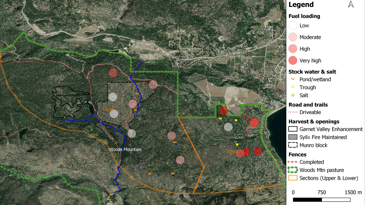
Using GIS technology, a British Columbia pilot program are proving cows can be used to reduced wildfire spread. This is done by directing ranchers to plan their next to grazing plots that have more wildfire fuels. Read More about how GIS is a center piece to this program.

This map shows a gradient of fuel loading at the Peachland Targeted Grazing test plot in July 2021. (Screenshot courtesy of the BC Government)


