Research & Education: Tim Webster on Applied Geomatics Research Group (AGRG)

Dr. Tim Webster
The AGRG, Applied Geomatics Research Group, was formally founded in 2000 by COGS (College of Geographic Sciences) faculty members who saw a need for the region, especially the coastal region, to have applied geomatics research conducted. The principles involved in the founding were Dr.Tim Webster, Dr. Bob Maher (a trusted contributor for GoGeomatics magazine), David Colville, and later joined by Roger Mosher.
Dr. Webster says, “Climate change was becoming an issue, and people were realizing sea-level rise was going to affect this region and we needed to start conducting research to examine the potential impacts.”
At this time, COGS was at full capacity with two buildings under the same administration, one in Lawrencetown and the Annapolis Valley Campus in Middleton. A decision was made, and in January 2000, AGRG was established at the Middleton campus since it had enough space.
In those early days, students who already had undergraduate degrees would graduate from Advanced Diploma programs, such as Remote Sensing or GIS. COGS also offered an Advanced Diploma in GIS-RS, where students took courses from the research scientists, Dr. Webster, Dr. Maher, and Colville. They would conduct a major project before, as Dr. Webster says, “leave and go out into the world.”
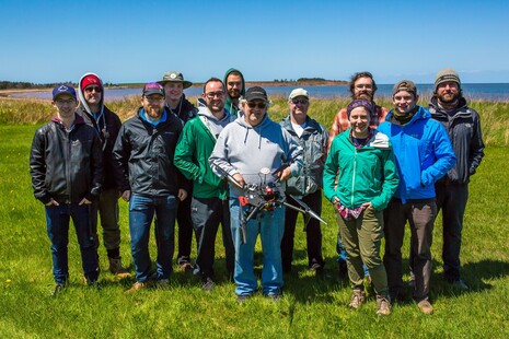
Dr. Tim Webster and COGS students.
The scientists soon realized this style of teaching was not as efficient as it could be. They moved to have Research Associates who were usually recent graduates of COGS, and Research Assistants who were summer students hired to work full-time on projects under the scientists.
Dr. Webster says, “This allowed us to incrementally build expertise and with that have more capacity to conduct research that was at a higher level and at the same time continued to be successful with grant applications for equipment and research.
One of the first Research Associates was Jonathan Murphy, the founder of GoGeomatics Canada. Jon described the importance of the AGRG program for his career and for others. “GoGeomatics Canada would not exist without my early experiences at the AGRG. It allowed me to start using the geo skills I had gained at COGS on important projects with clients. For myself and others the AGRG provided a foundation in GIS, Lidar, remote sensing and applied research that was second to none.”
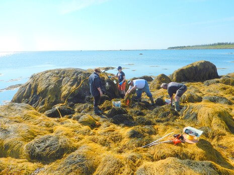
COGS team with rockweed.
Today, 70% of AGRG research is conducted along the coast. Projects include flood risk, near-shore mapping, kelp bed mapping with surveys along the Atlantic Coast in Nova Scotia and the east coast of Newfoundland, modelling land-based pollution, and near-shore oil spills close to tidal inlets. The technology used in these projects includes a Leica topo-bathymetric Lidar equipped with the RCD30 RGB NIR camera, and the MIKE-21 suite of hydrodynamic modelling tools. NSCC is the only Canadian educational institution to have an airborne topography Lidar to our knowledge, which the group obtained through a 2014 CFI grant.
The group has worked with a local company, Acadian Seaplants, that extracts plant additives from rockweed, an intertidal seaweed, to map the biomass of intertidal seaweed. The successful work was published in Botanica Marina. That project led to a $2 million NSERC project where COGS led partner colleges, Holland College, Canada’s Smartest Kitchen, and College of the North Atlantic from Newfoundland and Labrador. The project will use geomatics to improve Marine Spatial Planning and Kelp Assessment and Aquaculture.
The AGRG research team is made up of a lead research scientist, Webster, who has two Research Specialists under him who help manage the projects and research staff. The specialists are Nathan Crowell (who manages the topo-bathy lidar system and much of the field equipment), and Kevin McGuigan who manages the data processing environment. McGuigan has developed several automated routines for processing lidar data and other 3-D and remotely sensed data. AGRG has two permanent Research Associates who focus on hydrodynamic modelling, terrestrial lidar, drone acquisition, and multibeam echo sounding among other tasks. There are six to eight term research associates who work on (government and industry) research contracts and grants.
These grants and contracts are essential for the research to continue. Funding is secured from different sources. Projects have been supported by the Natural Science and Engineering Research Council (NSERC), Social Science and Humanities Research Council (SSHRC), federal departments such as DFO, and partnerships with organizations like NS Salmon Association, Mi’kmaw Conservation Group, and the Unam’ki Institute of Natural Resources.
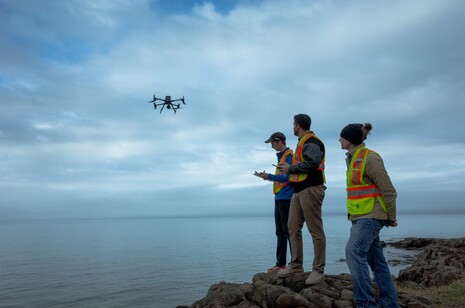
COGS team with drone.
The AGRG has a lengthy list of tools at its disposal. AGRG has a topo-bathy lidar (the group’s most expensive and sophisticated system), among several types of oceanographic instruments, drones (DJI Matrice 6000 with Velodyne lidar, Matrice 300 with L1 lidar, Matrice 100, Mavic, Spark, Splashdrones), multibeam echosounder systems (Teledyne Reson T-20, R2Sonics), ATVss, 3-D printers (DesignJet 660), light and turbidity sensors, several boats multiple Acoustics Doppler Current Profile instruments, a Biosonics single beam sounder, multispectral cameras from RedEdge, and Go Pro cameras and underwater ROVs.
The research of the AGRG is important not only for people in Nova Scotia but all over Canada. The AGRG has worked with several companies to help them utilize lidar technology and visualize flooding, even renting the topo lidar and topo-bathymetric lidar to Leading-Edge Geomatics, a former private company out of New Brunswick.
However, Dr. Webster believes the work around coastal vulnerability and climate change is one of the most important areas of AGRG research (flooding and erosion).
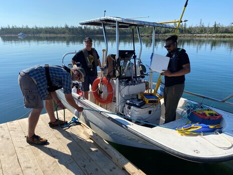
COGS team with one of their uniquely equipped boats.
When Hurricane Fiona made landfall in NS, the Emergency Management Office utilized a web-based flood viewer AGRG developed to show where areas along the Northumberland Shore were going to be impacted by a significant storm surge and to expect flooding and erosion (https://agrgims.cogs.nscc.ca/CoastalFlooding/Map/). Several media interviews were held leading up to the event making landfall, and afterward, the group mapped the damage and collected information.
The AGRG can take a flood event and validate flood models based on observations, then project what the storm could do in the future under climate change and increased sea level conditions.
One of the big impacts of climate change for Atlantic Canada is the expected increase in the sea level. The research allows municipalities to determine areas where building should be restricted and where to place infrastructure.

Dr. Tim Webster and Nathan Crowell prepare to fly.
AGRG is always looking to hire the best person for each project. COGS is a great source of graduating researchers and brings in international students and talent. With less than a decade left before Dr. Webster retires, he has been mentoring Nathan and Kevin to seamlessly take over his role.
Dr. Webster says the future of the AGRG is bright, as it has become the “go-to” institution in the region of geomatics research with an incredible variety of skills available.
He says, “I think the secret to our success is our ability to work with students at COGS to provide them with the latest data and equipment to access, then hopefully keep the best ones as researchers in the group and pay them enough and have opportunities to grow in the future.”


