Canadian Geospatial Digest for April 8th, 2024
- The ‘Nuanced’ Rise and Fall of Canada’s Tree Cover
- Ice cover on the Great Lakes reaches record low
- Crowd-sourced ‘mapping mission’ to rate Ottawa’s accessibility Sunday
- Inaccurate government data may be stoking wildfires
- Ecere Corporation receives OGC Community Impact Award
- If you live in Ottawa and want to see a total eclipse, head for the border
- Vancouver Island University Closes GIS program
The ‘Nuanced’ Rise and Fall of Canada’s Tree Cover
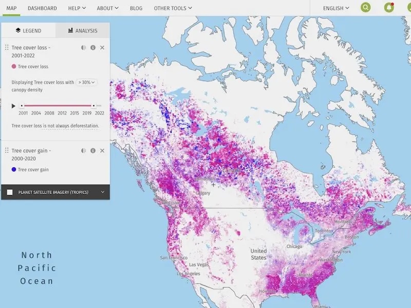
In collaboration with North Arrow, The Energy Mix introduces a monthly map series exploring climate change’s causes and effects. The inaugural map, sourced from Global Forest Watch (GFW), visualizes Canada’s tree cover loss and gain between 2000 and 2022. The map delineates tree loss drivers such as wildfires, forestry, agriculture, and urbanization, highlighting nuances in different regions. Expert commentary underscores the complexity of factors influencing forest loss, including industrial logging practices and their impact on wildfire vulnerability. The maps also illustrate Canada’s net change in tree cover and compare it with the United States over the past two decades. Readers are encouraged to explore the interactive maps on the Global Forest Watch website for comprehensive insights into tree cover dynamics. Read more here.

Ice cover on the Great Lakes reaches record low
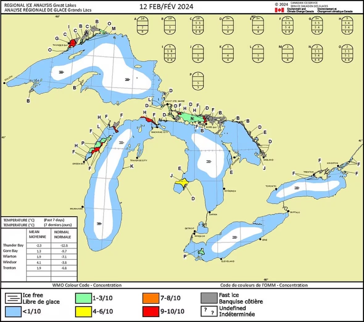
According to Environment and Climate Change Canada, the Great Lakes experienced a record low ice cover this winter due to warmer water temperatures and milder weather, influenced by climate patterns like El Niño and others. Mike McKay, director of the Great Lakes Institute for Environmental Research, notes a 75% decline in ice cover over the past 50 years, particularly in northern lakes like Huron and Superior. While the trend benefits extended shipping seasons, it poses risks to coastal communities, winter activities, and fish spawning. McKay suggests that with ongoing climate change, the decline in ice cover is unlikely to reverse. Read more here.

Crowd-sourced ‘mapping mission’ to rate Ottawa’s accessibility Sunday
Sam Graham and Madeline Turriff, navigating outings with wheelchair accessibility needs, led a crowd-sourced mapping exercise on March 24th to assess Ottawa’s businesses for accessibility. They utilized the AccessNow app, which rates establishments based on accessibility features, aiding in their planning process. The event aimed to expand AccessNow’s coverage in Ottawa, addressing accessibility beyond physical accommodations. While Ottawa scored 53% for accessibility in a 2023 study, improvements are ongoing, with community involvement crucial for accurate mapping and feedback. The event invited individuals to join the mission or contribute independently through the AccessNow app, promoting inclusivity and awareness of accessibility needs in businesses and communities. Read more here.
Inaccurate government data may be stoking wildfires
A study led by the University of British Columbia reveals that inaccurate government data concerning forest fuel loads in British Columbia’s interior could be hindering wildfire fighting and forest management efforts. The study identifies “mismatches” between remotely-sensed mapping, forest fuel classifications, and ground observations, making it challenging for fire managers to accurately predict fire behaviour. Lead author Jen Baron emphasizes the importance of improving fuel-type mapping to aid in identifying and responding to fire-prone areas. The study also uncovers discrepancies between field observations and government data, pointing to the limitations of Canada’s fire behaviour prediction system. While the B.C. government collaborates with researchers to enhance fuel classification and forest inventory data, Baron stresses the need for both aerial and field data to better understand fire behaviour under different conditions. Read more here.
Ecere Corporation receives OGC Community Impact Award
Gatineau’s Ecere Corporation, represented by Jérôme Jacovella-St-Louis, has been awarded the prestigious OGC Community Impact Award by the Open Geospatial Consortium (OGC). This award recognizes Ecere’s exceptional leadership, volunteerism, collaboration, and investment, which have positively influenced the wider geospatial community. Jérôme’s active participation in OGC activities, including Code Sprints and Standards Working Groups, has been instrumental in advancing OGC standards and fostering collaboration within the geospatial domain. As the Co-Chair of five OGC Standards Working Groups and Co-Editor of several standards, Jérôme’s contributions have significantly contributed to the implementation and improvement of OGC standards. Ecere Corporation’s dedication to collaboration and engagement across various OGC initiatives demonstrates their commitment to advancing geospatial technologies and standards. Read more here.

If you live in Ottawa and want to see a total eclipse, head for the border
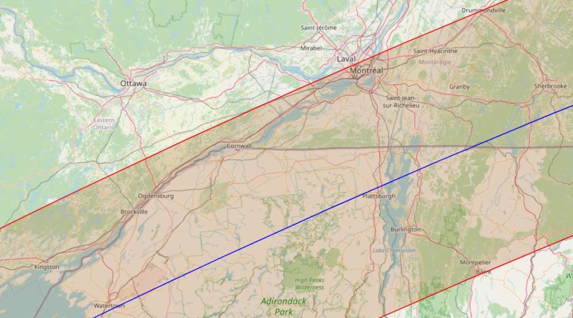
Residents of Eastern Canada hoping to see the total solar eclipse on April 8 are advised to head south to areas within the “path of totality.” While Ottawa will experience a near-total eclipse, only about 99% coverage of the sun is expected, preventing viewers from witnessing phenomena like the solar corona. Kingston and nearby Gananoque are hosting eclipse events, with Kingston offering free transit to viewing locations. Eclipse chaser David Makepeace recommends planning backup locations based on weather forecasts, as areas along the path of totality offer a longer duration of total eclipse. The eclipse path extends into Upstate New York, where communities are preparing for a significant influx of visitors. Watertown, NY, expects its population to multiply by as much as eight times during the event, with preparations including the closure of non-essential operations and the hosting of large-scale viewing events in Thompson Park. Read more here.

Vancouver Island University closes GIS program
Vancouver Island University (VIU) has decided to discontinue four programs after 2024 to better align its offerings with regional needs and support fiscal responsibility. The affected programs include Integrated Engineering Technologist, Online Learning and Teaching, Master in GIS Applications, and Advanced Diploma in Geographic Information Systems (GIS) Applications. The decision comes as VIU works to address declining student enrolments and budget deficits, aiming to return to balanced budgets by 2026-27. Current students in these programs will be supported to graduate, but new enrolments will no longer be accepted. VIU emphasizes its commitment to providing high-quality education and student support amid these changes. Read more here.


