Grand Lake Meadows New Brunswick: Accuracy Comparison of Elevation Datasets
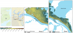
Grand Lake Meadows (GLM), the largest wetland in New Brunswick. GLM is a historically and ecologically significant area which is ecologically diverse and home to an abundance of wildlife, due in part to the extensive floodplains, presiding water levels and the presence of Grand Lake. Given the relatively flat terrain in this area, elevation range of 14m (Figure 1), and recent open access to elevation data, it was of interest to evaluate the accuracy of elevation data available from numerous online sources, including Esri, Google and Bing.
Specifically, the tested elevation data sets offer data through Representational State Transfers (REST) via an application program interface (API). REST is an architectural style for designing networked applications and an API is designed to facilitate interactions or transfers of data across networked computers (Masse, 2011). Though readily available and easy to use, there are certain limitations to the data provided by these services, including: source data often not clearly documented, resolution not clearly reported, and the interpolation method applied for the calculation is unknown (Stefanakis, 2015).
The accuracy of elevation data in the GLM area is analyzed by comparing it to LiDAR data collected in 2014, and available from GeoNB . Of these three datasets, Esri, Google and Bing, the smallest elevation differences were found in the Esri dataset, with 95% of cells being within 2 m of the LiDAR elevations. The Bing dataset was next, with ~89% in the 2 m range, and Google ~80% of the cells in the less than 2 m range, Figure 2. The ease of access and the user-friendly aspect of requesting data from the services vary, with the Bing and Google being found to be most straightforward and well documented. However, the Esri service provided the clearest metadata and source information for the requested elevation data. For more information about this research project, you can view the report written by University of New Brunswick, Geodesy and Geomatics Engineering undergraduate student, Michel Leger

Figure 2 Absolute elevation difference rasters created by subtracting REST elevation API data (a) Bing, (b) Esri and (c) Google from LiDAR data in Grand Lake Meadows
References
Masse, M. (2011). Rest API Design Rulebook: Designing Consistent RESTful Web Service Interfaces. O’Reilly Media, Inc.
Stefanakis, E. (2015, Nov2). Elevation Web Services: Limitations and prospects. GoGeomatics Canada, online Magazine


