
The QGIS User Conference held June 2-3 brought together open-source GIS users and developers at Linköping University in Norrköping, Sweden. The QGIS User Conference is an annual gathering of GIS Professional and other QGIS users to discuss updates, news and other topics about QGIS and open source software broadly. QGIS is an open-source GIS software with a wide range of applications and tools available for its users. While QGIS has a governing hierarchy, much of its development is steered by the grassroots community, which is often represented through national QGIS User Groups.
The QGIS User Conference was full presentations ranging from highly technical plugins and applications to interesting discussions about community events and user groups. Conference-goers had the opportunity to attend various workshops to learn basic and advanced skills. Below are some of the interesting lectures and workshops that I attended during my time at the conference. The QGIS User Conference was large, so this only represents a fraction of what the gathering had to offer. For those that wish to learn more, all presentations from the User Conference are now available for streaming.
Introduction Keynotes
The conference began with a single session of keynote speakers who both introduced and set the larger tone for the rest of the conference. This provided an opportunity for everyone to gather in one place, before separating and attending their own workshops and lectures.
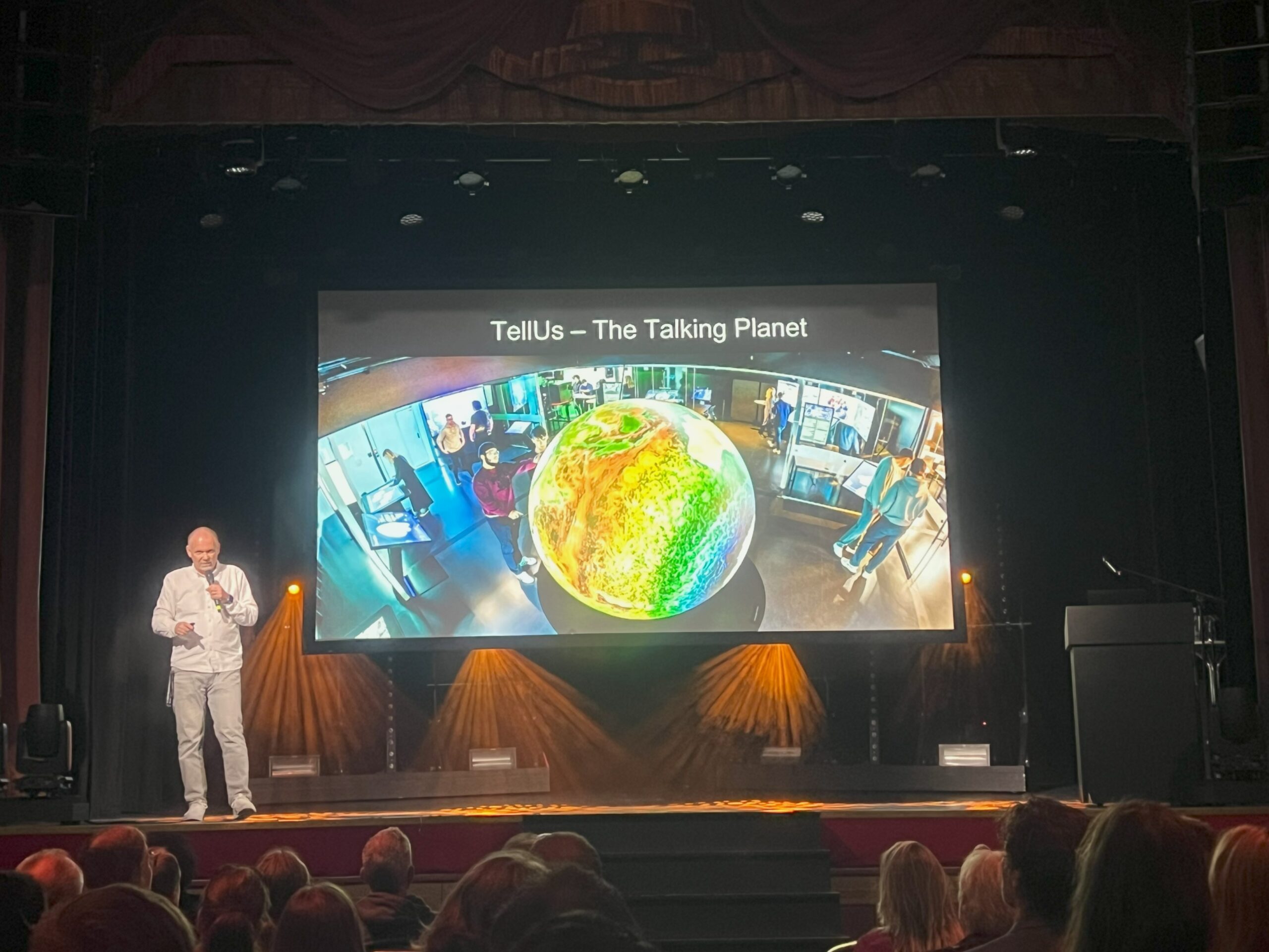
After a brief introduction and showcase of the sponsors, Anders Ynnerman, a Professor of Scientific Visualization from the Norrköping Visualization Centre at Linköpings University, gave the first presentation. Anders gave an introduction of the Norrköping Visualization Centre and discussed the Visual Sweden initiative, which seeks to promote development in visualization, image analysis and simulation.
Following this presentation, Marco Bernasocci, the Chair of QGIS.org, gave his QGIS.org update outlining important business and logistical information about QGIS. This included details about the organizational structure of QGIS, its financial standing, and funding sources of QGIS.org. Marco placed a significant emphasis on the transparency of QGIS funding and operation.
Following a coffee break (or Fika – as our Swedish hosts liked to remind us), Kurt Menke gave his QGIS Feature Frenzy, outlining QGIS updates in both the current long term release (3.40) and the latest release (3.42). Kurt took the time to compare these updates to some of the earlier versions of the software. Many of these updates focused on functions related to point clouds.
Following these presentations, the crowd split into separate lecture halls and classroom for a variety of technical sessions, workshops and community presentations.
Technical Presentations
There were a variety of technical presentations throughout the conference. Each presentation was scheduled for 30 minutes, with a small amount of time at the end of the presentation reserved for audience questions.
The first presentation I attended was with Jan Delheimer, a GIS and Software Engineer with Sweco. In his presentation My Database Can Do WHAT?, Jan outlined many of the advanced functions of PostgreSQL. This highly technical presentation discussed a variety of topics including complex data structures, lesser known extensions and how a PostgreSQL database can be integrated with AI and other APIs.
Jorge Gustavo Rocha, an Assistant Professor in the Computer Science Department at Minho University, discussed the technical elements of web mapping with databases in his presentation Turning PostGIS Databases into Web Maps. Over the last several years, Portugal’s mapping authority has updated their mapping standards to build on a new, open-source base. In his presentation, Jorge outlines how the transformation was completed using a PostGIS database.
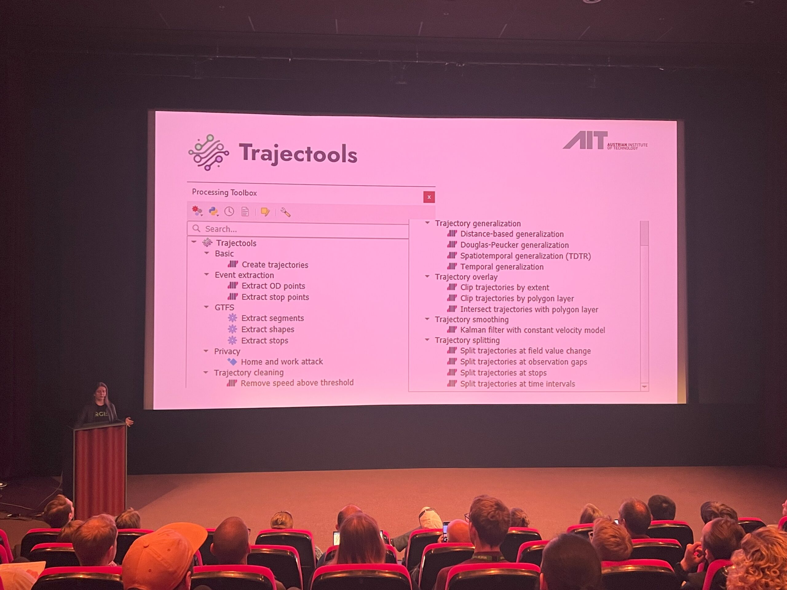
Anita Graser from the Austrian Institute of Technology discussed her Trajectool plugin during the presentation Trajectools: analyzing anything that moves. Built using the MovingPandas library, Trajectool allows users to work with real world movement data, which can be challenging to utilize. During her presentation, Anita discussed some real world examples where Trajectools can be useful, such as tracking animals or ocean vessels.
In his presentation QGIS based topographic data management in National Land Survey of Finland, Eero Hietanen discussed the National Land Survey of Finland and their four year process of integrating QGIS into their organization. While outlining the details of the integration, Eero discussed many of the successes and challenges associated with using QGIS in combination with PostGIS databases to meet the needs of the National Land Survey of Finland.
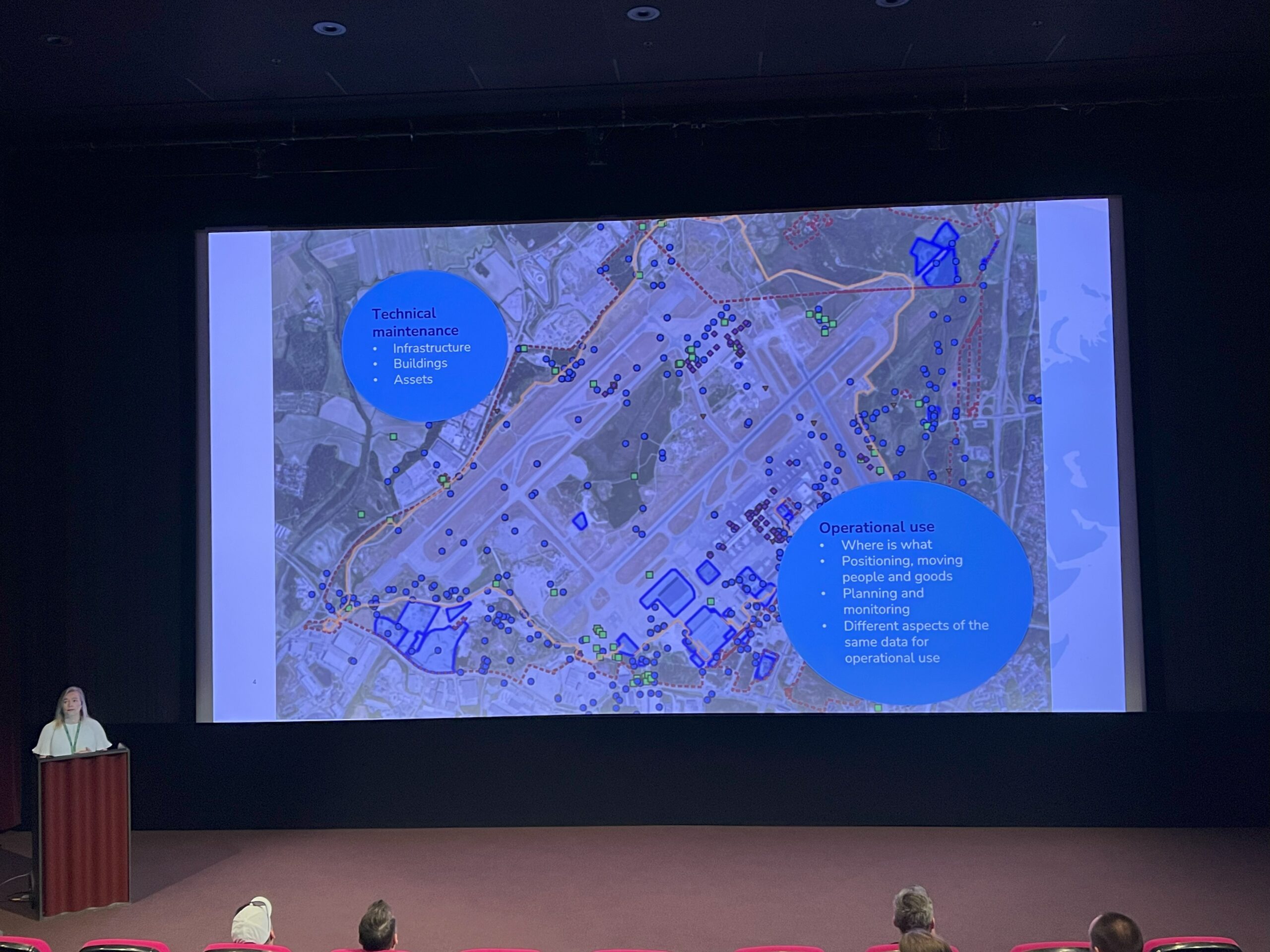
Representing Finavia, Finland’s public company in charge of the country’s airports, Pekka Sarkola and Eeva-Maria Viljakainen discussed the role of QGIS in the operation of Helsinki Airport. In their presentation Using QGIS to manage airport data, Pekka and Eeva-Maria discuss the complexities of managing spatial data within an airport, especially as GIS plays a vital role in both passenger and operational maps. There was an interesting audience question about sharing data, which highlighted the tension between sharing data for safety and restricting data for security.
Marios Kyriakou from the KIOS Research and Innovation Center of Excellence at the University of Cyprus discussed his team’s use of digital twins in his presentation QGIS as an Enabling Technology in Digital Twins for Critical Infrastructure. Utilizing the Cyprus Digital Twin, Marios and his team have built various tools for QGIS, such as the Digital Twin for Urban Water Contamination. This digital twin is helpful for first responders and other who may be affected by polluted water. The KIOS Open Science Committee, which Marios is a member, is a major contributor to the QGIS Cyprus community.
QGIS Workshops
Throughout the two days of the conference, there were a variety of hands-on workshops. Each workshop lasted for 90 minutes and focused on technical topics.
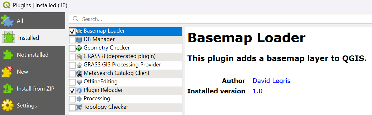
I attended the workshop Building Your First QGIS Pluggin. As a relative newcomer to GIS, I was excited to attend this workshop hosted by Ujaval Gandhi, the founder of the geospatial technologies learning platform Spatial Thoughts. This workshop was based on a Spatial Thoughts module and taught the basic process for building a QGIS plugin. Through step-by-step instructions supplemented with code snippets, each of use were able to quickly build our own Basemap Loader plugin. Ujaval also taught us about the technical components of a plugin and how to upload plugins to the QGIS plugin repository.
QGIS Community
Similar to the technical lectures, the lectures about the QGIS community were 30 minutes long, with a small amount of time for audience questions.
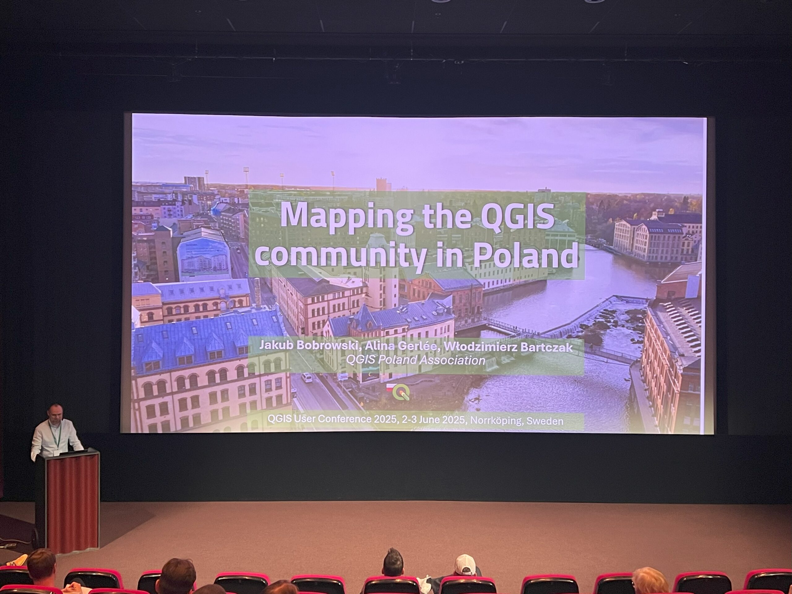
The first community presentation I attended was given by Jakub Bobrowski who discussed his team’s findings in Mapping the QGIS Community in Poland. Since 2002, the QGIS community in Poland has grown rapidly, but Jakub and his team found that little effort had gone into studying data such as demographic information, usage patterns, challenges and expectations of the QGIS community. In his presentation, Jakub outlined the findings of his team’s survey, including information about popular plugins, default GIS environments within universities and the frequency and reason for using QGIS. They found that the results of their survey roughly aligned with other international surveys on QGIS users.
Next, Raymond Nijssen from the Netherland’s QGIS User Group discussed the complexities of starting a national QGIS User Group in his presentation Celebrating Five Years of the Dutch QGIS User Group: A Success Story of Community and Collaboration. In his presentation, Raymond discussed the origins of the Netherland’s QGIS User Group, along with many of its logistical and financial concerns. During his presentation, Raymond outlined ways in which individuals can become involved with QGIS or a national QGIS User group. Raymond suggested that those of us without our own national group should consider starting our own.
Lastly, Lova Andriarimalala and Selma Vidimlić Husić discussed their work with QGIS documentation during the presentation Behind the Scene: QGIS Web Development & QGIS Documentation Writing in Action. In their discussion, Lova and Selma outlined information users can find in documentation, how documentation is created and the role that the QGIS community plays in creating documentation. There are many ways to become involved with documentation, whether it means translating existing documents into other languages or reporting errors found with the text.
A Warm Community
I was pleased by the warmth and passion of the QGIS community. Like so many open-source projects, QGIS is built and maintained on the back of a grassroots community of GIS users and developers who seek to create powerful and effective tools for the GIS community. During my time at the conference, I was able to learn and discuss highly technical information, better understand the role QGIS plays in large organizations and witness the power and camaraderie of national QGIS User Groups. Even if you are not a regular user of QGIS, it is hard to be unimpressed with the quality and brevity of the software and the community that builds it. For those who do use QGIS, it is worth noting that we currently do not have our own Canadian QGIS User Group. That sounds like a fun challenge.

Be the first to comment