
Digital Twins have many applications outside of the more well-known ones in the Internet of Things and Artificial Intelligence – including valuable applications for historic and archeological sites
A digital twin.
What is it exactly? Well, it is something in the physical world that has been recreated in the digital world. It can be a car engine for manufacturing, a city bridge for urban planning, or even a plant for interior design purposes. In this case however, it refers to the digital recreation of historic buildings and sites around the world.
As much as we would like to believe that historic sites and buildings will exist forever, the unfortunate reality is that simply they will not. Whether by time, nature, or humanity, these places that we cherish today will be gradually gone in the future. Sites such as the Giza pyramids, the Colosseum in Rome, and the Juukan Gorge in Australia have each experienced different forms of harm through different causes. The pyramids have been through ground water issues, urban growth, and the loss of its original limestone exterior for nearby buildings which came about by an earthquake. The Colosseum has seen a dozen or so different events happen to it such as earthquakes, lightning damage, and natural erosion over time, on top of losing parts of its travertine exterior for the same repurposing reason as the pyramids. Then there is the Juukan Gorge, a 46,000-year-old Australian Aborigines site that was recently demolished for the iron underneath. If we as a civilization do not take action to preserve the sites that our respective ancestors built as best we can, then they will one day turn to dust leaving us with no memory of them, or in recurring cases, they already have been. It is thus here where the digital twin emerges to preserve a digital copy of these places to counteract any and all effects by nature or by humans, that may and do transpire.
Digital Twins and Their Use in Heritage and Archaeology
There are groups all around the world who are creating their own digital twins of buildings, sites, and artifacts, and I am fortunate to be a part of this community. Through my 3D modelling work with Parks Canada since the beginning of this year and more so on my own since late 2017, I have been using multiple software programs to digitally build sites and buildings from scratch so that we as a civilization can see and appreciate these places no matter where or when we are. I have multiple goals for undertaking this, with the primary one being to get these digital twins out there to everyone in some shape or form. While this has yet to be finalized, leading ideas for publishing platforms consist of my own portfolio website, through Parks Canada, and also by way of ARCHES– the open-source platform for cultural heritage preservation. There are some issues in building these twins however, with leading examples being proper model texturing, scaling between buildings and digital landscapes, and determining the exact appearance of a site or building lost to time with little to no surviving documentation. All of these issues and more will need to be solved first of course before any official release of the twins are made. In the meantime, I will share with you here what I have been doing over the past three years and now through quarantine, and how I have been going about it.
3D Modelling Software
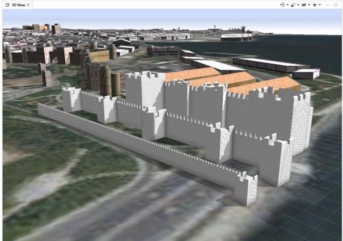
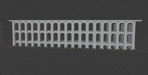
In one of my previous articles for GoGeomatics, I talked about the 3D recreated ancient cities that I have done and continue to work on through the use of Esri’s CityEngine city-building program. I have since added the 3D modelling programs Blender and Unreal Engine to my skillset which I continue to learn every time I open them. The other 3D landscaping and modelling program that is Unity is comparable to Unreal Engine and can also be used for this work, but I have simply become more familiar with UE and thus use it more for my work. There has been a steep but achievable learning curve in learning Blender, CityEngine, and Unreal Engine through the dedication and hard work that I have committed to what I can attain with these three. Through the use of these programs, I build the 3D models of a building or site in Blender, save them in the formats of predominantly Wavefront .obj or Collada .dae, then export/import them directly into the 3D environments of either CityEngine or Unreal Engine.
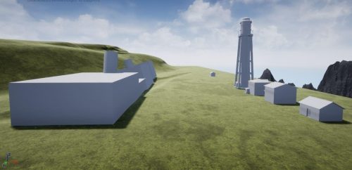
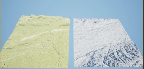
While CityEngine requires a license for full and long-term use, Blender is open-source and free, with Unreal Engine being free to use for experimenters, educational purposes, and non-profits. This is one of those other goals of mine in providing an inexpensive method for archaeologists, historians, and others for the ongoing study and investigation of the past that we do not know about in the present. Furthermore, I have also just discovered that I can import DEMs and DSMs directly into an Unreal Engine environment which allows for almost exact elevation landscapes to be worked with and in turn, saving time in building the digital landscape by hand (even though I still do and highly recommend people do too because it is an important modelling skill to have).
What I Have Been Working on During Quarantine
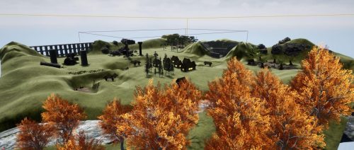
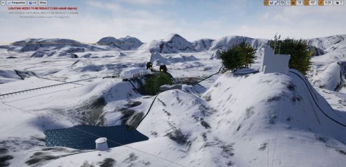
While I have mainly focused on heritage buildings and sites thus far, the scope of my work is gradually expanding towards using these programs to recreate archaeological sites and underwater shipwrecks. Doing so will provide another form of seeing what these sites are like in the present, as well as to provide opportunities to study the sites for further investigations as to what they looked like in the past and how they can be protected into the future while all in full 3D. For example, the image of Fig.3 below is a fictional archaeological site that I have built while in quarantine using my own models, and some 3D assets acquired through the Unreal Studio marketplace. This digital site features dig pits with exposed soil layers, excavated artifact staging areas, partially excavated artifacts, living quarters, several ruins, and a yet unexcavated surprise or two.
Where Do We Go from Here?
The truth of the matter is that sadly, these sites will not last forever and so, from structures to buildings to sites to whole cities, it is imperative that we continue to meet the challenges of preserving a record of the past in the present for the future. From reading more heritage and archaeology-related articles, to volunteering with heritage and archaeological groups, to taking part in heritage preservation webinars and talks, touring virtual museum exhibits, and simply giving a voice of support for heritage and archaeology work across different media, you too can become involved with helping preserve a record of our collective past no matter where you reside. While difficulties remain, they are worth overcoming which falls on all of us so I ask you to join me and the 3D heritage modelling community to do what you can so that even if all that remains of a place is a digital twin, the memory and 3D visualization of it will nonetheless remain with us as a civilization.
References
https://cims.carleton.ca/#/projects/ParliamentHillTopography
https://www.cyark.org/projects/
http://www.openculture.com/2017/07/the-first-3d-scan-of-the-rosetta-stone-now-online.html
https://archpaper.com/2020/03/google-arts-culture-over-500-virtual-museums/#gallery-0-slide-2
Resources
https://www.archesproject.org/
https://www.unrealengine.com/en-US/
https://www.esri.com/en-us/arcgis/products/arcgis-cityengine/overview


Be the first to comment