Community
Ground Truthing
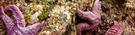
In the world of Remote Sensing, one of the key concepts is ground truthing. This has both a positional component, as well as a field verification of the land cover. These complementary activities are important […]
In the world of Remote Sensing, one of the key concepts is ground truthing. This has both a positional component, as well as a field verification of the land cover. These complementary activities are important […]
In my previous blog “Storytelling: Haida Gwaii,” I referenced the Geomatics Association of Nova Scotia’s (GANS) mentoring program between myself and Melissa Ristow, COGS graduate 2015. Together, our idea was to explore the Story Mapping […]
Haida Gwaii is a rich source for stories. There are many perspectives and many different formats. In the Haida culture there is the oral tradition. The first comprehensive versions of these stories were transcribed and […]
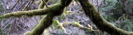
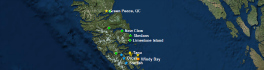
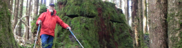
Over the Easter break, I was walking along the North shore of Graham Island towards Tow Hill (pictured below). At the foot of Tow Hill in Haida, Taaw Tldaaw – literally Grease Mountain – there […]
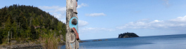
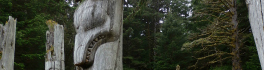
Canada, with its endless coastline, has thousands of islands. Besides the physical islands with tangible, defined boundaries, there are also cultural islands with intangible, virtual boundaries. As N.J. Turner describes in Plants of Haida Gwaii, […]
One of the joys of leaving your residence on one coast (Annapolis Valley, Nova Scotia) and moving to a new temporary home on the west coast (Haida Gwaii) is the opportunity to ‘unclutter’ the mind. […]
Are there too many GIS post-diploma programs and University GIS certifications in Canada? In the late 1980s, the prevailing notion was that we had three GIS post-diploma programs in Canada, at BCIT, SSFC and COGS. […]

In England, as a teenager, we used to conduct ‘table top’ car rallies, using the 1 inch to 1 mile OS maps (1:63,360). The clues had to be restricted to the symbols available at that […]