Technology
International Geospatial Briefing Nov 22: 1. Two million square km of the seafloor mapped. 2. Importance of marine geospatial data. 3. Using smartphones to map road potholes. 4. Into the metaverse. 5. The Geography of Mysteries. 6. Mapping our human footprint.
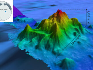
NOAA Ocean Exploration Meets Major Mapping Milestone on NOAA Ship Okeanos Explorer The National Oceanic and Atmospheric Administration (NOAA) has reached a major mapping milestone with two million square kilometers of the seafloor mapped. To achieve […]