Jon Murphy
Jonathan Murphy is the CEO, President, and Founder of GoGeomatics Canada. He is also the founder and chair of GeoIgnite, Canada's national geospatial leadership conference, and Canada's National Geomatics expo.
Jon has created Canada’s largest professional geospatial network, aiming to strengthen and empower our geospatial ecosystem.
A community builder and connector, he holds a bachelor's degree in Archaeology from the University of Calgary and advanced diplomas in GIS and applied geomatics research from COGS.
Jon is a Fellow of the Royal Canadian Geographical Society. In 2020, he joined the ISO/TC 211 Geographic information/Geomatics Technical Committee responsible for the ISO geographic information series of standards. In 2023, Jon joined the board of directors of buildingSMART Canada.
Articles by Jon Murphy
Karl Kliparchuk talks top GIS Education at BCIT in Vancouver, BC, Canada
GoGeomatics kicks off our series of interview with geospatial program across the country on the West Coast of Canada. We…
Tarin’s Kim Koons discusses future of the geospatial data business in Canada
A GIS is not much use without the data. GoGeomatics turns our attention to Tarin Resource Services in order to…
The Best GIS Education Programs in the World are in Canada
In honour of the 5th annual Back to School GoGeomatics Socials, we are going back to our roots. Some of…
Sparkgeo Interview with Will Cadell, one of Canada’s most Innovative Geospatial Entrepreneurs
GoGeomatics: Hi Will. Thanks for taking the time to talk to the GoGeomatics community. You’re a successful geospatial entrepreneur with a…
Meeting the GIS & Geomatics Scientists, Specialists and Managers at the CCMEO
The Canada Centre for Mapping and Earth Observation (CCMEO) is the Government of Canada’s centre of excellence for geomatics, mapping…
Take our Leadership Survey: In 2018 Canada dropped from 4th to 7th on Global Geospatial Readiness Index
Quite of few Canadian geomatics specialists have been scratching our heads since news broke that Canada dropped 3 spots on…
Take the Survey: Dutch students study Canadian Geospatial Data Infrastructure (CGDI)
Last week I saw a tweet that caught my attention from Europe. Four students taking the Geographical information management and…
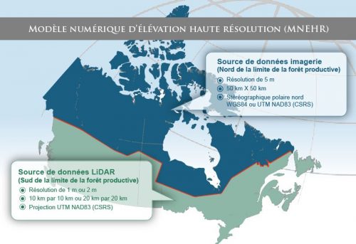
La révolution des données d’élévation du CCCOT a commencé: nouveau MNÉ du Canada
Ohé le Canada: il est de nouveau temps de s’exciter sur les données d’élévation! Pendant des années, si ce n’est…
CCMEO’s Elevation Data Revolution has Begun: Canada’s New DEM
Cet article est aussi disponible en français: https://gogeomatics.ca/la-revolution-des-donnees-delevation-du-cccot-a-commence-nouveau-mne-du-canada/ Hey Canada: It’s time to get excited about elevation data again! For…
Les 5 = ensembles de données vectorielles SIG canadiens les plus populaires
Nous parlons ici de données vectorielles SIG. Il s’agit d’une sous-catégorie des données géospatiales que le Centre canadien de cartographie…
Find a GIS Job: Ottawa Geospatial Career Seminar February 24th, 2018
Finding a job in geospatial technology can be difficult. That’s why GoGeomatics Canada is bringing back our popular Career Seminar…
The Top 5 Most Popular Canadian GIS Vector Data Sets
We’re talking GIS vector data, it’s a subset of the geospatial data that NRCan’s Canada Centre for Mapping and Earth…


