
The Quiet Infrastructure That Sovereign Nations Cannot Afford to Ignore
It is easy to assume that location is settled.
Not because it is simple, but because it is reliable. Coordinates align. Elevations are trusted. Datasets collected years apart still come together cleanly. Most users expect this to just work, assuming the systems behind it have already been figured out and are being maintained.
That assumption is worth questioning.
The Layer Beneath the Map
Every geospatial decision Canada makes, from pipeline routing to flood risk modelling, from Arctic sovereignty assertions to municipal infrastructure planning, rests on a reference layer that most decision makers rarely pay attention to.
That layer is geodesy.
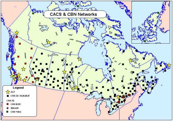
The Canadian Geodetic Survey, a branch of Natural Resources Canada, defines and maintains the Canadian Spatial Reference System, the CSRS, which establishes the authoritative reference for latitude, longitude, height, and gravity across the country. The current realization, NAD83(CSRS) v8, incorporates GNSS observations, reprocessed historical data, and adjustments for ongoing surface motion including glacial isostatic adjustment. A national network of continuously operating GNSS reference stations, the CACS, anchors Canada’s frame to the International Terrestrial Reference Frame and monitors how the Canadian landmass moves over time.
This is not background infrastructure. It is the reason it works. It is why geospatial data from different sources, collected at different times, can still be trusted to align
And yet, unlike Canada’s 5G networks, its cloud data policy, or its strategic minerals framework, geodetic infrastructure rarely appears in a policy conversation.
Sovereignty Is a Layer Problem
Positioning today is the product of multiple layers working together. Each layer depends on the one beneath it. And each layer introduces a question about who controls it.
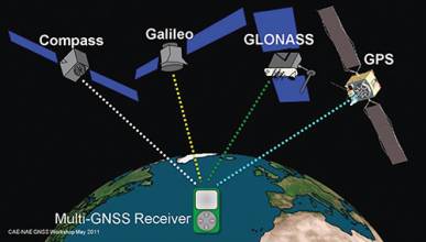
At the top, satellite constellations, GPS operated by the United States, GLONASS by Russia, Galileo by the European Union, BeiDou by China – provide signals that Canada, like every other country, receives but does not control. Below that, correction services and processing platforms translate raw signals into usable data. Many of these are developed and operated outside the jurisdictions where they are applied.
At the base of the stack sits geodesy: the national reference frames, vertical datums, gravity models, and ground control networks that define what a position actually means within Canadian territory.
Canada maintains meaningful sovereignty at the base. The CSRS is a genuine national asset. But the layers above it introduce dependencies that compound with each passing year, and which grow harder to see precisely because everything continues to work.
The problem, as practitioners at the 2025 PNT Summit described it, is not signal failure. It is a growing dependency, one that runs through aviation, rail signalling, port logistics, grid operations, and public safety dispatch. As one speaker put it, “the nation is not defending signals; it is defending a dependency.
Canada is not immune to that dependency. We just have not had to confront it yet.
The Global Signal Is No Longer Reliable Background Noise
For decades, the signals underpinning positioning were treated as infrastructure so stable they were essentially invisible. That assumption is now being stress-tested in ways that matter directly to how Canada should think about its own systems.
According to IATA data, GPS signal loss events increased by 220 percent between 2021 and 2024. By 2025, approximately 1,000 daily incidents of GPS interference, either spoofing or jamming, were occurring globally. These are not confined to conflict zones. In January 2026, 13 coastal European nations and Iceland collectively highlighted “growing GNSS interference” and called for compliance with international regulations designed to ensure the safety of maritime vessels.
The implications for civil infrastructure are concrete. Whether interference is accidental or deliberate, the operational effect is the same: confidence drops, and the costs cascade into scheduling, safety buffers, and throughput.
Peer nations have responded with investment. Australia committed AUD $224.9 million to its Positioning Australia program, building a national network of over 700 continuously operating reference stations to deliver centimetre-level accuracy across the country. The United Kingdom announced $202 million to protect essential national positioning signals, including $92 million to begin building a national eLoran network, a backup system whose signals are millions of times stronger at the receiver than GPS and far harder to jam.
These are not reactions to crisis. They are investments made while systems are working, precisely because waiting for a failure to prompt action is the more expensive path.
Canada’s geodetic infrastructure is functioning well. The question is whether the investment profile reflects that functioning or merely depends on it.
The Vertical Problem That Isn’t Hypothetical
The clearest illustration of what under-investment looks like in practice is Canada’s height system.
Canada adopted the Canadian Geodetic Vertical Datum of 2013 – CGVD2013 – as its federally authoritative gravity-based height system a decade ago. It is more accurate than what it replaced, better suited to the geoid-based approaches now standard internationally, and essential for the kind of reliable elevation data that flood modelling, coastal management, and infrastructure design require.
But the legacy CGVD28 – a levelling-based system from 1928 – remains in active use across several provinces. Differences between the two systems run from approximately 10 centimetres to 1 metre, requiring many agencies to provide reference coordinates in both systems simultaneously.
A 1-metre elevation discrepancy in a flood boundary model does not announce itself as a datum inconsistency. It shows up as a mis-drawn risk zone, a poorly sited piece of infrastructure, or a community that did not prepare for water that arrived at a level the model said it wouldn’t.
This is the nature of geodetic risk. It does not fail loudly. It accumulates quietly in the decisions that were made on faulty assumptions.
A Once-in-a-Generation Window
The modernization of Canada’s spatial reference system – the adoption of NATRF2022 represents a shift that occurs roughly every 50 to 100 years. It is being developed in coordination with the United States National Geodetic Survey, and provincial adoption is targeted for 2030.
The transition touches treaty maps, land survey registries, data acquisition contracts, and regulatory geodetic datums across every jurisdiction in the country. Done well, it produces a unified national reference system – a foundation that Canada’s geospatial infrastructure can rely on for the next half century. Under-resourced, it produces a prolonged period of fragmentation in which federal and provincial systems operate on different assumptions, and the costs appear not as failed systems but as accumulating inefficiency and error.
The 2025 PNT Summit framed the broader challenge clearly: “For decades, GPS was both capability and assumption. The comfort of ubiquity displaced the discipline of resilience.” The same could be said of geodetic infrastructure. Its reliability has made it easy to take for granted.
The Policy Frame Canada Already Has – Just Not Applied Here
Canada has demonstrated, in other domains, that it understands what critical infrastructure sovereignty requires.
The ban on Huawei and ZTE from Canada’s 5G networks established the principle that foreign-built systems carrying strategic national communications are a national security concern, regardless of their current reliability. The mandate for domestic cloud hosting of sensitive government data established that where data lives, and who controls the systems that hold it – is a policy question, not only a technical one.
The US National Geospatial-Intelligence Agency, in Congressional testimony in 2025, described its responsibility for “guaranteeing assured precision and accuracy of GPS and maintaining the World Geodetic System 1984 reference frame, which is the backbone for all geolocation” – framing geodetic infrastructure explicitly as a national security asset.
Canada does not need to replicate the American approach. But it does need to recognize that its peers – in Washington, London, and Canberra, have arrived at the same conclusion: the systems that define where things are, in a country’s own territory, are not technical background. They are strategic infrastructure.
NRCan’s consultation on a Canadian Geospatial Data Strategy, which closed in March 2025, is expected to inform a national strategy in the near term. That strategy will be an important document. Whether it names geodetic infrastructure as critical national infrastructure – with the investment and policy attention that designation carries, will say a great deal about whether Canada is serious about the foundation its geospatial future is built on.
The Argument for Acting Now
“The time to repair the roof is when the sun is shining,” Kennedy said. The roof here is not cracked. The systems are working. The CSRS is maintained. The Canadian Geodetic Survey is doing its work.
The question is not whether Canada’s geodetic infrastructure is functioning today. It is whether the investment, policy attention, and institutional capacity are in place to keep it functioning, and to ensure that Canada shapes these systems rather than simply inheriting whatever the broader international framework produces.
Once reference definitions are widely adopted, they become extraordinarily difficult to revisit. Everything else has already aligned to them.
The window to act is open. It will not remain open indefinitely.
Canada needs to decide whether it will define its own coordinates or accept definitions set elsewhere and call that sovereignty.
Sources:
Inside GNSS, IATA, Dark Reading, GPS World, Business Standard, Government of Canada Publications, GoGeomatics, National Geospatial-Intelligence Agency, Natural Resources Canada


Be the first to comment