“You’ll never walk alone”
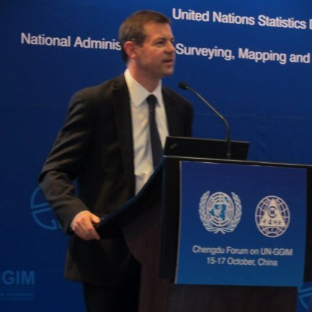
I attended the seventh session of the UN Committee of Experts on Global Geospatial Information Management (UN-GGIM7) last month. It is my sixth year of involvement with UN-GGIM and with almost 400 delegates from circa 90 countries and international organizations active in the field of geospatial information management it was an amazing venue to learn and share ideas relating to geospatial policy and good practice. 
Apart from the learning, it was a good reminder that we need strong leadership to guide national governments on global geospatial information management. Notably, there have been efforts by organisations to introduce government policy and legislation that don’t necessarily encompass the geospatial intricacies or complexities or licensing or numerous other aspects that organisations, such as the Group on Earth Observations (GEO) and UN-GGIM have been working on for many years as organisations and spanning entire careers for individuals. This is particularly true as we see more technological advances around Unmanned Aerial Vehicles (UAVs), machine to machine (M2M) communications, Internet of Things (IoT) and even developments and the broader reach of mobile Internet.
After numerous years working with the Open Geospatial Consortium (OGC), UN-GGIM and now at GEO, what I know to be true is that countries don’t have to go it alone when it comes to geospatial policy and planning. Yes, countries obviously have to develop their own administrative (including financial) and legal processes, as well as human and technological systems, however the challenges we are facing today are common across the globe. This is why the GEO engagement priorities around the UN 2030 Agenda for Sustainable Development, Paris Agreement for Climate Change and the Sendai Framework for Disaster Risk Reduction all make sense across the global geospatial arena.
During the course of the week the UN-GGIM Committee considered a number of substantive agenda items, including: the contribution of regional committees and UN-GGIM networks to the global geospatial information agenda; strengthening geospatial information management; a global geodetic reference frame; land administration and management; national institutional arrangements; global fundamental geospatial data themes; geospatial information and services for disasters; national geospatial data and information systems; marine geospatial information; legal and policy frameworks, and implementing the 2030 Agenda through geospatial information and its integration with statistics. *source ggim.un.org
This rich source of information and activity is open to all national governments that commit and invest the time, energy and money to support the inclusion of geospatial data, software and services in global UN Member State policy to drive analysis and decision making.
I played two roles at UN-GGIM. Firstly as a panelist on the ‘Where’s the data?’ Panel as an invited speaker regarding Earth observation data and information to support the SDG process. Secondly in the role as Observer from GEO during the formal UN-GGIM process.
The formal Committee session was accompanied by a programme of side events including a Forum on the 2030 Agenda for Sustainable Development “Where is the Data?” Attended by more than 200 participants, the Forum explored how we will measure, monitor and report progress on the 17 Sustainable Development Goals (SDGs) and their associated targets and indicators with geospatial information. On the panel I joined a number of people already working closely with geospatial data and the SDG process, such as Bob Chen from CIESIN at Columbia University and Aditya Agrawal from the Global Partnership for Sustainable Development Data (GPSDD); both organisations are collaborating with the GEO community around capacity development and raising awareness of the usefulness and value of EO for delivering the SDGs.

The Canadian Government representatives at UN-GGIM were from Natural Resources Canada (NRCan) and Statistics Canada. Prashant Shukle, Director General of the Canada Centre for Mapping and Earth Observation, NRCan made a simple, but one of the most significant interventions during the UN-GGIM meeting. This was to remember the importance and the role of open data. This resonated with me because of the major progress that has been made with the Open Government Partnership over recent years to develop such thinking at senior government levels, as well as the role of GEO to promote broad open data policies. Canada also has a great success story in this arena with RADARSAT – http://www.asc-csa.gc.ca/eng/satellites/radarsat/Default.asp from the Canadian Space Agency (CSA), a GEO Member, and their public private partnership with MDA, NASA and others.
It’s important to stress here that despite the drive for opening up public data, particularly Earth observations, the GEO community also recognises and supports the role of the private sector and isn’t trying to push commercial vendors to provide their data or services for free. In fact, the private sector offers essential knowledge, expertise, resources and skills for the future development of public policy making. In both GEO and UN-GGIM, through the Private Sector Network there are key roles to be played around developing value added products and services, data access, innovation, capacity development and service delivery.
During the UN-GGIM Plenary meeting, I also made several interventions relating to the importance of integrating statistics and socioeconomic data with Earth observations to support decision making relating to SDGs. Also explicitly thanking the countries supporting the EO4SDGs initiative and inviting other UN Member States to contribute to or observe the activities. There was another intervention to also highlight the inclusion of EO language in the Sendai Framework Data Readiness Review and further discussions are planned in Geneva to review the links between the Sendai Framework, the SDGs and the value added by Earth observations. All of these activities aim to bring decision makers together in governments across the world, namely to join up government thinking and facilitate analysis and decision making through open Earth observation data and information; also supported by private sector engagement.
Among the significant outcomes of the session were the establishment of two new Working Groups on Legal and Policy Frameworks, and Marine Geospatial Information; the adoption of a Strategic Framework on Geospatial Information and Services for Disasters; the endorsement of an overarching framework for national institutional arrangements on geospatial information; and a collaborative agreement with the World Bank to implement a new initiative to assist low-income countries to develop their national geospatial information systems. The Committee also welcomed the convening of the fifth High Level Forum on United Nations Global Geospatial Information Management, hosted by INEGI of Mexico in Mexico City in November 2017, with an overarching theme “Implementing the Sustainable Development Goals: The Role of Geospatial Technology and Innovation”.
These actions include, developing frameworks, guides, standards and methodological development along with capacity development for geospatial information management; with a particular emphasis on the 2030 Agenda for Sustainable Development. For me, the outstanding topic, which will always be critical, is the human interaction or interoperability, if you prefer that word. Technology is always developing, adapting to our requirements and improving, but without better cooperation, collaboration and coordination having great technology is almost meaningless.
Work is ongoing with GEO and UN-GGIM regarding strategic engagement and raising the profile of global geospatial information management at the national level. Particularly since there are numerous touch points across the Member States, as well as thematic and regional activities. Contributions are welcome from around the world. In particular, national governments are welcome to attend the GEO Plenary being held in Washington DC from 23-27 October 2017.


Be the first to comment