RCGS (Royal Canadian Geographical Society) releases a new map in solidarity with Ukraine.

The Royal Canadian Geographical Society produced this map to show the distribution of people from Ukraine across provinces of Canada. Each colour picked by the cartographer indicates statistical division across Canada. Read more here
YVR launches its digital twin, making people and the community the center of its digital transformation.

North America’s best airport YVR (Vancouver) is using its data to come up with a solution to mitigate various challenges and help the future growth of the region.
Image source: https://www.richmond-news.com/local-news/yvr-launches-digital-twin-to-simulate-real-time-airport-experience-5223959
Digital twin is a digital tool that allows training, optimization, future planning, simulation, testing, and more by visualizing data. Through the integration of sensors, historical and real-time data into the platform, the digital twin can present key information through 2D or 3D visualization, enabling data-driven decision making and collaboration which has never been available before. Read more here
Kraken’s Robotics as a Service (RaaS) Contract with Royal Canadian Navy Deemed ‘Success’.

Canadian marine robotics company Kraken Robotics Inc. has successfully completed a Robotics as a Service (RaaS) contract with the Royal Canadian Navy, for the testing of Kraken’s ultra-high-resolution survey equipment. As a result, RCN has access to cutting edge technology and high-resolution images for the identification of objects and change detection under the sea.
Image: Car Wrecks Surveyed with Legacy Side-Scan (top) vs Kraken’s LW-SAS (bottom) – ©Kraken Robotics: Marine Technology news
The Royal Canadian Navy has approved to develop and maintain an advanced sonar imaging and data storage capability for all three coasts, and to install this capability in national and international areas of interest. Read more here
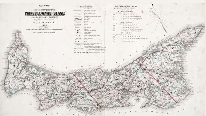
A look at the 19th-century atlas that ‘defined’ P.E.I.

James Hubbard Meacham was a savvy Canadian entrepreneur who turned into a cartographer along with his partner Clement Allen set up a publishing company to publish a full atlas of Prince Edward Island that gives spectators a sneak peek into how the island looks 150 years ago. This map was published in the year 1880. Read more here


Be the first to comment