
- AI and thermal drones are helping find the lost in B.C.’s mountains
- Split city: Some B.C. voters don’t feel represented as urban centres carved into sprawling, rural ridings
- Canadian satellite launches could set record in 2025
- Hot wheels: Researcher pedals through Mississauga to map air temperature differences
- Alberta finalizing flood maps faster than ever before
- EarthDaily Analytics to Launch Its First Satellite This Summer
AI and thermal drones are helping find the lost in B.C.’s mountains
North Shore Rescue, located in Vancouver, is using AI and thermal cameras on drones to help find lost people in B.C.’s mountains. The hope is that adding drones with specific cameras and machine learning will speed up the process, bringing more people to safety. Drones offer a unique range that other means of search and rescue, like all-terrain vehicles, snowmobiles, or helicopters, do not provide. Drones have a great range to detect people easily, as well as being a safer first option to scout out hard-to-reach areas. The accessibility of drones, machine learning, and lightweight high-tech cameras showcases how geospatial knowledge can help in many sectors, such as search and rescue. The article goes into more procedural details here
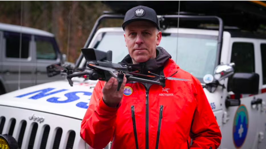
Grant Baldwin, a drone operator for North Shore Rescue in Vancouver, says the addition of drones equipped with thermal imaging and artificial intelligence software could be a game-changer in the group’s searchers for lost or injured people in the mountains. (Source: Dillon Hodgin/CBC)
Split city: Some B.C. voters don’t feel represented as urban centres carved into sprawling, rural ridings
With the new election happening, some residents may have checked how their electoral ridings have changed. Prince George, B.C. has previously been grouped in the Cariboo-Prince George region, with the next closest major community being 100 Mile house, which is roughly over 300km away from each other. But now that same riding has shifted to Prince George-Peace River-Northern Rockies, which is now being paired with places such as Dawson Creek, Fort St. John and Fort Nelson, which are all substantially further away from Prince George. It seems that Prince George as a community keeps having their riding shifted, which takes away from the community connection, which is important for representation for voters to align with. This helps showcase the power geospatial mapping has when deciding new boundaries and can have social shifts on even voting if not taken into account properly. Read in more delta how this has affected a particular community member here
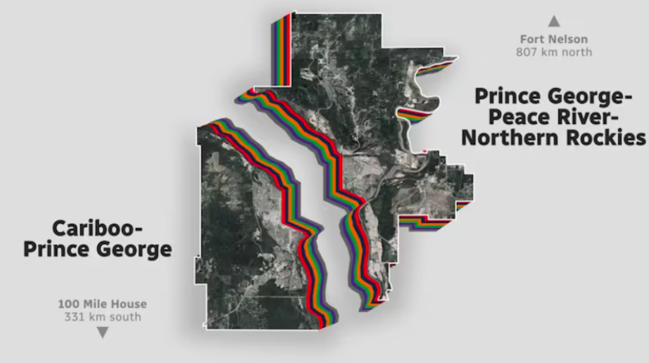
The City of Prince George, the largest municipality in northern B.C., is divided into two separate federal ridings — ridings that sprawl hundreds of kilometres by road to smaller, outlying communities, which some voters say fails to adequately represent the region. (Source: CBC News)
Canadian satellite launches could set record in 2025
33 Canadian satellites are tentatively ready to be launched over the rest of 2025, with three already launched as of writing this digest. This sets the bar for launching a new record number of satellites for Canada, breaking the previous record of 24 in 2023 with 36 this year. The first three satellites launched were under Defence Research and Development Canada (DRDC) to “demonstration mission to support Canada’s ability to exercise sovereignty in the Arctic and provide enhanced situational awareness for safety and security applications.” Read more about the launch road map for future satellites here
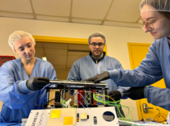
Galaxia staff working on MÖBIUS-1 satellite. (Source: Galaxia Mission Systems)
Hot wheels: Researcher pedals through Mississauga to map air temperature differences
University of Toronto Mississauga has conducted a recent study that offers a more accurate procedure to map air temperatures in urban environments. This can help cities better document heat patterns and effects. PhD student and Geographic Information Systems (GIS) researcher Scarlett Rakowska has collected her data by biking through the streets of Mississauga, ON. The goal is to test if mobile, ground-level monitoring can capture the slight differences that traditional weather stations may miss. The results showed that there are small but important variations in heat levels across the city. Read in more detail on the study here
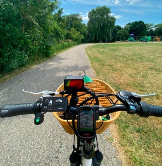
Rakowska outfitted her bike with a temperature sensor, GPS and camera to collect hyper-local data across Mississauga. (Source: photo courtesy of Scarlett Rakowska)
Alberta finalizing flood maps faster than ever before
The Government of Alberta has finalized more flood maps in the past five years than in the previous 35 combined. With some severe flooding that has occurred across Alberta in the last decade, ensuring that maps are up to date is crucial. This allows first responders and local emergency response teams to have the right information, so that in the case of an event, situations can be handled quickly. The province is also seeking feedback on four flood map studies nearing completion, including Hinton, Vegreville, Stettler, Red Deer County and Markerville. Read more details on the flood mapping plan here
EarthDaily Analytics to Launch Its First Satellite This Summer
EarthDaily Analytics has announced their 10-satellite, a satellite with an integrated payload with one of Loft Orbital’s Longbow satellite buses, which has completed spacecraft-level environmental testing. This is not only a big milestone for EarthDaily being their first constellation satellite to launch, but also as a Canadian company showcasing their success in satellite observation. Once deployed, EarthDaily Constellation will provide high-quality Earth observation data. Learn more about this achievement and the consultation process here

EarthDaily Constellation Unlocks the Power of Broad-Area Change Detection to Deliver Unmatched Value Across High-Impact Industries


Be the first to comment