- The wildfire-fighting drones of the future.
- Restoring salmon habitat: An interactive map
- The maps selected for the 2024 Esri Canada Map Calendar
- Autonomous plant stand counting with Croptomistic
- Visualizing climate change in the Canadian Arctic
The wildfire-fighting drones of the future
The story: Researchers in Moncton, New Brunswick, are pioneering artificial intelligence (AI) for wildfire management. The AI system, still in development, aims to enhance early detection and response to wildfires. By analyzing satellite imagery and climate data, the technology can predict fire risks and optimize firefighting strategies. To read more click here.
Why it is newsworthy: In their work at Perception, Robotics, and Intelligent Machines Laboratory, these researchers have combined geospatial data and AI in what would be a significant advancement for wildfire detection and prevention. This represents an incredible example of how GIS and AI will change the world in unforeseen ways. By contributing to proactive wildfire mitigation strategies, this innovation holds the potential to significantly improve wildfire prevention and management, showcasing the transformative impact of pairing geospatial intelligence with AI to address environmental challenges like wildfires.
Restoring salmon habitat: An interactive map
The story: Raincoast Conservation Foundation’s latest initiative focuses on enhancing fish passage and restoring habitat in the Lower Fraser River Estuary. The project aims to address barriers impeding fish migration, contributing to the recovery of diverse fish species in the region. By prioritizing connectivity in aquatic ecosystems, Raincoast aims to bolster biodiversity and ecosystem health. A big part of the project is the high-quality interactive map created to visualize where this incredible work is happening. To explore this great map, click here.

Why it is newsworthy: This story highlights the intersection of conservation efforts and geospatial analysis. While mapping and analyzing the estuarine landscape play a crucial role in identifying key areas for habitat restoration and effective fish passage, this story and the interactive map highlight the important role GIS can play in science communication and storytelling.
The maps selected for the 2024 Esri Canada Map Calendar
The story: Esri Canada has unveiled the maps chosen for the 2024 Esri Canada Map Calendar. This collection showcases diverse and visually compelling maps created by Canadian GIS professionals. The selected maps demonstrate the versatility of geospatial data in addressing various themes, offering insights into Canadian landscapes, ecosystems, and cultural diversity. The calendar serves as a testament to the creative and impactful applications of GIS technology in capturing the nation’s geographic richness. To check out the other winning maps, click here.

Why it is newsworthy: This announcement highlights the annual celebration of exceptional map-making achievements. The chosen maps exemplify the power of GIS tools in visual storytelling and data representation. GIS professionals can draw inspiration from these selections, gaining insights into effective map design and storytelling techniques. Additionally, recognizing these maps provides a platform for sharing best practices and fostering a sense of community among GIS practitioners nationwide.
Autonomous plant stand counting with Croptomistic
The story: Croptimistic introduced a ground-breaking new tool for farmers, SWAT CAM, a fully autonomous plant stand counting technology. This innovation allows for precise and efficient plant counting across large agricultural areas, enhancing crop monitoring capabilities. The autonomous system utilizes drone-captured footage and advanced algorithms to provide accurate plant stand data, optimizing agricultural practices for improved yield management and resource utilization. To learn more about this incredible tech, click here.
Why it is newsworthy: Croptimistic’s autonomous plant counting technology represents a leap in precision agriculture. This integration of geospatial technology offers valuable data for optimizing farm operations. This advancement signals a shift toward more data-driven and efficient agricultural practices, showcasing the transformative impact of GIS in the agriculture sector.
Visualizing climate change in the Canadian Arctic
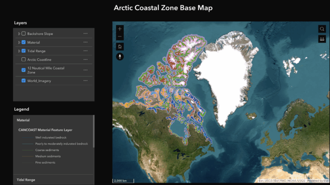
The story: Esri Canada explores the impact of climate change in the Canadian Arctic through geospatial technology. The initiative visualizes environmental changes, such as sea ice decline and permafrost thawing, using GIS platforms. By creating interactive maps and visualizations, the project aims to raise awareness about the profound shifts in the Arctic landscape, warming at double the rate of the rest of the world. Of particular interest are the CanCoast datasets available on the project, a part of NRCan’s Climate Change Geoscience Program. To explore this incredible resource, click here.
Why it is newsworthy: This project exemplifies the pivotal role of geospatial technology in climate change studies. The interactive visualizations enable a comprehensive understanding of environmental changes, aiding scientists, policymakers, and the public. Collaborations in leveraging geospatial tools can contribute to a more informed approach to addressing the challenges posed by climate change, especially in environmentally sensitive areas like the Arctic.


Be the first to comment