- Making investments in energy-modelling tools to bolster efforts in reducing emissions
- “Open Urban Forests” The First National View of Urban Forestry Geospatial Data in Canada
- Hazardous fuel map to predict wildfires
- Canadian Wetland Inventory
- Achieving NG9-1-1 compliance; City of Edmonton journey
- National Indigenous History Month with ArcGIS
- What are some fun ideas to wrap up the school year with GIS?
Making investments in energy-modelling tools to bolster efforts in reducing emissions
To reduce emissions and combating climate change while considering existing and emerging energy technologies, the Canadian government is investing in 3 energy-modelling projects.
The initiatives include the development of a net-zero energy-modelling platform and data visualization dashboard, the integration of energy models to provide publicly available modelling data on Canada’s net-zero energy future, and the update of the Energy Policy Simulator to reflect potential technology pathways. Read more here.
“Open Urban Forests” The First National View of Urban Forestry Geospatial Data in Canada
The Canadian Institute of Forestry (CIF) has informed the Burlington Mayor’s Office about their utilization of the city’s tree inventory data for their project called “Open Urban Forests.”
The project’s objectives include reviewing urban forestry data accessibility, creating a National Advisory Committee, and developing best management practices for data collection and standardization. Burlington’s open accessible data will be included in the project’s interactive learning hub, benefiting decision-making and climate change monitoring. Read more here.

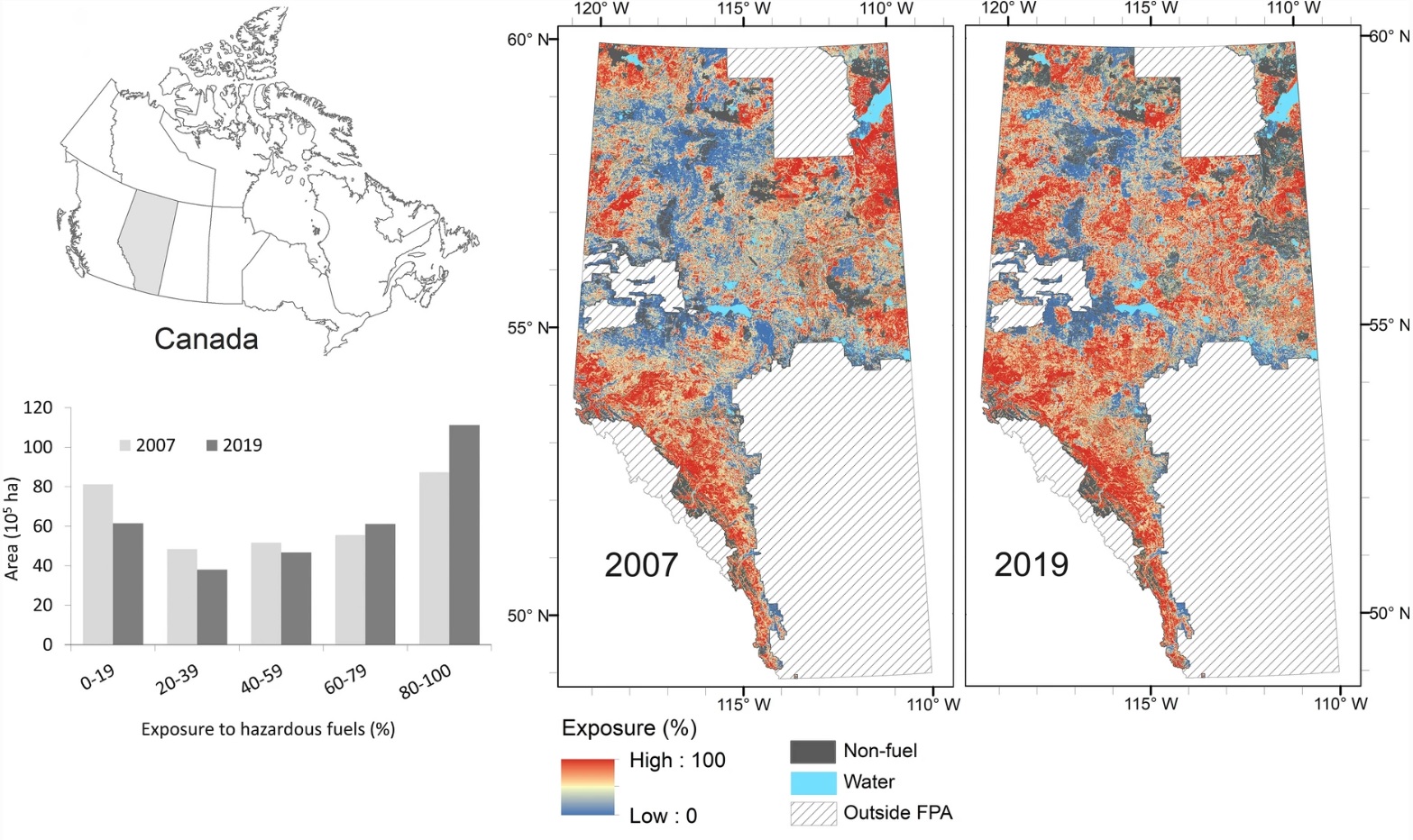
Hazardous fuel map to predict wildfires
By focusing on the fuel factor, which is more reliable and less subject to daily changes compared to weather and ignitions, researchers at the University of Alberta are predicting wildfires using geographic information systems. They analyze the connectivity and orientation of fuel patches. Read more here.

Canadian Wetland Inventory
To fill the lack of a comprehensive wetland inventory in Canada, The Canadian Wetland Inventory (CWI) was established in 2002 as a collaborative effort between DUC, Environment Canada, the Canadian Space Agency, and the North American Wetlands Conservation Council. Since then the mapping techniques for wetlands have been continuously improved, taking advantage of advancements in machine learning and the availability of high-resolution satellite imagery and LiDAR data. Read more here.
Achieving NG9-1-1 compliance; City of Edmonton journey
In a recent webinar, Brandon Mol, Manager of the Geospatial Information Program at City of Edmonton, shared biggest challenges, mandates, accomplishments and enhancements to prepare for Canada’s new Next Generation 9-1-1 (NG9-1-1) GIS data requirements. Read more here.

National Indigenous History Month with ArcGIS
Are you interested in exploring Indigenous history in Canada? Discover a diverse ArcGIS resources designed for Indigenous studies. These resources include a wide range of story maps and data layers in ArcGIS Online, covering topics such as Indigenous place names, population statistics, and the use of syllabic writing systems. Notably, Andre Boutin-Maloney, an educator, utilizes ArcGIS to facilitate Truth and Reconciliation education. So, don’t miss out on this incredible opportunity to expand your understanding and appreciation of Indigenous history. Check out the map and interesting details here
What are some fun ideas to wrap up the school year with GIS?
Whether you want to introduce your students to GIS, explore the new map viewer, or try out outdoor data collection, there’s something for everyone. Check out several tutorials available to change basemaps, experiment with clustering tools, and manipulate data related to Canadian railway stations. Read more here.


Be the first to comment