
- 3D Land Cover Data will be Available for Canada’s Largest Cities
- Fire-Smart Fuel Management with Bioenergy can Mitigate Wildfire Risks
- Blitz the Gap: A Canada-wide Initiative to Map Biodiversity
- 2025 G7 Leaders’ Summit: Canada’s Chance to Lead on AI Policy
- Government of Canada Invests in New Airborne Sensing Lab
- Canada and European Space Agency: A Partnership that Works Well
3D Land Cover Data will be Available for Canada’s Largest Cities
Canadian company Ecopia has announced the creation of 3D land cover data for Canada’s largest cities. High-precision map data is now readily accessible in 40 of the largest cities in the country. This availability, from the global leader in AI-based mapping, is part of a contract with the Government of Canada aimed at creating standardized 3D mapping data for the country’s major urban areas.
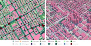
This feature not only removes the labor-intensive and time-consuming task of manually digitizing maps but also enables quick updates of geospatial databases to reflect real-world changes. Additional cities will soon be added, resulting in a first-of-its-kind visual representation of Canadian population centres.
Read the full article here: Ecopia AI Delivers Off-the-Shelf 3D Land Cover Data Across Canada’s Largest Cities — Ecopia AI
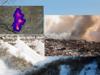
Fire-Smart Fuel Management with Bioenergy can Mitigate Wildfire Risks
A recent study found that integrating bioenergy and fire-smart fuel management can be a win-win solution for communities that suffer energy instability and wildfire vulnerability, as wildfires threaten an increasing number of towns across Canada. The aim of this research is to find ways to combine bioenergy development with wildfire prevention strategies. Specifically, the study will:
- Identify communities in Canada that rely on diesel and are at high risk for wildfires;
- Assess the biomass available from fuel treatments (BAFT) and fuel treatment areas (FTA) at the community level that could serve as feedstock for bioenergy; and
- Prioritize communities that can also fulfill their annual energy needs.
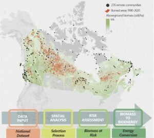
A distinctive framework that integrates a national environmental remote sensing dataset with community-based information is created to obtain consistent spatial analyses for Canada.
Full article here: Integrating fire-smart fuels management with bioenergy benefits remote and Indigenous communities in Canada | Communications Earth & Environment
Blitz the Gap: A Canada-wide Initiative to Map Biodiversity
‘Blitz the Gap’ is an initiative under the global iNaturalist program that gathers data from across the globe. Anyone can participate by uploading geo-tagged images of plants and animals through the iNaturalist platform. An AI-driven tool offers an initial identification, which is subsequently verified or adjusted by human specialists.
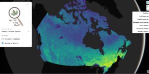
This Canada-wide initiative is a coordinated project by the Quantitative Biodiversity Lab at McGill University in collaboration with researchers across Canada, including key partners at the University of Victoria and Simon Fraser University.
Full article here: https://www.miragenews.com/citizen-science-maps-canadas-biodiversity-1469799/
2025 G7 Leaders’ Summit: Canada’s Chance to Lead on AI Policy
As the host of the G7 in June 2025, Canada can advocate for a significant international agreement. This could include establishing common standards for open datasets, developed with contributions from AI developers and experts across various fields.
Canada’s initiative to develop “next-generation data centres” aims to establish the foundation for globally competitive and ethically managed AI. These facilities are crucial for the responsible training, validation, and deployment of modern AI systems.
A primary objective should be to unite stakeholders around a framework that emphasizes the ethical, accessible, and well-structured development of datasets, particularly in critical areas such as healthcare, climate science, and materials research, frameworks. Implementing these measures would position the G7, particularly Canada, as a leader in promoting AI that aligns with democratic values, beyond just commercial and geopolitical interests.
Read the article here: Canada has a chance to lead on AI policy and data governance at the 2025 G7 Leaders’ Summit
Government of Canada Invests in New Airborne Sensing Lab
The Pacific Economic Development Agency of Canada (PacifiCan) has announced a funding allocation of $1.35 million for the University of British Columbia’s Okanagan campus (UBCO) to establish the first airborne sensing laboratory in Western Canada.

This facility will assist small and medium-sized enterprises in British Columbia in developing remote sensing technologies for purposes such as environmental monitoring, security, and hazard detection.
Several important collaborators of the lab are local businesses focused on creating artificial intelligence (AI) software that processes sensor data, contributing to the enhancement of the Okanagan’s expanding digital technology industry.
Read article here: Government of Canada invests $1.35 million in new airborne sensing lab so local companies can develop cutting-edge technologies – Canada.ca
Canada and European Space Agency: A Partnership that Works Well
For almost fifty years, the Canada-European Space Agency (ESA) Cooperation Agreement has facilitated the advancement of Canadian innovation beyond borders.

Across the country, Canadian companies are pushing into the European ring, with 63 different Canadian firms providing technology, services, or science to ESA missions. They have been joined by 25 postsecondary institutions, four research organizations (including the National Research Council of Canada), and two federal departments: Environment and Climate Change Canada and Natural Resources Canada.
Full article here: Canada and the European Space Agency: A Cooperation Agreement that keeps on delivering | Canadian Space Agency


Be the first to comment