
Western Canada has been experiencing extreme fire conditions following an intense heatwave since late June. According to BC Wildfire Service, 243 wildfires are currently burning in British Columbia.
Due to the fire threats, many residents have received evacuation alerts to get prepared to leave their homes on short notice. Local emergency officials asked some of them to leave the area immediately. According to Emergency Info BC, 87 evacuation alerts and 62 evacuation orders have been issued as of July 28, 2021.
During wildfire season, having access to real-time data is crucial to inform decision-makers, emergency officials, first aid respondents and the general public of wildfires’ location and situation, current evacuation alerts, air quality, roads condition and more.
Following, are some of the freely available location based resources that provide up-to-date wildfire related information for Canada and British Columbia.
FireSmoke Canada
FireSmoke Canada portal provides essential information about wildfire smoke for health and safety experts, emergency officials, researchers and the public.
This portal represents the two-day BlueSky Canada smoke forecast on an interactive map. BlueSky system, a Wildfire Smoke Prediction Model, is hosted and run by the University of British Columbia Weather Forecast Research Team.
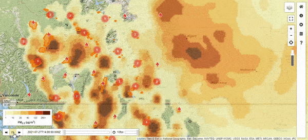
Detailed information about the BlueSky Canada system is available here. BlueSky Tutorials can be found here
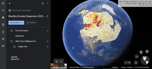
There is an option on this portal to download the KMZ file and display the wildfire smoke data on Google earth.
The image shows the FireSmoke Canada data on Google Earth. The downloaded KMZ data can be imported into Google Earth using the Projects icon > “New project” > “Import KML file”.
View the current fire forecasts for Canada on firesmoke.ca
Canadian Wildland Fire Information System
The Canadian Wildland Fire Information System (CWFIS) is one of the key components of The Fire Monitoring, Accounting and Reporting System (FireMARS) that is developed at Natural Resources Canada by the Canadian Forest Service and the Canada Centre for Mapping and Earth Observation, with support from the Canadian Space Agency (NRCan).
CWFIS observes fire danger situations, fire events and weather conditions across Canada to produce daily fire weather and fire behavior maps throughout the year and hotspots maps during the forest fire season. In addition, the system uses satellites for fire detection.
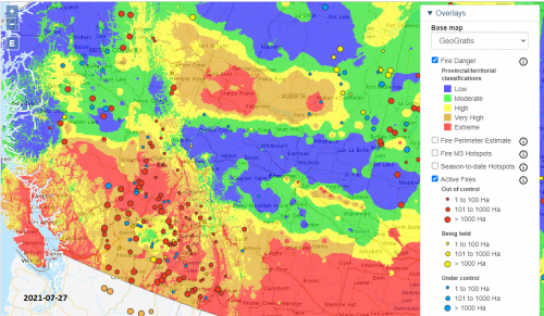
CWFIS’s interactive map displays the most recent fire danger condition across Canada. The colours on the map show fire danger classifications from low (blue) to extreme (red).
View this interactive map here.
The screenshot of the interactive map on July 27th shows most areas in the south of British Columbia, Alberta and Saskatchewan are red which represents extreme fire danger. The red circles on the map show out-of-control active fires.
Digital Twin of News
The Digital Twin of News (DToN) is designed and funded by the European Space Agency and executed by Sinergise. The Sentinel Hub services are used for processing satellite imagery.
The DToN combines news of extreme natural events such as wildfires with Earth Observation (EO) data to provide an interactive experience.
The right side of the DToN portal is a designated area for event-related news. On the selected news page, wildfires satellite imageries of two different dates are displayed for comparison. The “Explore EO data” button is a link to the Sentinel Hub EO Browser to represent several visualization options for wildfire satellite data. Check out my video below to see how this interactive portal works.
B.C. Wildfire Dashboard
Many wildfires have been reported in the province of British Columbia since late June. Some of them are particularly visible or currently causing a threat to the safety of British Columbians. They are called wildfires of note.
The BC Wildfire Service produced an interactive dashboard that comprises the province map and critical wildfire information such as the number of active fires, a list of communities that received evacuation alerts and orders and more.
The map shows when and where the wildfire events occurred and detailed information on the size and cause of fires burning across the province. Visit BC Wildfire Dashboard here.
EmergencyMapBC
EmergencyMapBC, managed by EmergencyInfoBC, provides essential information for the public during emergency events.
The map shows not the location of wildfires, evacuation alerts and orders but also emergency related information such as the location of ESS Reception Centres (for help during an emergency) and ESS Resiliency Centres (for support after an emergency) for those affected by events.
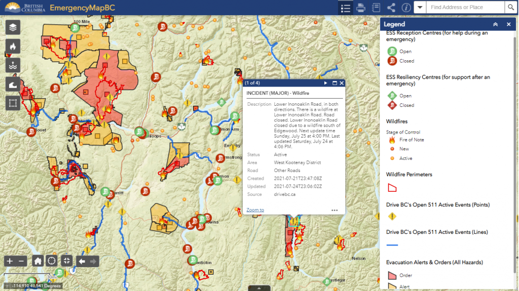
Besides, EmergencyMapBC displays information for motorists on roads conditions in case of construction, incidents such as wildfire, weather conditions that might cause limited visibility with smoke and more.
View EmergencyMapBC for more information
The screenshot on July 24th of the interactive map shows emergency related icons and information for parts of the BC with the most intense fires.
BC Air Quality Health Index
Wildfire smokes cause poor air quality that affects everybody’s health. Castlegar in BC has been marked very high risk on the BC Air Quality Health Index portal for today and tomorrow. This source also offers health messages for all and particularly at-risk populations to reduce or avoid outdoor activities.
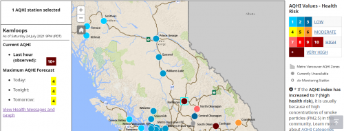
The image shows the Air Quality Health Index of Kamloops in BC on July 24, 2021, was 10+. On the right side of the map, the 10+ AQHI is marked as a “very high” health risk.
View the current BC air quality data on this interactive map
DriveBC map

DriveBC is the British Columbia Ministry of Transportation and Infrastructure’s traveller information system.
This portal presents current information on the road conditions naming limited visibility due to wildfire smoke. It also provides details on incidents affecting traffic.
The image shows the road conditions for the south part of the province on July 27, 2021. The red triangles on the map indicate Major Incidents such as forest fires. Read more information about the icons on the map here
View Drive BC map and resources on drivebc.ca
Other sources
Digital Twin of the News — AI enhanced news and EO data just a few clicks away


Be the first to comment