
Is wildfire spread random? It looks like that, but it isn’t.
In fact, it follows the invisible geometry of landscapes: slopes, vegetation density, and wind corridors. Managing these patterns is a spatial problem.
A recent study in Alberta tackled this challenge by treating a forest as a connected network of fuel patches and then asking a geospatial question: Which connections matter most if we want to slow the fire down?
Can the fire be disconnected from the forest network?
Forest as a Fuel Network Graph
A common method to mitigate wildfire risks involves strategically clearing flammable vegetation from a strip of land to prevent the spread of fire. This method is called a fuel break. Hence, it acts like a barrier to protect firefighting efforts and communities by reducing the density of dead leaves and dry branches. This significantly decreases the intensity and speed of wildfire spread.
One way to picture this is to think of wildfire as water flowing through pipes: if you shut off a critical valve, you can stop the flow. In the same way, a well-placed fuel break disrupts the fire’s path, preventing it from spreading freely across the landscape.
Although a fuel break may initially seem like a radical measure, the land typically recovers and replenishes with fresh foliage within a year or two. Some woodlands are so dense that small fuel breaks do not significantly disturb the habitat of native species.
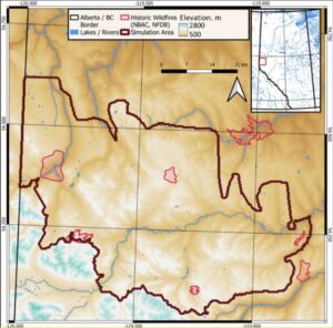
This landscape encompasses the upper foothills and lower subalpine ecoregions of the Rocky Mountains. Situated within the Peace River basin in Alberta, the area features moderate elevations in its southern section adjacent to the Rocky Mountain range.
How about envisioning the forest-covered landscape in the study area as a fuel network graph with nodes and links? Each node on this graph is a cluster of multiple forest patches. Such nodes are connected to other such nodes without any fuel break in the middle, making it possible for the fire to jump faster from one forest patch to another.
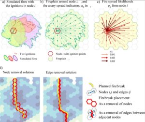
According to the study, utilizing a hexagonal node grid to reduce connectivity bias that can arise from using irregularly shaped polygons of varying sizes to define forest stands.
Firebreak allocation decisions were assumed to be made at the scale of these hexagonal nodes, with the hexagon size selected to be large enough for the assigned treatments to effectively limit the spread of high-intensity fires in the region.
The layout and dimensions of the fire plain are influenced by the arrangement of fuels, the landscape, and local weather conditions, all of which can either facilitate or hinder the spread of fires. This aligns with a common approach to managing fire-prone areas by disrupting critical fire spread routes to decrease fuel continuity between forest sections.
With limited human and financial resources, this type of compartmentalization of woods can be achieved efficiently using an AI model and a simulation process.
Modeling the Wildfire Behaviour
The study used the Burn-P3 model. Burn-P3 (probability, prediction, and planning) is a spatial fire simulation model utilized in Canada for land management planning and wildland fire studies.
The model has simulated 60,000 stochastic wildfires, incorporating fuel, terrain, wind, and weather data to capture realistic fire spread patterns. Firebreak units of 2.15 km wide were designed to resist spotting from high-intensity fires.
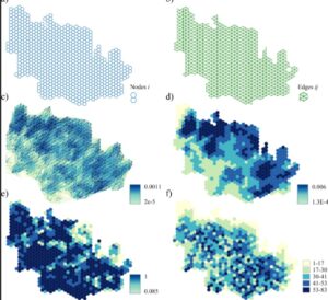
From the simulations, a fuel network of hundreds of nodes and nearly a thousand potential fire spread connections was constructed to estimate ignition and spread probabilities.
Fire Break Allocation Solutions
The study found that different strategies produced different strengths in reducing wildfire risk. Node- and edge-removal approaches (problems 1–4) were the most effective overall, creating clear compartments and reducing fire spread potential, especially at lower budget levels where the biggest gains were made. Problem 5, which minimized the largest fireplain size, achieved strong compartmentalization while also targeting high-risk nodes.
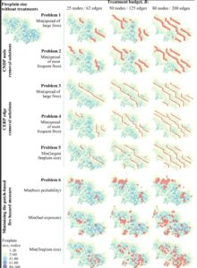
In contrast, problem 6 solutions that relied on patch-based hazard measures were less effective, as they produced scattered or isolated treatments rather than continuous firebreaks.
Overall, the best results came from approaches that fragmented the landscape into well-spaced compartments, showing that targeted network-based firebreaks can significantly limit both fire spread potential and fireplain size.
Compartmentalized Edge Removal Problem
The study evaluated a novel method called the Compartmentalized Edge Removal Problem (CERP). Rather than just assessing fire risk at individual patches, CERP tracks how fire actually moves across landscapes by considering vegetation, terrain, and wind pathways.
By pinpointing and “cutting” key links within this network, the approach creates compartments that help slow down fire spread. Findings demonstrated that network-based methods like CERP are significantly more effective at limiting fire propagation compared to traditional hazard assessments.
While firebreaks are not foolproof—fires can still leap over well-designed barriers during extreme weather—when combined with prescribed burns, suppression efforts, and adaptive management, these models assist land managers in implementing smarter, more effective fuel treatments. The aim is not to create a fireproof environment but to develop a landscape that is better able to withstand fires.
This research indicates that Canada can create smarter, more cost-effective fire management strategies by using AI-driven network analysis to tackle the rising frequency of wildland fires.


Be the first to comment