
Utility digital transformation already driven by demand for Distributed Energy Resources (DER) and Advanced Distribution Management System (ADMS) has recently accelerated due to COVID-19. These systems need Digital Twins – grid transformation like this requires utilities to manage data from source to consumer 100% digitally. Utilities must now capture high-fidelity, high-quality data faster to feed these network-hungry operational systems. However, the use of paper in the construction as-builting process remains a pervasive problem. This article will explore why as-builting remains paper-based today and present case studies on how digital construction can stitch together existing utility technologies to create the elusive Digital Twin utilities need.
Digital Bookends
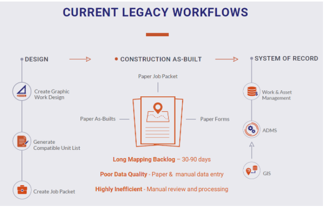
As-builting takes place during the Design>Construction>GIS workflow that manages the construction of network infrastructure and updating enterprise and operational systems. Utilities have spent decades and millions of dollars digitizing the Design and GIS sides of this equation, pouring investments into graphic work design (GWD), geographic information systems (GIS), enterprise asset management (EAM), work management systems (WMS) and mobile workforce management (MWFM). GIS has clearly established itself as the mission-critical system of record for spatial assets tasked with managing spatial asset and network data and sending it to ADMS. Esri has responded to this need with the advanced network modeling capabilities of the ArcGIS Utility Network. In turn, many GWD vendors followed suit offering support for the Utility Network in their design products. Recent market activity shows that utilities are focusing the bulk of their attention and budgets on adopting the Utility Network and procuring GWD tools to drive better data into their GIS. With this approach, utilities will end up with a set of digital bookends – digital GWD tools on one side and digital GIS on the other…a mound of paper in the middle. The widespread use of paper during construction breaks this digital chain and represents the last gap in this workflow.
Difficult Problem
With the push for digitalization forces utilities to assess all workflows involved in driving high-quality data to their GIS, a logical question follows – Why haven’t utilities digitalized construction yet? The answer – it is a very difficult (hidden) problem involving various personas with no clear owner. It is difficult due to the numerous different personas involved who work in different teams, speak different “languages” and have different goals. There is also lack of awareness and ownership of the as-builting process. Utilities say it takes 30-90 days to get paper-based as-built information into GIS (recent industry report confirms this) – they seem to be fine with this performance and surprisingly unmotivated to address it.
The days of this legacy workflow are numbered. Safety and compliance pressures are growing – high profile incidents underscore the need for improved design workflows and better mapping of underground utility assets. In the COVID-19 era, utilities are seeking paperless technology that improves field worker safety. Some regulatory agencies now require digital as-builts with high accuracy from utilities and their contractors with similar efforts growing around the world. There is an urgent need for a solution purpose-built for the construction crew persona that matches their workflow that enables utilities to capture a complete & accurate accounting of field constructed assets, create a Digital Twin and feed ADMS in a timely manner.
Does Such a Solution Exist?
Yes it does. Advances in mobile applications, cloud technology and sensors have made a user-friendly digital as-builting solution a reality. The Locusview Digital Construction Management solution solves this difficult problem by establishing a new streamlined and paperless vision for the Design>Construction>System of Record workflow – where paper job packets, as-builts and forms are replaced by a digital solution. At Locusview we developed a paperless digital construction solution that fills the gap between design and GIS, guided by a mobile-first philosophy focused on the construction crew end-user persona.
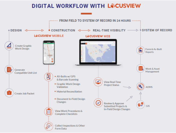
It starts with design in the office using GWD and WMS to generate the construction sketch, bill of materials (BOM) and cost estimate. This gets passed digitally from the designer to the crew using Locusview Mobile to capture digital construction data with GPS & barcode scanning during construction. Office personas can view, monitor and track construction progress in real-time via Locusview Web. Active construction can also be shared directly with ADMS before posting to GIS increasing operational awareness and safety. Once construction is done and data collection is confirmed complete, the high-fidelity data captured in the field is integrated seamlessly to GIS, WMS, EAM and ADMS. When we achieve this, we eliminate re-work and duplicate data entry, reduce the mapping backlog, improve data quality and reduce time spent on manual data reviews.
How did we do this? Our company was born out of a deep research mindset and R&D approach – working hand in hand with utilities is imprinted in our DNA. We partnered with the industry and utilities to develop best practices and productize them. Our mobile-first philosophy focuses on the construction crew end-user resulting in a mobile application designed specifically for field crew personas that matches their workflow. In other words, construction crews will actually use it!
Our customers are realizing tangible business value using the Locusview Solution. Today they are seeing ~70% reduction in the time it takes to get data from the field into their GIS, ~20% time savings in the field and during job close-outs and ~50% cost savings from digital data collected by a construction crew. We estimate tangible savings of double digits over paper workflows with the added benefit of higher accuracy data overall.
Conclusion
Utilities have spent millions digitizing the Design>Construction>GIS workflow only to end up with digital bookends caused by the pervasive use of paper during construction. Digitizing this last gap in the workflow is a very difficult problem. Locusview’s Digital Construction Management solution solves it by matching construction crew workflows solving the persona problem. Crews realize daily business value from the industry best-practices we developed and productized – we have done all the hard work pioneering the use of technology to solve this difficult problem.


Be the first to comment