Natural disasters, to say the least, have jeopardized the livelihood of millions, and the Rohingya refugees in Bangladesh are not unfamiliar with the displacement and famine that follows (The World Bank, 2021). The 1.1 million Rohingyas are in dire need of shelter and aid, accessibility to which would have become an issue during the pandemic, if not for the Local Government Engineering Department (LGED) promptly constructing disaster shelters that serve multiple purposes and are climate-resilient (The World Bank, 2021). This project was one of the many World Bank projects this year that relied on innovative spatial tools to provide shelter and support in remote, during the lockdown (The World Bank, 2021).
Geographical Information System (GIS) and Unmanned Aerial Vehicle (UAV) or Drones paved the way for designing multi-storeyed shelters that would serve the complex needs of the Rohingya refugees (The World Bank, 2021). The implementation process involved the superimposition of Global Positioning System (GPS) coordinates over georeferenced images collected from UAVs, which provided information on the layout and orientation of the disaster-struck locations (The World Bank, 2021). Once the spatial data was obtained, the real challenge was the execution of this evidence-based project without the conjugation of the workforce in one place (The World Bank, 2021).
Evolution of UAV/Drone Technology in Disaster-Related Mortality Reduction
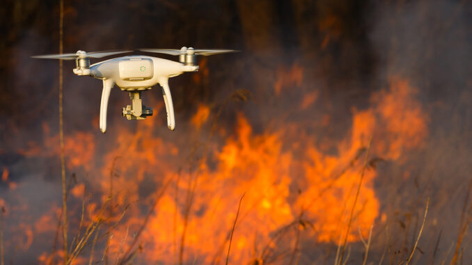
But increasingly, UAVs are gaining popularity amongst firefighters due to their portable and reliable nature in identifying the fire hotspots, degree of damage, location of survivors, especially in areas that are remote or inaccessible (Dugbazah, 2021). NEC’s new drone prototype, SARDO (Search and Rescue Drone), is programmed to act as a mobile cellular base that detects disaster victims from signals emitted by their smart mobile phones (Intelligent Aerospace, 2021). SARDO by far outdoes a regular GPS device that needs a cellular network tower to enable tracing, which may not be accessible or have coverage in certain sites. Thus, by having a cellular base station within the UAV itself, SARDO can track the unique identification number of the victim’s smartphone SIM card to detect their location (Intelligent Aerospace, 2021).
That is, Disaster Management is becoming more accessible with the advancement and incorporation of GIS and UAV, which is why long-term supervision of projects on public health, telecommunication, water and electricity resources are increasingly opting for these advanced tools (The World Bank, 2021 and Dugbazah, 2021).
Proactive UAV/Drone Technology in Risk Assessment of Disaster-Challenged Areas
Furthermore, the Disaster Management team is constantly involved in assessing risks, planning mitigation, adaptation and building resilience through the utilization of ESRI’s GIS products (ESRI, 2021). Data on infrastructure, locations of natural hazards, anthropogenic threats, and demographics are layered through GIS to filter the areas that require more resources, which helps to plan equitable short- and long-term emergency programs (ESRI, 2021).

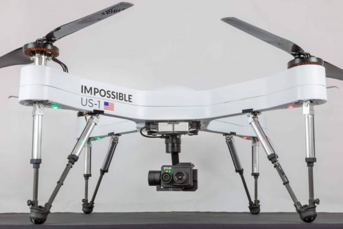
The Impossible Aerospace US-1, as shown in Figure 1, is esteemed as the UAV that can withstand a harsher environment and attend to operations on disaster management, firefighting and can cover critical infrastructures (Nichols, 2021). This drone is best for disaster response due to its customizable capability to lift more than 6 pounds and have 75 minutes-long flight time (Nichols, 2021). As UAVs and GIS are specifically improving in Disaster Management, more organizations are being encouraged to step out of traditional practices and reaching the unreachable.
References
Chan, S. (2018). Drones and disaster relief. The Network.
Dugbazah, J., Seke, L., Glover, B., Mbuli, B., & Kungade, C. K. (2021). A Bird’s-Eye View: The Application Of Drone Technology In Rapid Disaster Response Management: AUDA-NEPAD.
ESRI. (2021). GIS in Emergency Management Operations: Gain Real-Time Data Insights.
Intelligent Aerospace. (2021). NEC drone technology locates missing natural disaster victims by mobile phone.
Nichols, G. (2021). Best surveillance drone in 2021. ZDNet.
The World Bank. (2021). In Bangladesh, drone and GIS mapping tools come to the aid of designing disaster shelters during COVID-19.


Be the first to comment