
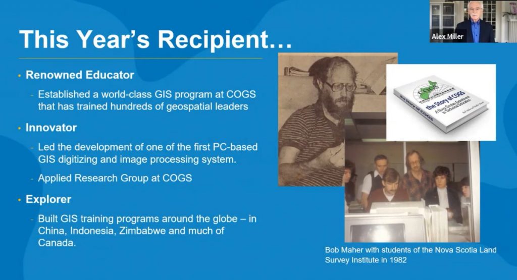
Renowned educator and innovator established a world-class GIS program that has trained hundreds of geospatial leaders
On GIS Day 2021, Esri Canada President Alex Miller presented Dr. Bob Maher with the Roger F. Tomlinson Lifetime Achievement Award, in recognition of his many achievements in expanding the use of geographic information system (GIS) technology. Dr. Maher established a world-class training program for GIS programmers at the College of Geographic Sciences (COGS) in Nova Scotia, where he was Senior Research Scientist responsible for the Applied Geomatics program.
The award recognizes individuals for their outstanding achievement and contribution to the GIS community during their career and was created as a tribute to Dr. Roger F. Tomlinson O.C., a visionary Canadian geographer who conceived and developed GIS and became known as the ‘father of GIS’.
“Bob has always known that geography is central to understanding our world and he trained hundreds of people to use the lens of geography to understand problems. The intensive training program he created at COGS has helped the college become recognized as the gold standard for teaching of GIS. The program has significantly contributed to Canada’s rich pool of highly qualified GIS professionals.”
Alex Miller, president, Esri Canada.
“GIS is central to addressing the significant environmental degradation that the world faces today and I am proud to have trained people who are all around the world, using GIS to help address it.”
Bob Maher
At the very start of my career I had the privilege of working with Bob during my time at the Applied Geomatics Research Group (AGRG) at COGS which he founded and managed. Bob has continued to contribute to the community by sharing his writing on GoGeomatics Canada (His articles here) and on another site here.
Jonathan Murphy – Managing Director GoGeomatics Canada
Dr. Maher has also taught far beyond Canada’s borders. He has conducted intensive GIS training courses in China, Indonesia and Zimbabwe, all for international aid agencies. At various universities, he also taught Applied Mathematics, Quantitative Methods and Computer Mapping, Biogeography, Scientific Computer Programming and Computer Graphics, in addition to GIS. He is also an innovator who has worked as an applied research scientist for over 25 years. In Nova Scotia, Dr. Maher led a team who developed one of the first PC-based GIS digitizing systems. In Alberta, his team developed a PC-based integration of image processing and GIS. When Dr. Maher worked as a senior manager in the Ontario Ministry of Natural Resources (MNR), he was responsible for all aspects of GIS education and technical and management training at over 60 locations. In consultation with MNR technical staff, he produced a framework for corporate GIS training. He established partnerships with colleges, universities and the private sector. His work at MNR represented one of the most extensive and complex implementations of GIS technology in Canadian government.
About the Roger F. Tomlinson Lifetime Achievement Award
The Roger F. Tomlinson Lifetime Achievement Award was instituted in 2014 and is awarded to an individual for outstanding contributions to the GIS community over the course of their career. The award is named after GIS pioneer Dr. Roger F. Tomlinson O.C. (1939 – 2014), who conceived and developed the first geographic information system (GIS) for the Canadian federal government in the 1960s. He initiated, planned and directed the development of the Canada Geographic Information System to create the Canada Land Inventory, a geographic database still used today by municipalities for land planning. His innovation has enabled the development of modern mapping technology and techniques and established a multibillion-dollar industry employing thousands of people worldwide.
About Esri Canada
Founded in 1984, Esri Canada provides geographic information system (GIS) solutions that empower people in business, government and education to make informed and timely decisions by leveraging the power of mapping and spatial analytics. These solutions enable organizations to better manage their resources, plan their future and collaborate within and beyond their organization. Esri Canada’s products and services help advance successful digital transformation. The company serves 12,000 organizations from 16 offices across Canada and is based in Toronto. In 2019, Esri Canada achieved Platinum Club status with the Canada’s Best Managed Companies program by retaining its Best Managed designation for seven consecutive years or more. More information can be found at esri.ca.


Be the first to comment