
Humans and nature share a mutual existence, but our dependence on them far exceeds their need for us. The planet is experiencing a rapid loss of biodiversity and a mass migration of species in response to climate change.
Geographic Information Systems (GIS) and satellite imagery analytics have revolutionized how we monitor and understand the Earth’s changes over time. Properly classifying habitats by analyzing their distinct topography and geographical features is on the rise. By studying these environments across different periods, we can make well-informed decisions for sustainable biodiversity management, benefiting both people and wildlife.
Whistler’s Vision to Protect Nature
Whistler, British Columbia, is a town north of Vancouver. It is home to a vast variety of biodiversity, wetlands, old-growth forests, and habitats suitable to many different species of animals.
Thanks to technological advancements, the Resort Municipality of Whistler (RMOW) has consistently upheld its commitment to preserving the environment, land, water, and native biodiversity. The mapping of species and their habitats has significantly advanced conservation efforts. The next phase in this initiative involved implementing strategies to safeguard the habitats of high-priority species.
The Priority Habitat Framework (PHF) is a high-level plan of action designed to promote land-use planning and conservation. The 2024 updated version is the most comprehensive strategic plan, including an array of ecological maps, extended geographic range, comprehensiveness, and accurate mapping. The purpose of the update was to provide better tools for environmental planning.
This journey of analysis discovered 20 distinct ecosystem- and species-based habitats. The available geographic information system maps include the RMOW’s first-ever species-based habitat maps for numerous species of local significance.
Improvements and Additions to 2018 Mapping
The priority habitat project comes with an exclusive version of 25 online maps classified as:
- One Priority Habitats Overview Map that aggregates all priority scoring
- 20 scoring layers including 9 types by ecosystem type and 11 Priority Habitat types by species; and
- Four non-scoring (information) layers – 3 Connectivity maps and a map showing Existing Conservation Areas.
Improved Habitat Classifications and Mapping
The 2024 Mapping Updates for the Whistler area focus on gathering all plausible information about the species and their habitat. This will eventually help prioritize the habitat.
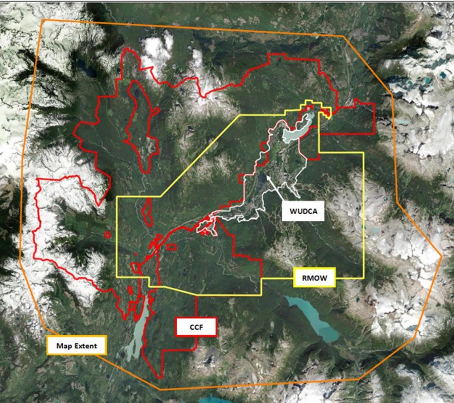
- An expanded geographic range that embraced the whole RMOW, including the Whistler Urban Development Containment Area (WUDCA) and the neighboring area influenced by economic, recreational, and forestry activity originating from Whistler.
- Lakes and wetlands are distinguished using explicit, biologically relevant definitions.
- Stream parts are rationalized so that they may be chosen as a single entity.
- “Shallow Shoreline” wetlands were initially identified in lakes.
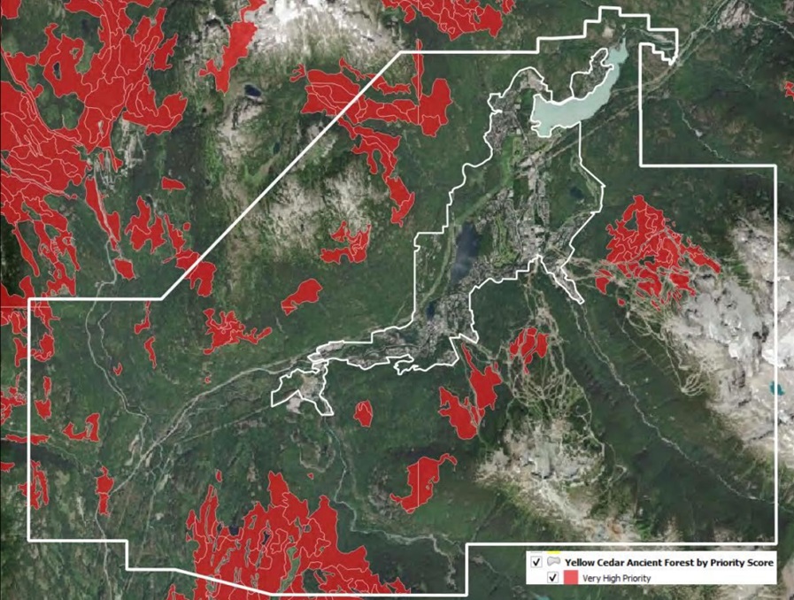
- More accurate (extra) mapping of ancient (>400 years old) woods, as verified by tree scoring.
- The provincial forest mapping is now up to date.
For the first time, the number of species were mapped online: for example, salmonid fish, tailed frogs, Western Toad and Red-legged Frog Breeding Ponds, and yellow cedars. Additionally, various existing suitability models for high-priority animals are updated.
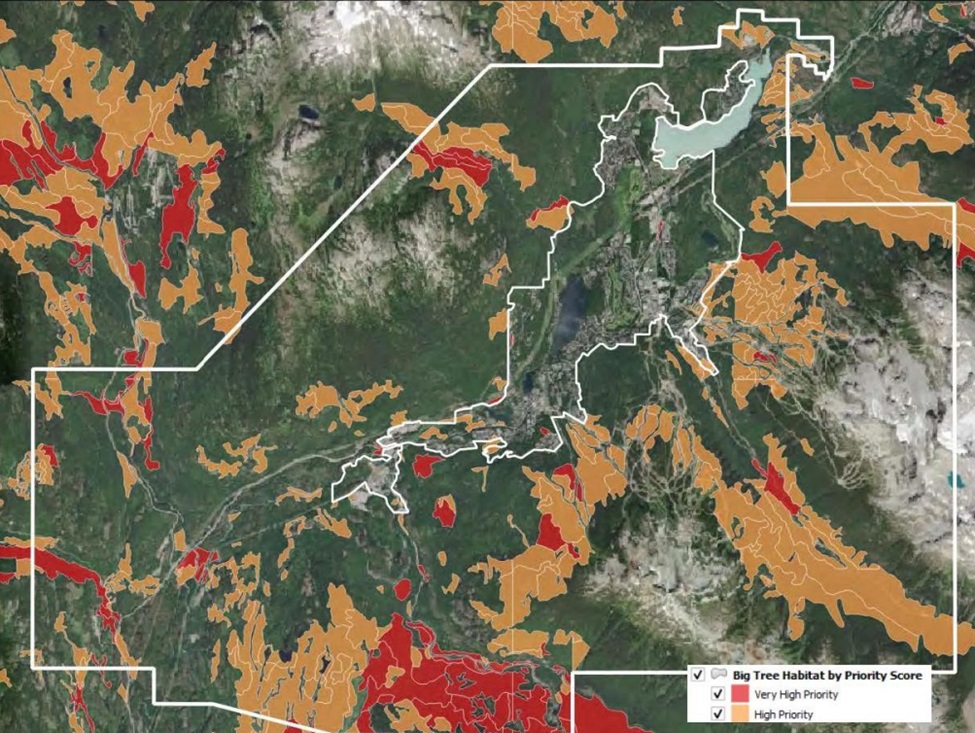
Two maps are available to help locate Whistler’s oldest forest (Yellow Cedar Ancient trees map) and unlogged forests with the tallest trees (Big Tree Forests map).
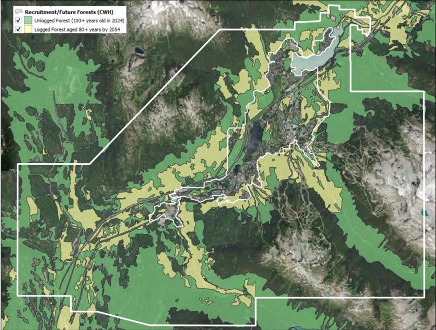
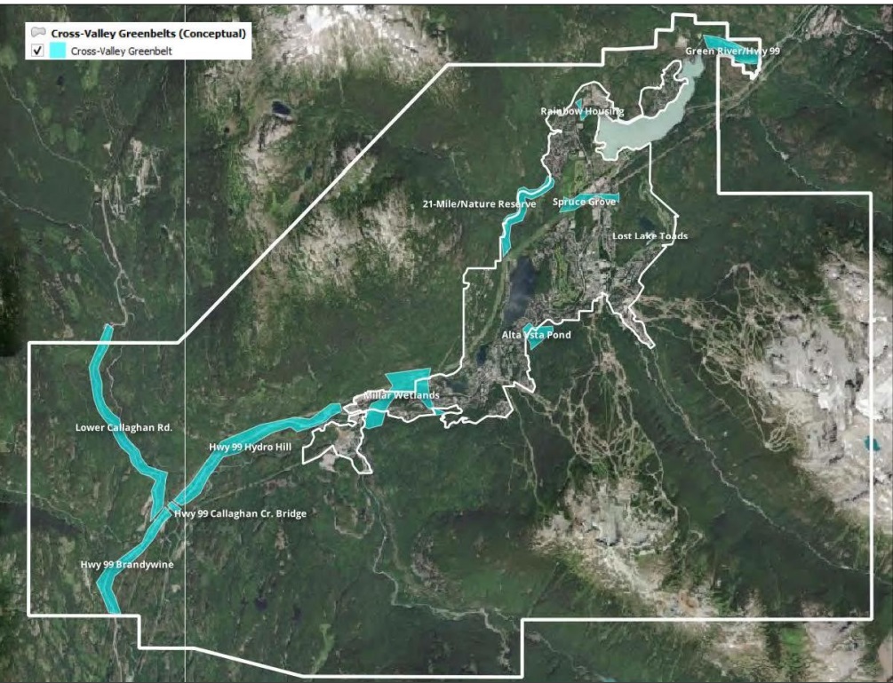
A set of three maps for connectivity planning : (i) Future Forest recruitment; (ii) Conceptual mountainside greenbelts; (iii) Conceptual cross-valley connectivity;
The Recruitment and Future Forests maps highlight how the connectivity and habitat value of second-growth (previously harvested) forests will expand over time, particularly in the next 30 years. It predicts which second-growth forests will be mature by 2054. The respective map for it sheds light on the range of area covered.
The objective is to determine regions that should be managed in a way that promotes habitat reconnection and enhanced habitat for a variety of priority species. Connectivity maps are not included in priority score ratings.
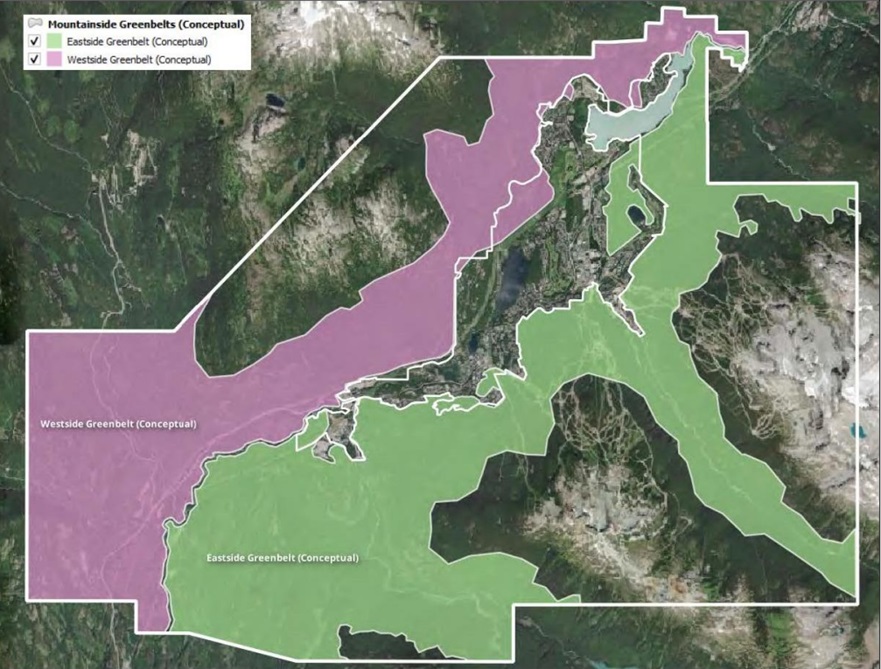
The conceptual greenbelts and cross-valley corridors are the areas on the map that represent extensive analysis of cross-valley corridors and illustration of potential greenbelts on the east and west mountainsides to represent the best opportunity to reconnect the forested landscape across the valley.
Over the following months, RMOW staff will acquaint themselves with the new mapping tool. In the long run, the PHF will be used to evaluate the state of specific habitat areas. Basically, keep the land under a continuous watch.
Updated maps can be explored here Whistler’s GIS Map
References:
https://www.piquenewsmagazine.com/local-news/whistler-priority-habitat-framework-9874664


Be the first to comment