
Which Countries are Mapping the Ocean Floor?
Significant progress has been made in Earth Observation around the world. Thousands of satellites currently observe our planet; about three-quarters of the Earth’s surface is influenced by human activity, and Aircraft-based LIDAR mapping is creating new models of the physical world in staggering detail. However, our collective knowledge of the ocean floor still has surprising blind spots. A few countries have made efforts in their subsea activities with Japan leading the trail at 97.7% Exclusive Economic Zone (EEZ) mapped, closely followed by the United Kingdom at 90.6%, Canada comes 9th at 38.8% EEZ zone mapped. “A project called Seabed 2030 has the ambitious goal of mapping the entire ocean floor by 2030. The organization is collaborating with existing mapping initiatives in various regions to compile bathymetric information (undersea map data)”.
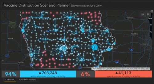
Vaccine distribution will be a logistical nightmare; how geospatial technologies can help.
COVID-19 Vaccine distribution will be a logistical nightmare as the exercise would require planning for massive manufacturing, supply chain and logistics, prioritization of population and tracking progress. However, geospatial technologies can be at the core to help. Esri has partnered with modelling startup Epistemix to develop intelligent, hyperlocal estimates about the number of vaccine doses needed in each area to achieve herd immunity from COVID-19.
Drones to deploy across Sydney’s northern beaches to monitor overcrowding
As Australia approach the summer months, drones are being adopted across 20 Northern New South Wales (NSW) beaches to ensure that people are COVID compliant. A four-month trial will start on November 14 as a partnership between Surf Lifesaving NSW (SLS NSW) and Northern Beaches Council (NBC). These drones will provide SLS NSW and the NBC authorities with real-time information on the number of beachgoers at popular destinations to avoid overcrowding. This project aims to keep the popular beaches and parks open so that visitors and locals can fully enjoy summer. The data will be made publicly available on the beachside website and mobile app to allow beachgoers to make smart decisions about where to visit.

Understanding a map creates a new sort of relationship with the outdoors
Despite the COVID pandemic and the restrictions on most activities, people do seem to be walking in nature. This is evident from an increase in map sales and the use of OS Maps Get Outside adventure planning app by 78% since February with about 3.5 million active users.

Software Without Geospatial Power Has ‘Lost’ The Plot
The act of global containment through various national lockdowns and quarantine has driven the increased use of world mapping data and geospatially aware software this year. Several Coronavirus news reports released statistics presented through colour-coded maps to deliver accurate location-based data, and create a geospatial awareness of current occurrences. The Ordinance Survey software and data team suggests that barriers to accessing geospatial data have been lowered. Hence, software developers in commercial organizations should be more open to including location-aware information into applications which we use daily.


Be the first to comment