
- Digital twin technology brings Pompeii to life
- How Satellite Data Is Helping Tackle the Urban Heat Issue
- NV5 closes acquisition of L3Harris’ geospatial division
- NISAR satellite to map Himalayas’ seismic zones
- Chinese scientists let AI control satellite, it takes ‘closer look’ at specific spots in India, Japan
- Washington, DC, Pursues Equity and Transparency in Vision Zero Campaign
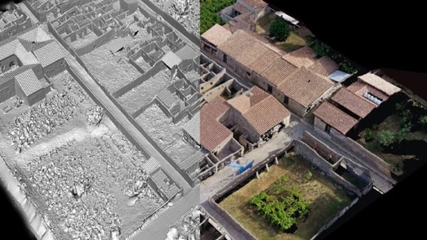
Digital twin technology brings Pompeii to life
A team of researchers and engineers are using digital twin technology to recreate the ancient Roman city of Pompeii in Italy. The project involves creating a 3D model of the entire city, which was destroyed by the eruption of Mount Vesuvius in 79 AD. The team is using advanced laser scanning technology and photogrammetry to capture the physical details of the city and its artifacts. Read More Here.
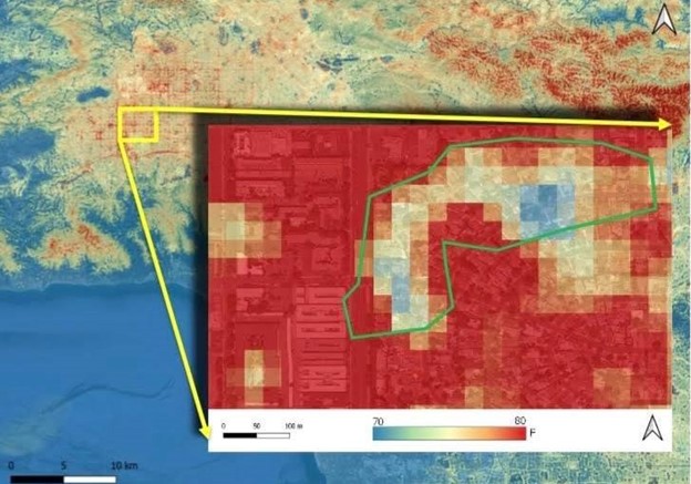
How Satellite Data Is Helping Tackle the Urban Heat Issue
If you’re interested in learning more about how satellite data is being used to address the issue of urban heat, this article discusses that. It highlights the use of satellite data to measure urban heat islands and identify areas that need attention. It also explains how this data is being used to create heat maps and provide information to city planners and policymakers to develop solutions. Read More Here.
NV5 closes acquisition of L3Harris’ geospatial division
The acquisition of geospatial data analytics technology by NV5 and L3Harris is an important development in the field of geospatial technology and analytics. The acquisition will enhance NV5’s geospatial capabilities and increase its access to advanced technology. The new technology will allow for better data analytics and processing, leading to more accurate and efficient geospatial solutions. Read More Here.
NISAR satellite to map Himalayas’ seismic zones
The Indian Space Research Organization (ISRO) and NASA will jointly launch the NISAR satellite in 2023 to map the Himalayas and the seismic zones of India. The satellite will provide valuable data for studying natural disasters such as earthquakes, floods, and landslides. The satellite will use synthetic aperture radar to capture images of the Earth’s surface and provide data on deformation, ice sheet movement, and changes in vegetation. The mission aims to improve understanding of the Earth’s ecosystem and enable better disaster management strategies. The NISAR satellite is expected to facilitate scientific research and improve the accuracy of climate models. Read More Here.
Chinese scientists let AI control satellite, it takes ‘closer look’ at specific spots in India, Japan
Chinese scientists have successfully allowed artificial intelligence (AI) to control a satellite to take a closer look at the Indian and Japanese regions. The satellite named “Xiaoxiang-1 08” is a low orbit satellite used for remote sensing, and the researchers used AI technology to optimize its movements and adjust the parameters of its sensors. Read More Here.

Washington, DC, Pursues Equity and Transparency in Vision Zero Campaign
The District Department of Transportation (DDOT) in Washington, D.C., is using Esri’s ArcGIS platform to implement its Vision Zero initiative, which aims to eliminate all traffic fatalities and serious injuries in the city by 2024. The platform is being used to collect, manage, and analyze data related to traffic crashes, as well as identify high-risk areas and track progress towards the Vision Zero goals. By using data to inform policy decisions and targeting resources to areas with the highest need, the DDOT hopes to make the streets safer for everyone, regardless of transportation mode or neighborhood. Read More Here.


Be the first to comment