
With the passing of Earth Day this weekend, GoGeomatics Canada would like to celebrate our planet and highlight some of the critical ways that geospatial technology helps to make for a cleaner, greener Earth. While GIS technology has become an essential tool in protecting the earth, how it influences these efforts can vary from typical, expected ways like monitoring emissions and other earth systems to other, less conventional applications that are making a significant difference. In this article, we will discuss three traditional ways that geospatial tech is helping create a better, more livable earth, followed by a discussion in part 2 of three less conventional applications that are having a significant impact.
3 Conventional Earth-friendly Applications of Geospatial Technology
Greenhouse gas (GHG) emissions monitoring
Tracking greenhouse gases in our atmosphere is a new and critical part of climate science that can help us quantify and locate emission sources. With the 2016 launch of satellites like GHGSat’s “Claire” and NASA’s Earth Observing-1(EO-1), methane emissions could be tracked and quantified, allowing for the identification of emissions sources as small as individual oil and gas wells. This innovative technology also provided a failsafe for identifying emissions in remote regions that otherwise would not quickly be discovered by conventional means (i.e., leaking pipelines). While methane is one of the strongest GHGs, it has a short atmospheric lifetime, meaning it dissipates quickly (about 12 years) when compared to other gases such as carbon dioxide (300-1000 years) [1].
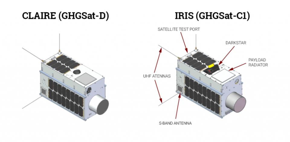
That makes the next generation of GHG monitoring satellites, such as the upcoming GHGSat-C10, so important. As the first commercial satellite with the capability for identifying emissions of long-lasting carbon dioxide at a single-site (25m) scale, the upcoming satellite will allow for attribution in the same ground-breaking way the earlier methane satellites did. As countries and regions work to meet emissions goals agreed upon in the Paris Agreement, understanding where these emissions come from is a non-negotiable first step towards acting.
Identifying high-risk forests to aid protection efforts
Like methods of GHG emission monitoring, we can also monitor our precious forests. And while the mapping of forests may consist of uses from tracking the condition of forests during drought, to monitoring the size of forests, especially for change due to deforestation and logging, one of the biggest risks they increasingly face is wildfires made more by climate change [2].
Knowing that dead and dying forests will burn easier and more wildly than healthy forests, scientists use satellite analysis to identify areas where drought or climate change creates an elevated risk for rampant wildfires. Some recent work out of Stanford is also helping to identify high-risk areas long before they become high-risk. The geospatial analysis revealed that nearly one-fifth of conifer forests in California’s Sierra Nevada range no longer stand in a climate suited to their needs. This leads to the inevitable fact that these forests will slowly die, increasing their susceptibility to wildfire events [3].

This technology is proving especially useful in identifying high-risk forests however, as climate change increases the likelihood of these events, Canada is also preparing by launching a dedicated WildFireSat in 2029 to help combat these deadly wildfires and protect our forests.
Through earth observation and geospatial analysis, we can not only work to identify our most at-risk forests and protect them but also use incredible satellite instruments to combat wildfires in new and increasingly effective ways.
Revolutionizing urban planning for smart, efficient cities
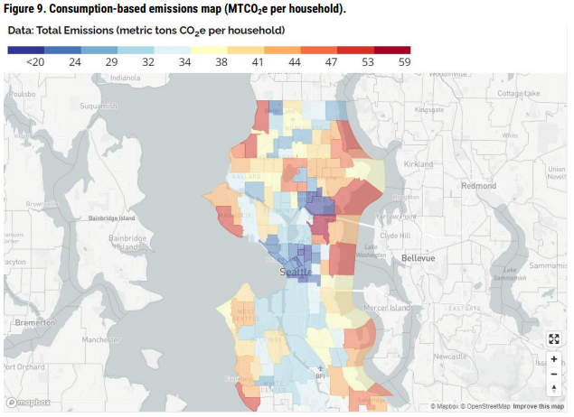
Geospatial technology is touching every aspect of urban planning for the Smart cities of the future. From tracking resources to delivering urban services and developing dynamic city management systems, many cities rely on GIS technology [4]. From Singapore’s Digital Twin of the ENTIRE CITY to Seattle’s use of GIS to help meet its greenhouse gas reduction targets, geospatial technology is helping to create more efficient, safe, and livable cities around the world.
In Seattle, the city uses the information collected on a wide range of issues to develop targeted policies and programs to reduce emissions, such as the Building Tune-Ups program that provides technical assistance to building owners and managers to optimize their energy use. Seattle also tracks its progress toward its sustainability goals using GIS technology to create interactive dashboards and maps that show the city’s progress on key sustainability indicators [5].
Unconventional applications of geospatial technology
Having now seen some of the most exciting applications in which geospatial technology is positively impacting the planet, we invite you to check out part two of this article in which we will discuss some of the more unconventional or ‘outside-the-box’ ways in which this technology is also making a significant difference.
Sources
[2] https://www.epa.gov/climate-indicators/climate-change-indicators-wildfires
[3] https://news.stanford.edu/2023/02/28/zombie-forests/
[5] https://storymaps.arcgis.com/stories/edef8a10050f4615b8a749acd82b6be0


Be the first to comment